
Land utilization change detection method for a high-resolution multi-source remote sensing image

A high-resolution, remote sensing image technology, applied in the field of remote sensing applications, can solve problems such as low recognition accuracy, inability to fully utilize information, and low degree of automation in interpretation, achieving a high degree of automation

Pending Publication Date: 2019-04-19
BEIJING AEROSPACE TITAN TECH CO LTD
View PDF4 Cites 11 Cited by
  • Summary
  • Abstract
  • Description
  • Claims
  • Application Information

AI Technical Summary

Problems solved by technology

[0007] The technical problem mainly solved by the present invention is that the information cannot be fully utilized in the detection of land use change in high-resolution multi-source remote sensing images, the degree of interpretation automation is low, and the recognition accuracy is low

Method used


Image

  • Land utilization change detection method for a high-resolution multi-source remote sensing image

Examples


Embodiment Construction

[0026] The embodiments of the present invention will be described in detail below in conjunction with the accompanying drawings, so that the advantages and features of the present invention can be more easily understood by those skilled in the art, so as to define the protection scope of the present invention more clearly.

[0027] Overall technical process

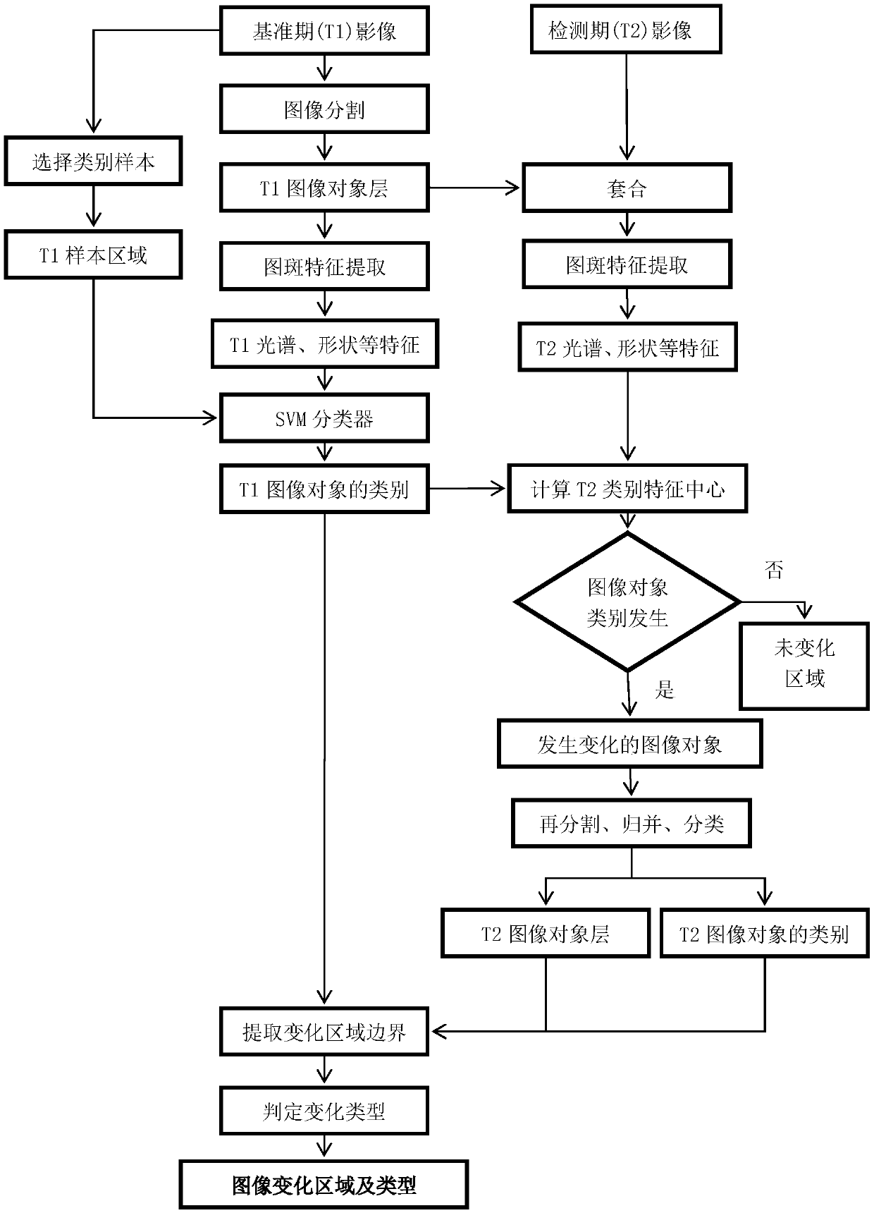
[0028] The overall technical process of the present invention is as attached figure 1 shown. It is mainly divided into three links, which are image segmentation and spot contour optimization, spot feature extraction, and change discovery independent of spectral calibration. Through these technical links, various problems in the analysis of high-resolution multi-source remote sensing data are solved, and the detection of land use change in high-resolution multi-source remote sensing images is realized.

[0029] 1. Image segmentation and spot contour optimization

[0030] The first is to use only the similarity of image ...


PUM


Abstract

The invention discloses a land utilization change detection method for a high-resolution multi-source remote sensing image. The method comprises the following steps: step 1) carrying out image segmentation on a reference period T1 image to obtain an object layer of the reference period T1 image, carrying out image spot feature extraction on the T1 image to obtain image features, and inputting theimage features into a trained classifier to obtain the category of each image object on the T1 image; step 2) acquiring a detection period T2 image, sleeving a T1 image object layer on the T2 image, performing image spot feature extraction to acquire image features, and calculating a feature center of each image object category of the T2 image according to the category of each image object on theT1 image; step 3) comparing the feature center of each image object category of the T2 image with the image features, if category change is found, performing re-segmentation and merging on the changedimage objects based on internal consistency to generate an image object layer, and judging category information of the image object layer; And 4) comparing the types of the T1 image and the T2 imageto generate a vector boundary and a change type of the change area.

Description

technical field [0001] The invention relates to the field of remote sensing applications, in particular to a method for detecting land use changes using high-resolution multi-source remote sensing images. Background technique [0002] The "Thirteenth Five-Year Plan for Scientific and Technological Innovation and Development of Land and Resources" requires the application of land surveys, land law enforcement, mineral development law enforcement, major geological disaster emergency investigation and monitoring, etc., and focuses on improving the quantitative, engineering, and intelligent data of air-space observation technology Processing and special product production capacity, development of software platform, improvement of service efficiency, improvement of satellite application’s ability to serve government decision-making, support for the construction of investigation and supervision system, and lay a solid foundation for the construction of ecological land and smart lan...

Claims


Application Information

Patent Timeline
Patent Type & Authority Applications(China)
IPC IPC(8): G06K9/00G06K9/62
CPCG06V20/13G06F18/2411
Inventor 李磊吴岳姜航
Owner BEIJING AEROSPACE TITAN TECH CO LTD
Learn More