Algorithm, system and device for eliminating unmanned aerial vehicle positioning NLOS, and storage medium

A technology for eliminating systems and drones, applied in the field of communications, can solve the problems of not receiving GPS signals and a large amount of calculation, and achieve the effects of simple calculation steps, accurate positioning results, and easy implementation.

Active Publication Date: 2019-05-14
XIDIAN UNIV
View PDF5 Cites 3 Cited by
  • Summary
  • Abstract
  • Description
  • Claims
  • Application Information

AI Technical Summary

Problems solved by technology

The positioning of UAVs used to always rely on global satellite navigation systems, but GPS has great flaws: large errors will occur in harsh environments, and GPS signals will not be received in some remote areas.
Although this method is improved compared to the first method, it also has a relatively large amount of calculation
At the same time, the above two algorithms require at least three base stations to complete the positioning.

Method used


Image

  • Algorithm, system and device for eliminating unmanned aerial vehicle positioning NLOS, and storage medium
  • Algorithm, system and device for eliminating unmanned aerial vehicle positioning NLOS, and storage medium
  • Algorithm, system and device for eliminating unmanned aerial vehicle positioning NLOS, and storage medium

Examples


Embodiment Construction

[0046] The present invention will be further described in detail below in conjunction with specific examples, but the embodiments of the present invention are not limited thereto.

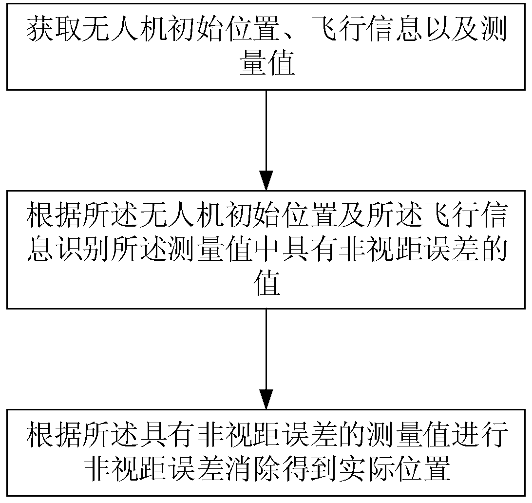
[0047] The embodiment of the present invention provides an NLOS elimination algorithm for UAV positioning. The steps are as follows:

[0048] Obtain the initial position, flight information and measurement values ​​of the drone;

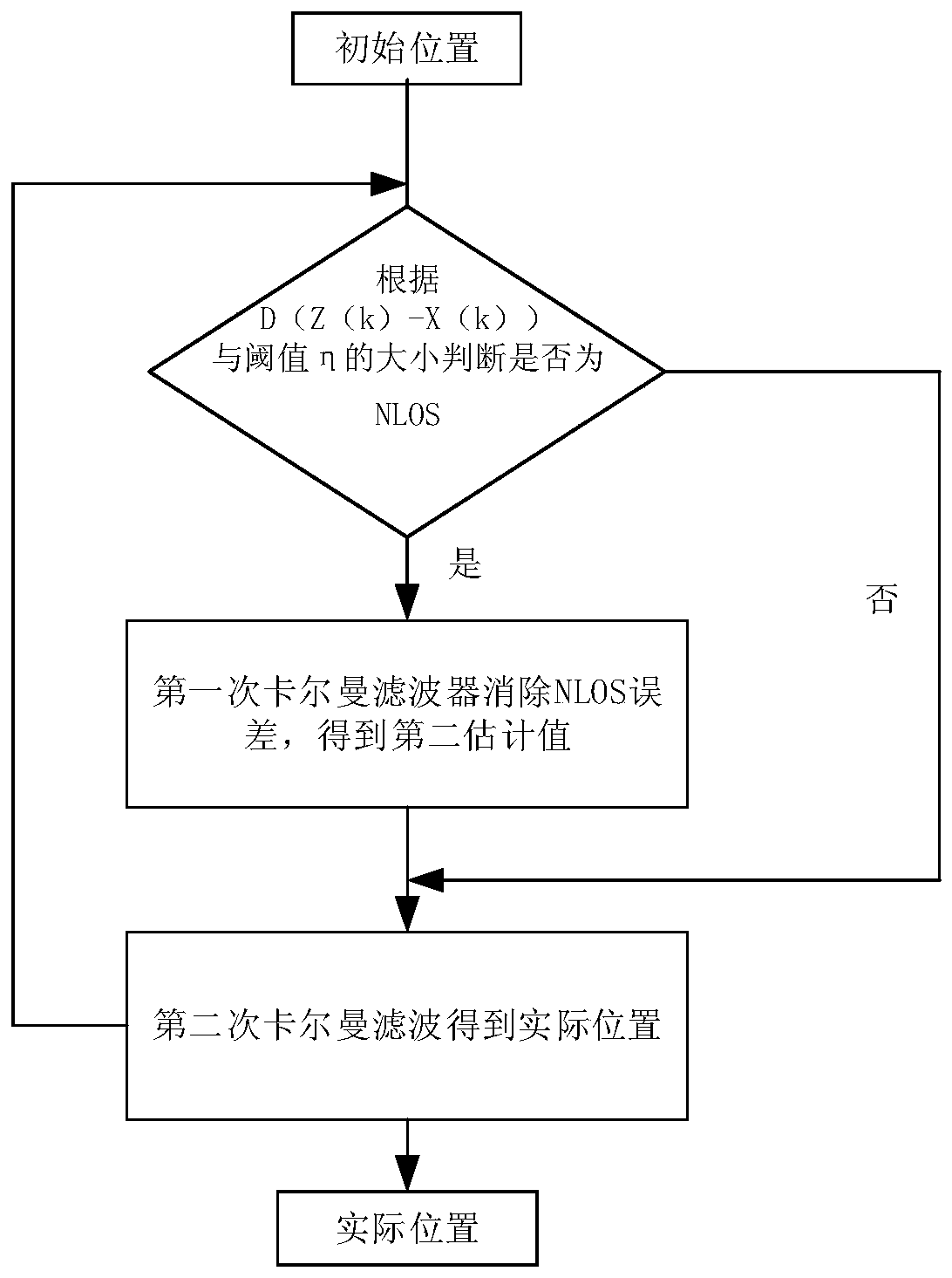
[0049] Identifying a value with a non-line-of-sight error in the measurement value according to the initial position of the drone and the flight information;

[0050] The actual position is obtained by eliminating the non-line-of-sight error according to the measurement value with the non-line-of-sight error.

[0051] Specifically, by first acquiring the measurement value with non-line-of-sight error, the measurement value with non-line-of-sight error can be eliminated, and the measurement value can be processed more accurately, so that the positioning result is more accurate, and ...


PUM


Abstract

The invention belongs to the technical field of communication, and particularly relates to an algorithm, system and device for eliminating unmanned aerial vehicle positioning NLOS, and a storage medium. The algorithm comprises the following steps: obtaining an initial position of an unmanned aerial vehicle, flight information and a measured value; identifying a value having a non-line of sight error in the measured value according to the initial position of the unmanned aerial vehicle and the flight information; and eliminating the non-line of sight error according to the measured value havingthe non-line of sight error to obtain an actual position. According to the algorithm provided by the embodiment of the invention, by obtaining the measured value having the non-line of sight error and eliminating the measured value having the non-line of sight error at first, the measured value can be processed more accurately, so that the positioning result is more accurate, and the method for eliminating the non-line of sight error used in the invention can greatly shorten the positioning time.

Description

Technical field [0001] The present invention belongs to the field of communication technology, and specifically relates to an NLOS elimination algorithm, system, device and storage medium for UAV positioning. Background technique [0002] In recent years, with the continuous development of drone-related technologies, drones have been used in more and more fields: disaster first aid, target tracking, agriculture and even war. The positioning of UAVs used to always rely on global satellite navigation systems, but GPS has a big defect: in harsh environments, there will be large errors, and in some remote areas, GPS signals may not be received. . Therefore, the wireless positioning of drones has attracted more and more attention, and has also been studied by more and more researchers. [0003] Due to the existence of tall buildings and obstacles, wireless signals propagate between the UAV and the reference station through refraction and reflection, thus forming a non-line-of-sight NL...

Claims


Application Information

Patent Timeline
Patent Type & Authority Applications(China)
IPC IPC(8): G01S5/06
Inventor 相征齐庆凯任鹏
Owner XIDIAN UNIV
Why Eureka
Try Eureka