Identification method for sandstone uranium deposit supply-discharge-runoff area in ETM remote sensing image

A remote sensing image and recognition method technology, applied in the field of multispectral remote sensing analysis, can solve problems such as difficult to distinguish, differences in optical information between runoff areas and recharge areas, etc.

Inactive Publication Date: 2019-05-24
BEIJING RES INST OF URANIUM GEOLOGY
View PDF4 Cites 5 Cited by
  • Summary
  • Abstract
  • Description
  • Claims
  • Application Information

AI Technical Summary

Problems solved by technology

[0004] At present, the traditional remote sensing method used for the identification of track-replenishment areas mostly uses medium-resolution satellite remote sensing data to extract the humidity index and vegetation index to identify the excretion area; however, due to the small difference in optical information between the runoff area and the recharge area, only the optical features of the image indistinguishable

Method used


Image

  • Identification method for sandstone uranium deposit supply-discharge-runoff area in ETM remote sensing image

Examples


Embodiment Construction

[0034] The present invention will be described in further detail below in conjunction with the accompanying drawings and embodiments.

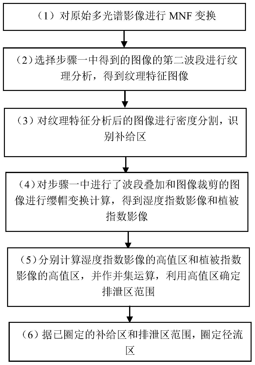
[0035] like figure 1 As shown, a kind of ETM remote sensing image sandstone uranium ore recharge-discharge-runoff area identification method provided by the present invention, the method specifically comprises the following steps:

[0036] Step (1) performs MNF transformation on the original multispectral image to obtain the image MNF[n]. This step includes the following steps:

[0037] Step (1.1) The original ETM 7-band data is recorded as ETM[n], and the ETM image is cut according to the working area to obtain the ETM image within the working area, which is recorded as the image ETM_cut[n].

[0038] Wherein, n is the number of bands, n=7.

[0039] Step (1.2) Perform MNF transformation processing on the image ETM_cut[n] to obtain the image MNF[n].

[0040] Wherein, n is the number of bands, n=7.

[0041] Step (2) Select the second band of...


PUM


Abstract

The invention belongs to the technical field of multi-spectral remote sensing analysis, and specifically discloses an ETM remote sensing image sandstone uranium recharge-excretion-runoff area identification method: MNF transformation is performed on the original multi-spectral image to obtain image MNF[n]; image MNF is selected [ The second band of n] performs texture analysis to obtain the texture feature image MNF2_Texture; the image MNF2_Texture is density-divided to identify the replenishment area B; the image ETM_cut[n] is calculated by the cap transformation to obtain the humidity indeximage and the vegetation index image, respectively recorded as ETM_Wetness and ETM_Greenness; respectively calculate the high value area of the moisture index image ETM_Wetness high value area and thevegetation index image ETM_Greenness, and perform the union operation, and use the high value area to determine the discharge area P range; according to the above-defined circled supply area B and The discharge area P ranges and the runoff area J is circled. The method solves the problem of image segmentation in runoff area and recharge area, and combines vegetation index analysis to realize quantitative identification of basin recharge area, runoff area and discharge area.

Description

technical field [0001] The invention belongs to the technical field of multispectral remote sensing analysis, and in particular relates to a method for identifying sandstone uranium ore recharge-discharge-runoff areas in ETM remote sensing images. Background technique [0002] The hydrogeological conditions for the formation of sandstone uranium deposits of epigenetic origin are extremely important. The sedimentary basins producing uranium should be large-scale artesian basins with abundant water supply areas and long-distance runoff areas with gentle rock formations (favorable for groundwater slow flow and fully oxidized sandstone), and has a distinct discharge zone. The interlayer oxidation zone formed in the sedimentary cover of the basin is the product of groundwater participating in the epigenetic transformation. Without the epigenetic transformation of groundwater, it is impossible to form the interlayer oxidation zone. Large infiltration of surface leaching water, p...

Claims


Application Information

Patent Timeline
Patent Type & Authority Applications(China)
IPC IPC(8): G06K9/00G01N21/25
Inventor 李瀚波潘蔚方茂龙余长发田青林
Owner BEIJING RES INST OF URANIUM GEOLOGY
Why Eureka
Try Eureka