Detection system and method of slope planting vegetation protection function based on image analysis
A technology of protection function and detection system, applied in the fields of instrument, calculation, character and pattern recognition, etc., can solve the problems of waste of manpower and material resources, low frequency of manual detection, differences, etc., to save costs, improve work efficiency and accuracy Effect
- Summary
- Abstract
- Description
- Claims
- Application Information
AI Technical Summary
Problems solved by technology
Method used
Image
Examples
Embodiment 1
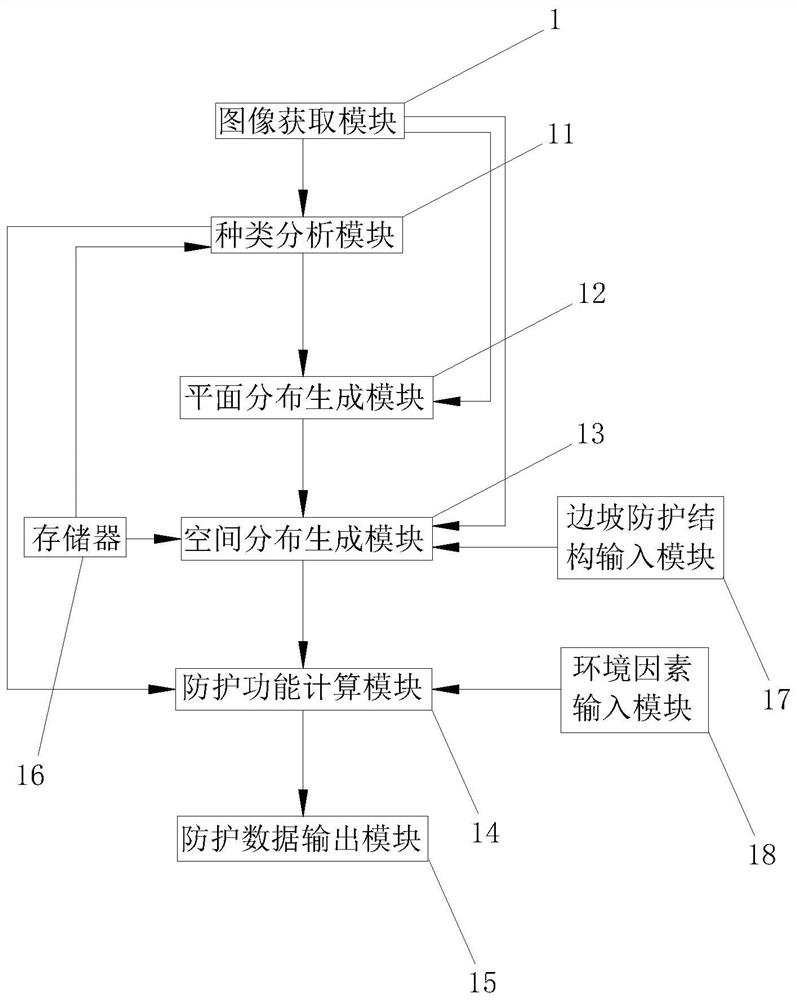
[0039] Embodiment 1: The detection system of slope planting vegetation protection function based on image analysis, such as figure 1 As shown, it includes an image acquisition module 1 , a category analysis module 11 , a plane distribution generation module 12 , a space distribution generation module 13 , a protection function calculation module 14 , a protection data output module 15 and a memory 16 .
[0040] The image acquisition module 1 is communicatively connected with the type analysis module 11 , the planar distribution generation module 12 and the spatial distribution generation module 13 . The image acquisition module 1 acquires hyperspectral image feature information and coordinate information of the region to be detected, and transmits the hyperspectral image feature information to the type analysis module 11 and the planar distribution generation module 12, and transmits the coordinate information to the spatial distribution generation module 13.
[0041] The type...
Embodiment 2
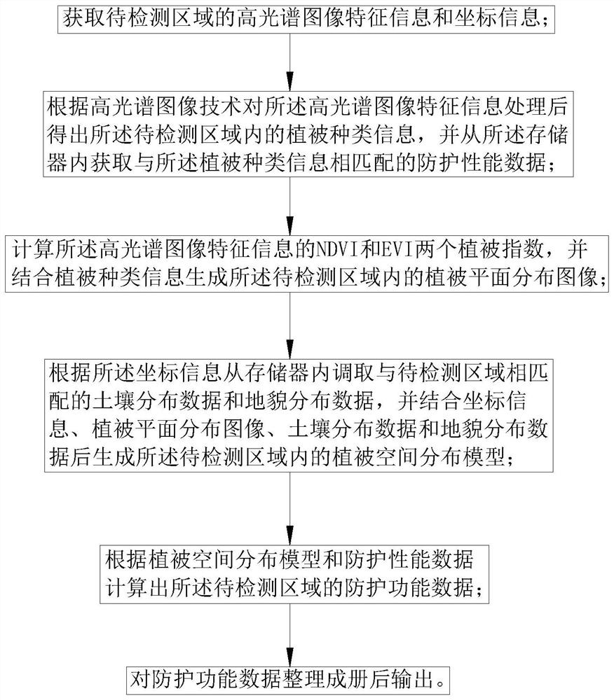
[0050] Embodiment 2: The detection method of slope planting vegetation protection function based on image analysis, such as figure 1 and image 3 shown, including the following steps:
[0051] Step 1, acquiring hyperspectral image feature information and coordinate information of the region to be detected.
[0052] Step 2: Process the feature information of the hyperspectral image according to the hyperspectral image technology to obtain vegetation type information in the area to be detected, and obtain protection performance data matching the vegetation type information from the memory 16 .
[0053] Step 3: Calculate the two vegetation indices NDVI and EVI of the hyperspectral image feature information, and combine the vegetation type information to generate a vegetation plane distribution image in the area to be detected.
[0054] Step 4: According to the coordinate information, the soil distribution data and landform distribution data matching the area to be detected are ...
PUM
 Abstract
Description
Claims
Application Information
 - R&D
- Intellectual Property
- Life Sciences
- Materials
- Tech Scout
- Unparalleled Data Quality
- Higher Quality Content
- 60% Fewer Hallucinations
Browse by: Latest US Patents, China's latest patents, Technical Efficacy Thesaurus, Application Domain, Technology Topic, Popular Technical Reports.
© 2025 PatSnap. All rights reserved.Legal|Privacy policy|Modern Slavery Act Transparency Statement|Sitemap|About US| Contact US: help@patsnap.com


