Beidou_SINS compact combined navigation system and method based on multi-core DSP

A navigation system and tightly combined technology, which is applied in the field of Beidou-SINS tightly combined navigation system, can solve the problems of reduced navigation accuracy, deterioration of low-cost SINS navigation accuracy, failure, etc., and achieves high refresh frequency and reduces the burden of data communication.

Pending Publication Date: 2019-06-14
INNER MONGOLIA UNIV OF TECH
View PDF2 Cites 5 Cited by
  • Summary
  • Abstract
  • Description
  • Claims
  • Application Information

AI Technical Summary

Problems solved by technology

SINS has the characteristics of high short-term navigation accuracy, but due to the influence of random errors of low-cost inertial devices, the navigation accuracy of low-cost SINS deteriorates sharply with time, making it unable to work alone for a long time
The satellite navigation system has the advantage that the navigation accuracy does not change with time, but when the satellite signal is blocked or subjected to electromagnetic interference, the navigation accuracy will decrease or even fail

Method used


Image

  • Beidou_SINS compact combined navigation system and method based on multi-core DSP
  • Beidou_SINS compact combined navigation system and method based on multi-core DSP
  • Beidou_SINS compact combined navigation system and method based on multi-core DSP

Examples


Embodiment Construction

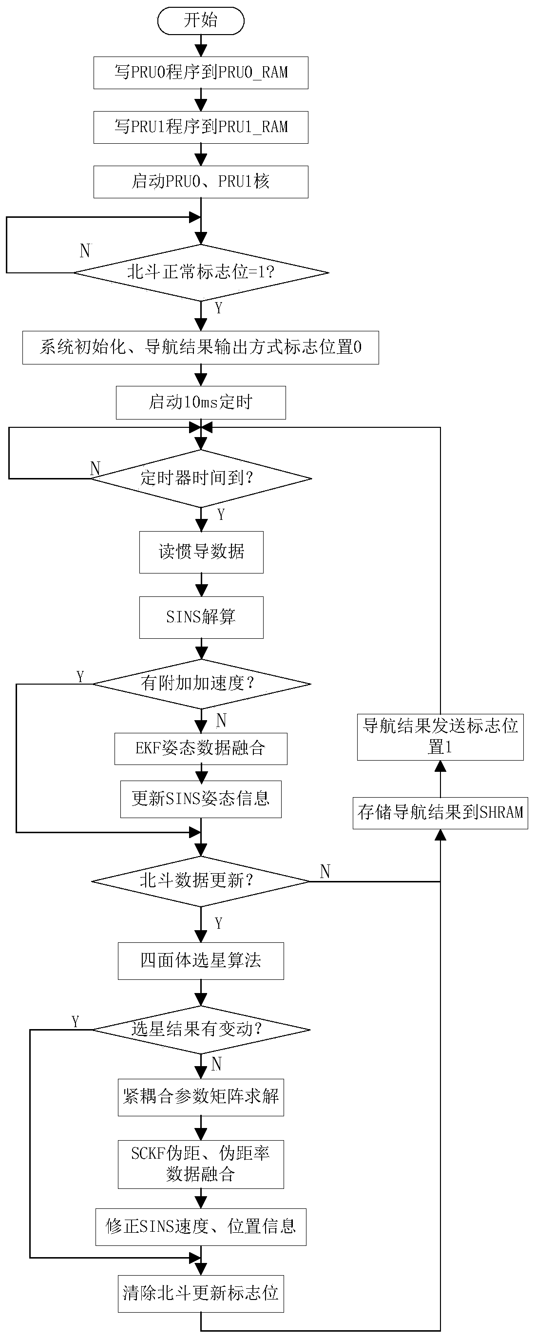
[0105] The technical solution of the present invention will be further described in detail below in conjunction with the accompanying drawings, but the protection scope of the present invention is not limited to the following description.

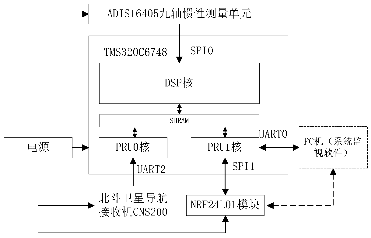
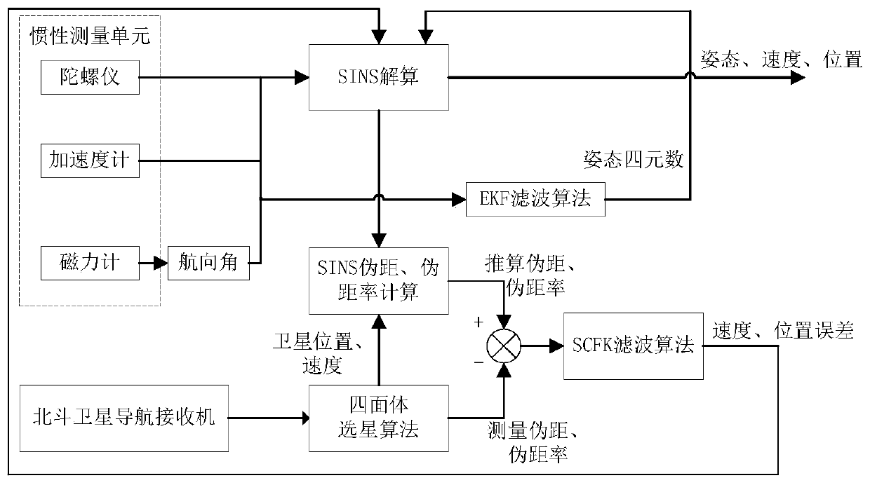
[0106] Such as figure 1 As shown, the Beidou_SINS tight integrated navigation system based on multi-core DSP includes a multi-core DSP unit, a micro-inertial measurement unit and a Beidou satellite navigation receiver; the output terminals of the micro-inertial measurement unit and the Beidou satellite navigation receiver are connected to the multi-core DSP unit ;

[0107] The micro inertial measurement unit is used to measure the rotational angular velocity, acceleration and magnetic field strength information of the environment of the carrier;

[0108] The Beidou satellite navigation receiver is used to measure the satellite's position, pseudo-range, pseudo-range rate information and initial velocity and position information of the carri...


PUM


Abstract

The invention discloses a Beidou_SINS compact combined navigation system and method based on a multi-core DSP. The system comprises a micro inertial measurement unit used for measuring the rotation angular velocity and accelerated velocity of a carrier and the magnetic field intensity information of an environment; a Beidou satellite navigation receiver used for measuring the position, pseudo-range and pseudo-range rate information of a satellite and the initial velocity and position information of the carrier; a multi-core DSP unit used for collecting the data of the micro inertial measurement unit and the data of the Beidou satellite navigation receiver, for analyzing the data, selecting the satellite, correcting the measured range error and performing SINS resolving, estimating the posture information of an SINS, fusing the pseudo-range and pseudo-range rate data of a Beidou system and the SINS, estimating and compensating an SINS position error and velocity error, and then outputting navigation data with high accuracy and high refresh rate. According to the Beidou_SINS compact combined navigation system and method based on the multi-core DSP provided by the invention, the datafrom multiple sensors can be fused, and the data processing can be performed on the multi-core DSP unit, so that the compact combined navigation with high precision, dynamics and relatively high anti-interference performance is achieved.

Description

technical field [0001] The invention relates to the field of navigation, in particular to a Beidou-SINS tight integrated navigation system and method based on multi-core DSP. Background technique [0002] An inertial navigation system (INS) is generally composed of inertial devices such as gyroscopes and accelerometers and a navigation computer. The INS calculates the navigation parameters at the current moment based on the position, velocity and attitude information of the carrier at the previous moment, combined with the information measured by the inertial sensor. INS is mainly divided into two types: platform type and strapdown type. The strapdown inertial navigation system (SINS) has gradually replaced the platform type INS in the field of medium and low precision applications due to its small size, low power consumption, and simple structure. SINS has the characteristics of high short-term navigation accuracy, but due to the influence of random errors of low-cost iner...

Claims


Application Information

Patent Timeline
Patent Type & Authority Applications(China)
IPC IPC(8): G01S19/47G01C21/16
Inventor 张丽杰王鑫刘瑞姜涛
Owner INNER MONGOLIA UNIV OF TECH
Why Eureka
Try Eureka