
Unmanned aerial vehicle ground station system based on LabVIEW

A technology of unmanned aerial vehicle and ground station, applied in the field of unmanned aerial vehicle, it can solve the problems of limited control range and transmission range, unintuitive display of unmanned aerial vehicle data, and users' inability to observe the running status of unmanned aerial vehicle and ground station well. , to achieve the effect of good simulation function and large control range

Inactive Publication Date: 2019-06-25
NANJING KAITIANYAN UAV TECH CO LTD
View PDF0 Cites 1 Cited by
  • Summary
  • Abstract
  • Description
  • Claims
  • Application Information

AI Technical Summary

Problems solved by technology

[0004] The existing ground station, on the one hand, the control range is limited by the transmission range, on the other hand, the UAV data display is not intuitive, and the user cannot observe the operating status of the UAV and the ground station well

Method used


Image

  • Unmanned aerial vehicle ground station system based on LabVIEW

Examples


Embodiment Construction

[0012] The present invention will be further described below in conjunction with the accompanying drawings.

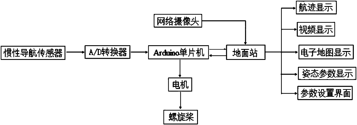
[0013] Such as figure 1 As shown, the present invention includes a drone and a ground station; the drone includes a main controller, an inertial navigation sensor, and a network camera; the inertial navigation sensor collects flight data of the drone and sends it to the main controller; The main controller is an Arduino single-chip microcomputer; the Arduino single-chip microcomputer is accompanied by a W5100 network expansion module; the ground station includes a LabVIEW virtual instrument development platform; the LabVIEW virtual instrument development platform accesses the W5100 network expansion module network through the TCP / IP protocol, thereby obtaining inertia The flight data of the unmanned aerial vehicle collected by the navigation sensor; the LabVIEW virtual instrument development platform accesses the network camera through the TCP / IP protocol, thereby obta...


PUM


Abstract

The invention provides an unmanned aerial vehicle ground station system based on LabVIEW. The system comprises an unmanned aerial vehicle and a ground station. The unmanned aerial vehicle comprises amain controller, an inertial navigation sensor and a network camera. The inertial navigation sensor collects the flight data of the unmanned aerial vehicle and sends the data to the main controller. The main controller is an Arduino singlechip. The Arduino singlechip is provided with a W5100 network expansion module. The ground station comprises a LabVIEW virtual instrument development platform. The LabVIEW virtual instrument development platform accesses the W5100 network expansion module network through a TCP / IP protocol to acquire the unmanned aerial vehicle flight data collected by the inertial navigation sensor. The LabVIEW virtual instrument development platform accesses the network camera through the TCP / IP protocol to acquire the video image data taken by the network camera. According to the invention, the system has the advantages of unlimited data transmission range and large control range, enables a user to observe the running state of the ground station well, and has a goodsimulation function.

Description

technical field [0001] The invention belongs to the technical field of unmanned aerial vehicles, and in particular relates to a ground station system for unmanned aerial vehicles based on LabVIEW. Background technique [0002] UAV technology has great application prospects in many fields such as surveillance and surveillance, data acquisition, and telemetry exploration. The UAV ground station is an important part of the UAV system, providing command and control of the UAV and ensuring data communication between the aircraft and the ground. [0003] The main functions of the UAV ground station include: collecting control information on the UAV, on-board mission loads and communication link equipment through the input device, combining the above control information into a standard control command and sending it to the UAV and link equipment ;Receive real-time telemetry data of drones, on-board mission loads and communication link equipment, analyze the above data and reflect ...

Claims


Application Information

Patent Timeline
Patent Type & Authority Applications(China)
IPC IPC(8): G05B19/042H04L29/06
Inventor 仇翰章陈明健
Owner NANJING KAITIANYAN UAV TECH CO LTD
Learn More