An urban impermeable surface extraction method based on a high-resolution satellite remote sensing image

A satellite remote sensing image, high-resolution technology, applied in image enhancement, image analysis, image data processing, etc., can solve problems such as limited use, lack of high-resolution remote sensing image data, and difficulty in extracting high-resolution images, and achieve inversion good effect

Inactive Publication Date: 2019-06-25
GUANGZHOU INST OF GEOGRAPHY GUANGDONG ACAD OF SCI
View PDF4 Cites 21 Cited by
  • Summary
  • Abstract
  • Description
  • Claims
  • Application Information

AI Technical Summary

Problems solved by technology

However, most of the existing high-resolution images only have visible and near-infrared bands, except for a few in the mid-infrared band, which limits the use of these methods.
At present, there are few algorithms developed for high-resolution images, which brings great difficulties to the extraction of impervious surfaces in high-resolution images
In addition, research on urban-scale fine impervious surfaces mainly focuses on how to quickly and accurately extract more detailed spa

Method used


Image

  • An urban impermeable surface extraction method based on a high-resolution satellite remote sensing image
  • An urban impermeable surface extraction method based on a high-resolution satellite remote sensing image
  • An urban impermeable surface extraction method based on a high-resolution satellite remote sensing image

Examples


Embodiment Construction

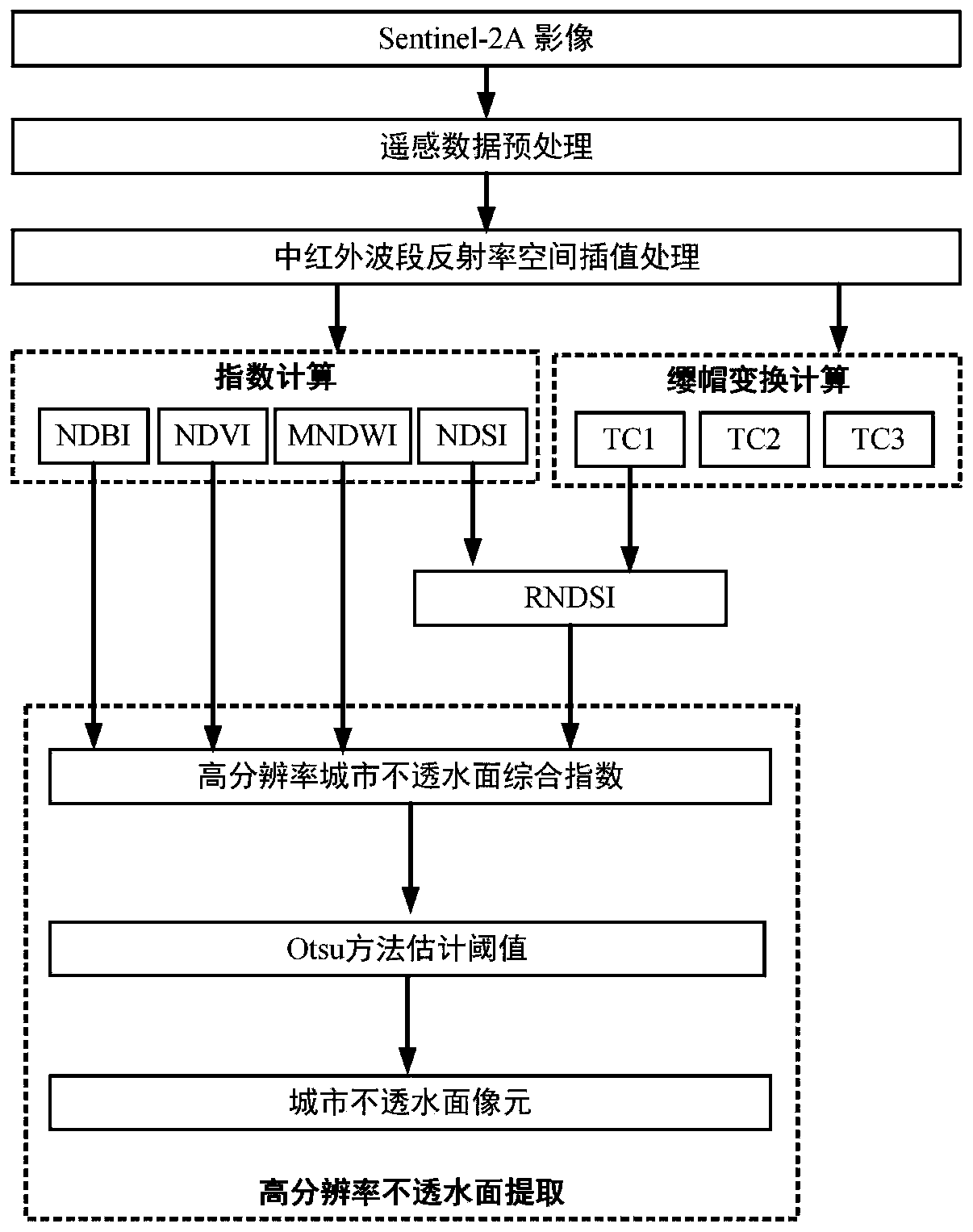
[0038] Such as figure 1 As shown, a method for extracting urban impervious surfaces based on high-resolution satellite remote sensing images includes the following specific steps:

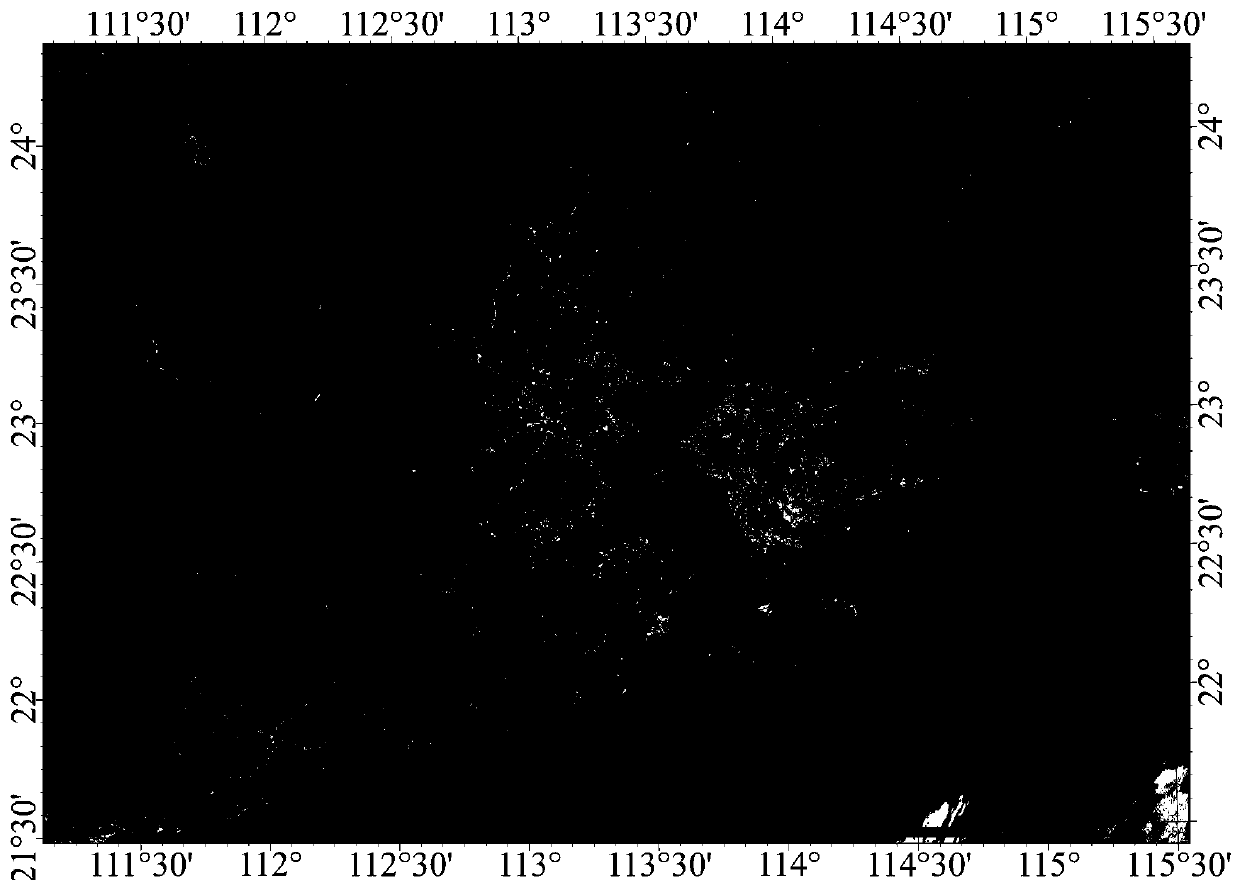
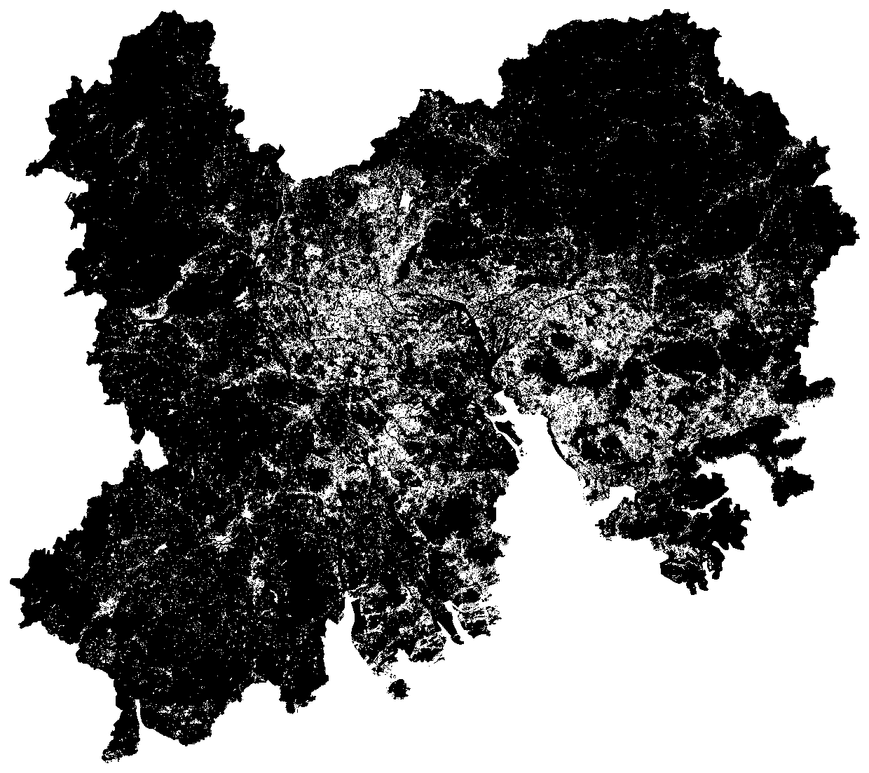
[0039] (1) if figure 2 As shown, in the embodiment of the present invention, the research area is located between 112°-115° east longitude and 21.5°-24° north latitude, belonging to the Guangdong-Hong Kong-Macao Greater Bay Area. The Guangdong-Hong Kong-Macao Greater Bay Area is an urban agglomeration composed of two special administrative regions of Hong Kong and Macao and nine cities of Guangzhou, Shenzhen, Zhuhai, Foshan, Zhongshan, Dongguan, Huizhou, Jiangmen, and Zhaoqing in Guangdong Province. It is a national construction of a world-class urban agglomeration and An important space carrier to participate in global competition. In the embodiment of the present invention, the Sentinel-2A remote sensing image is used as a data source to extract urban impervious surfaces with a spatial resolut...


PUM


Abstract

The invention discloses an urban impermeable surface extraction method based on a high-resolution satellite remote sensing image. A high-resolution satellite remote sensing image is used as a data source, and a new high-resolution urban impermeable surface comprehensive index is established by combining a normalized building index, a normalized vegetation index, an improved normalized water body index and a normalized soil index. According to the method, the difference between the impermeable surface and vegetation, water and naked bodies is considered, so that the problems of same spectrum offoreign matters and the like when the impermeable surface is extracted by a single index are avoided. Compared with a traditional method of independently using the impermeable surface index to extract the urban impermeable surface, the inversion effect of the model is good, the feature information of the impermeable surface can be mined, and a new technology and means are provided for accuratelyand comprehensively extracting the urban impermeable surface with the high spatial resolution within a large range.

Description

technical field [0001] The invention relates to the technical field of remote sensing image processing and information extraction, in particular to a method for extracting urban impervious surfaces based on high-resolution satellite remote sensing images. Background technique [0002] Urban impervious surface has become an indicator and an important driving force of urban environmental change and human-land interaction, and is a key basis for urban ecological environment planning and protection. In areas covered by impermeable surfaces, it is difficult for precipitation to return to the atmosphere through the interception and evaporation of tree canopies or enter the soil in the form of infiltration. The increase of impervious surface will increase the time, intensity and speed of urban runoff, affect the urban water cycle, and lead to an increase in the risk of flood and waterlogging disasters; in addition, the rapid expansion of surface impervious surface and the significa...

Claims


Application Information

Patent Timeline
IPC IPC(8): G06T3/40G06T5/00G06T7/11G06T7/136G06F17/18
Inventor 许剑辉张菲菲胡泓达赵怡钟凯文
Owner GUANGZHOU INST OF GEOGRAPHY GUANGDONG ACAD OF SCI
Why Eureka
Try Eureka