GNSS (global navigation satellite system) emergency monitoring equipment

A technology of global navigation satellites and monitoring equipment, applied in the field of field measurement, can solve the problems of many components, cannot meet the requirements of rapid deployment of emergency monitoring, and inconvenient to carry, etc., and achieve the effect of solving many components, fast installation and deployment, and easy portability

Pending Publication Date: 2019-06-28
SHANGHAI HUACE NAVIGATION TECH
View PDF0 Cites 1 Cited by
  • Summary
  • Abstract
  • Description
  • Claims
  • Application Information

AI Technical Summary

Problems solved by technology

[0004] The invention provides a GNSS emergency monitoring device, which is highly integrated, easy to carry, and can be quickly installed and deployed, which solves the problems of the traditional GNSS emergency monitoring equipment having many components, being inconvenient to carry and unable to meet the requirements of rapid deployment of emergency monitoring

Method used


Image

  • GNSS (global navigation satellite system) emergency monitoring equipment
  • GNSS (global navigation satellite system) emergency monitoring equipment
  • GNSS (global navigation satellite system) emergency monitoring equipment

Examples


Embodiment Construction

[0031] The present invention will be further described in detail below in conjunction with the accompanying drawings and embodiments. It should be understood that the specific embodiments described here are only used to explain the present invention, but not to limit the present invention. In addition, it should be noted that, for the convenience of description, only some structures related to the present invention are shown in the drawings but not all structures.

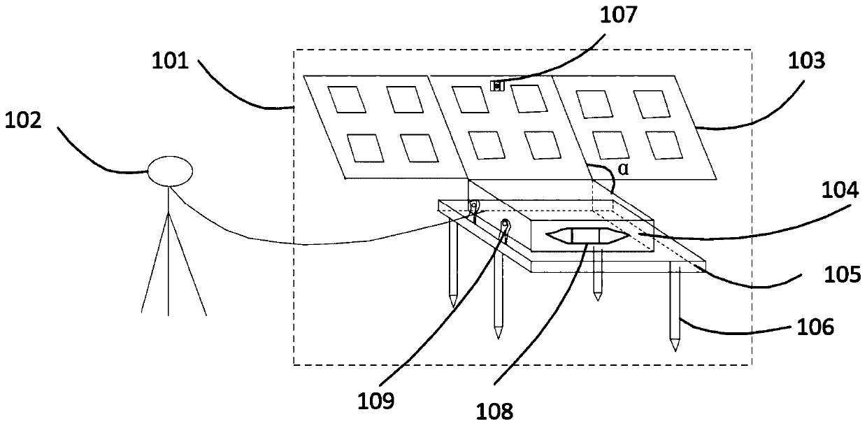
[0032] figure 1 The schematic diagram of the GNSS emergency monitoring equipment provided for the embodiment of the present invention, as figure 1 As shown, the device includes a GNSS receiver host 101 and a GNSS receiver antenna 102;

[0033] The GNSS receiver host 101 and the GNSS receiver antenna 102 are set separately, and are connected together through antenna connecting wires.

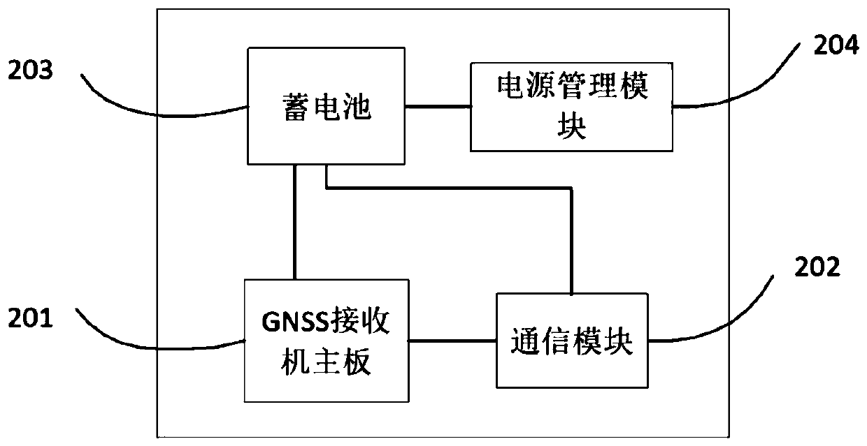
[0034] The GNSS receiver host 101 includes a first part 103 and a second part 104, and the first part 103 and the second part 104...


PUM


Abstract

The invention discloses GNSS (global navigation satellite system) emergency monitoring equipment. The equipment comprises a GNSS receiver main unit and a GNSS receiver antenna, wherein the GNSS receiver main unit comprises a first part and a second part, and the first part and the second part are rotationally connected; the first part comprises a solar battery structure; the second part comprisesa GNSS receiver mainboard, a communication module, a storage battery and a battery management module; the GNSS receiver mainboard is electrically connected with the GNSS receiver antenna, and used forperforming positioning analysis according to navigation satellite signals received by the GNSS receiver antenna. The GNSS emergency monitoring equipment is high in integration level, small in size, convenient to carry and capable of realizing rapid mounting deployment, and meets the demand of field emergency monitoring of geological disasters.

Description

technical field [0001] The embodiment of the present invention relates to the technical field of field measurement, in particular to a global navigation satellite system emergency monitoring equipment. Background technique [0002] Emergency monitoring of geological disasters is a very critical part of emergency response. Traditional global navigation satellite system (Global Navigation Satellite System, GNSS) emergency monitoring equipment can effectively monitor surface displacement, so as to determine whether geological disasters occur and the degree of damage of geological disasters. [0003] However, traditional GNSS emergency monitoring equipment has a lot of related components, which is very troublesome from delivery preparation to transportation, and it is easy to miss, and the equipment is also large in size. It is not easy to carry after arriving at the scene, and it is difficult to transport to the designated monitoring point. GNSS monitoring poses difficulties. ...

Claims


Application Information

Patent Timeline
Patent Type & Authority Applications(China)
IPC IPC(8): G01S19/17G01S19/34
Inventor 陶阳李宏祥徐恩强陈林张沛尧杨荣仕赵康德程华松
Owner SHANGHAI HUACE NAVIGATION TECH
Why Eureka
Try Eureka