Forestry resource collection method based on high-definition satellite remote sensing

A technology of satellite remote sensing and forestry resources, which is applied in the field of forestry resource collection, can solve the problems of not being able to use images completely clearly, it is difficult to distinguish between the same object and different spectrum, and "same spectrum and foreign object"

Inactive Publication Date: 2019-07-05
彭广惠
View PDF1 Cites 7 Cited by
  • Summary
  • Abstract
  • Description
  • Claims
  • Application Information

AI Technical Summary

Problems solved by technology

Blaschke and Strobl believe that the traditional pixel-based analysis method cannot fully clearly use the inherent spatial information of the image, and it is difficult to distinguish the phenomenon of "same object with different spectrum" and "same spectrum with different object" in the image. Neighboring or nearby cells are grouped into one category

Method used


Image

  • Forestry resource collection method based on high-definition satellite remote sensing
  • Forestry resource collection method based on high-definition satellite remote sensing

Examples


Embodiment Construction

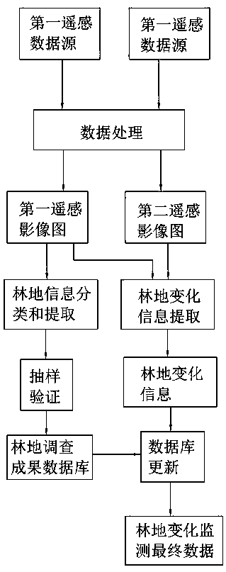
[0043] The present invention is further described in conjunction with the following examples.

[0044] This embodiment involves a method for collecting forestry resources based on high-definition satellite remote sensing. Therefore, it is necessary to obtain suitable remote sensing images. Generally, there are always some quality problems in remote sensing images that require necessary processing, such as removing noise, fog, clouds, etc. in the images. shadows etc. In order to facilitate visual interpretation or human-computer interaction interpretation, it is necessary to do some necessary image enhancement processing, which can highlight the forest information in the image, the image will become clearer, and the interpretability will be improved. Enhancement processing can be divided into spectral feature enhancement (prominent gray information), spatial feature enhancement (prominent line, edge, texture structure feature) and temporal information enhancement (for multi-tem...


PUM


Abstract

The invention discloses a forestry resource collection method based on high-definition satellite remote sensing. The method comprises the following steps of: selecting a first remote sensing data source and a second remote sensing data source, performing data processing to obtain a first remote sensing image and a second remote sensing image; forest land information extraction and change information extraction are carried out on the first remote sensing image; sampling verification, a forest land investigation result database is formed; performing change information extraction on the first remote sensing image and the second remote sensing image respectively; the change information extracted from the two forms forest land change information; the database updating module is used for updating the database to form forest land change monitoring final data. In the method for classifying and extracting forest land information, R, G and B are set to represent the average values of the red channel, the green channel and the blue channel of the image respectively, R, G and B are used as base numbers, a one-to-one corresponding formula is set according to different pieces of forest land information to classify the forest land information for extraction, and forest land information classification can be rapidly and accurately completed for extraction.

Description

technical field [0001] The invention relates to the technical field of forestry resource collection methods, in particular to a forestry resource collection method based on high-definition satellite remote sensing. Background technique [0002] Remote Sensing refers to remote sensing, which refers to recording the electromagnetic wave characteristics of the target from a distance without directly contacting the target object with a detection instrument, and revealing the characteristic properties of the object and the synthesis of changes through analysis. sex detection technology. Photography is the most common form of remote sensing. The camera does not touch the subject, but is separated by a certain distance. The image of the subject is recorded on the film through the lens. After chemical treatment, the photo will reproduce the subject. Image. The means used from photographing the target to reproducing the target is a kind of remote sensing technology. Combining remo...

Claims


Application Information

Patent Timeline
Patent Type & Authority Applications(China)
IPC IPC(8): G06K9/62G06T11/00G06F16/51
CPCG06T11/001G06F18/24
Inventor 彭广惠
Owner 彭广惠
Why Eureka
Try Eureka