Plain area three-dimensional geological model construction method based on multi-source heterogeneous data

A multi-source heterogeneous data and 3D geological technology, which is applied in the field of 3D geological model construction in plain areas based on multi-source heterogeneous data, can solve the problems of single types of modeling data, complex modeling software processes, and complicated modeling standardization work, etc. question

Active Publication Date: 2019-07-05
李潇
View PDF12 Cites 6 Cited by
  • Summary
  • Abstract
  • Description
  • Claims
  • Application Information

AI Technical Summary

Problems solved by technology

[0006] The main purpose of the present invention is to provide a three-dimensional geological model suitable for geological engineering layers, Cenozoic and bedrock in order to solve the problems of single modeling data types, complex modeling standard

Method used


Image

  • Plain area three-dimensional geological model construction method based on multi-source heterogeneous data
  • Plain area three-dimensional geological model construction method based on multi-source heterogeneous data
  • Plain area three-dimensional geological model construction method based on multi-source heterogeneous data

Examples


Embodiment Construction

[0035] The content of the present invention will be described in further detail below in conjunction with the accompanying drawings.
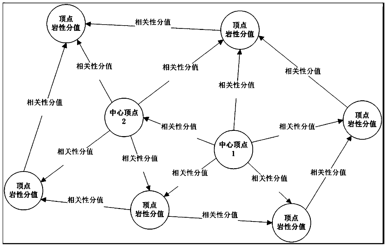
[0036] The main idea of ​​the present invention is to make different types of candidate data have different vector characteristics through vectorization and spatialization processing of geological survey data from multiple sources, and to use the original multi-source heterogeneous data for these processed The vector iterative modeling method establishes three-dimensional geological models of different depths, different scales, and different types. The present invention can realize the construction of most three-dimensional geological models in plain areas without complex generalization and standardization processing of borehole data, and has strong accurate modeling ability.

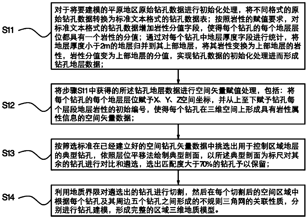
[0037] The present invention provides a method for building a three-dimensional geological model in plain areas based on multi-source heterogeneous data. In step S11, th...


PUM


Abstract

The invention relates to a plain area three-dimensional geologic model construction method based on multi-source heterogeneous data, which comprises the following steps of 1, initializing plain area drilling data to be modeled to form a standard drilling data table; 2, performing space vectorization processing on the arranged drilling data; 3, drawing a typical section by optimally selecting a typical drill hole and using a horizon translation method, comparing and selecting other drill holes through the typical section, and selecting and reserving the drill hole with the higher matching degree; and 4, based on geological boundaries of different geological lithology and geological times, cutting the drill hole into different large areas from the vertical direction, and carrying out modeling processing on the drill hole sequence and the adjacent relation of each large area in the vertical direction. The method is suitable for the fine modeling of plain areas with complex strata interlacing, the requirement for source data is wide, the modeling can be supported for drilling data of different sources and different formats, and the method is suitable for rapid construction of differentgeological models with shallow, medium and deep depths.

Description

technical field [0001] The invention relates to the technical field of geological model construction, in particular to a three-dimensional geological model construction method in plain areas based on multi-source heterogeneous data. Background technique [0002] Cities are built on geological bodies, which means that the construction and development of cities cannot be separated from the foundation support of geological work. The urban 3D geological structure model is a typical application of 3D information technology in the field of urban geology. The main goal of its construction is to improve the visual expression of urban geological achievements and the computing power of spatial data fields, so as to contribute to the prediction and evaluation of geological resources and environment, urban planning and construction. , Key project construction provides basic data support. Urban geological work has been integrated with many urban development needs such as urban construct...

Claims


Application Information

Patent Timeline
IPC IPC(8): G06T17/20G06T17/05
CPCG06T17/05G06T17/20
Inventor 李潇韩征张磊
Owner 李潇
Why Eureka
Try Eureka