Tilt measurement method of surveying and mapping integrated machine based on GNSS receiver and IMU sensor

A tilt measurement and sensor technology, applied in the field of surveying and mapping, can solve problems such as low operation efficiency and large tilt measurement error

Active Publication Date: 2019-07-16
菲曼(北京)科技有限公司 +1
View PDF10 Cites 10 Cited by
  • Summary
  • Abstract
  • Description
  • Claims
  • Application Information

AI Technical Summary

Problems solved by technology

[0005] In order to solve the problems of low operating efficiency and large tilt measurement error caused by the existing surveying and mapping integrated machine due to the magnetic an

Method used


Image

  • Tilt measurement method of surveying and mapping integrated machine based on GNSS receiver and IMU sensor
  • Tilt measurement method of surveying and mapping integrated machine based on GNSS receiver and IMU sensor
  • Tilt measurement method of surveying and mapping integrated machine based on GNSS receiver and IMU sensor

Examples


Embodiment 1

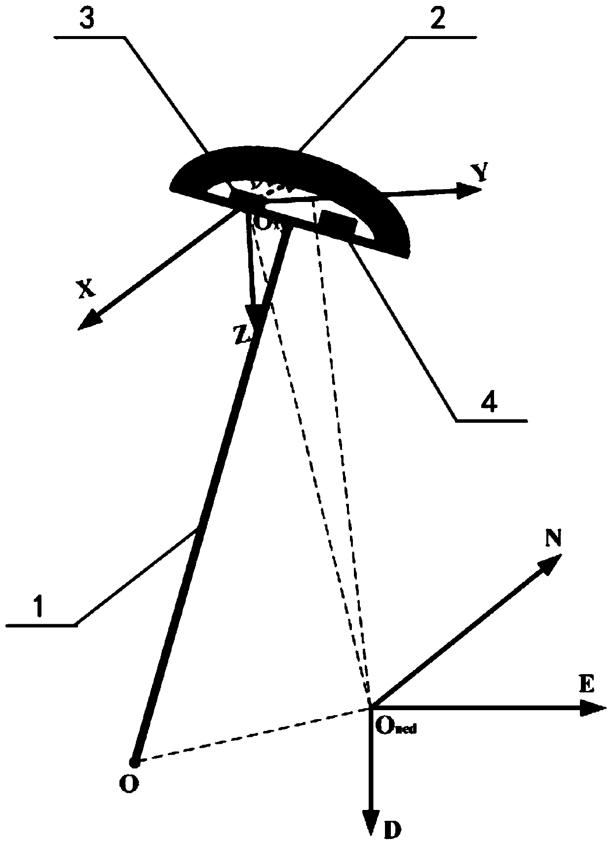
[0087] like Figure 1~2 As shown, the integrated surveying and mapping machine provided in this embodiment includes a centering pole 1, a GNSS receiver 2, an IMU sensor 3 and a microprocessor 4, wherein the GNSS receiver 2 is arranged on the centering pole 1 At the top, the IMU sensor 3 is arranged on the centering rod 1 and includes a 3-axis accelerometer and a 3-axis gyroscope, and the microprocessor 4 is also arranged on the centering rod 1 and communicates with all The GNSS receiver 2 and the IMU sensor 3. like figure 1As shown, the centering pole 1, the GNSS receiver 2, the IMU sensor 3 and the microprocessor 4 are all common accessories of the existing surveying and mapping integrated machine, and the surveying and mapping integrated machine of this embodiment is compatible with the existing The difference of the all-in-one surveying and mapping machine is that the IMU sensor 3 can be arranged at any position of the centering rod 1 like the microprocessor 4 due to the ...

Embodiment 2

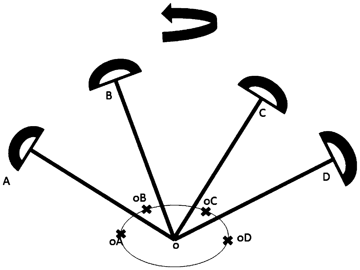
[0153] Such as image 3 As shown, this embodiment provides a further optimization solution based on Embodiment 1, that is, the tilt measurement method of the surveying and mapping integrated machine, which also includes the installation angle self-calibration method described in the following steps S201-S204 after the step S102 :

[0154] S201. Through the steps S103-S108, sequentially obtain the position coordinates of S centering rod bottoms obtained for different antenna phase center positions during the process of shaking the centering rod 1: ((φ O ) k1 (λ O ) k1 (h O ) k1 ) T , ((φ O ) k2 (λ O ) k2 (h O ) k2 ) T ,...,((φ O ) kS (λ O ) kS (h O ) kS ) T , wherein, S is a natural number not less than 2, and the position coordinate of the bottom end of the S-th centering rod is the newly acquired coordinate of the bottom end of the centering rod.

[0155] In the step S201, it is considered that the surveying and mapping integrated machine requires t...


PUM


Abstract

The invention relates to the technical field of surveying and mapping, and discloses a tilt measurement method of a surveying and mapping integrated machine based on a GNSS receiver and an IMU sensor.Through the creation of the tilt measurement method, repeated mutual circulation between prediction and correction of designed multi-dimensional unknown state variables is carried out by utilizing akalman filter algorithm principle, so that the multi-dimensional unknown state variables continually approach true values, and then newest three-dimensional attitude angles and newest rotation matrixes from an XYZ coordinate system to a NED coordinate system can be efficiently and accurately obtained based on the multi-dimensional unknown state variables; and finally, coordinates of an antenna phase center of the GNSS receiver are mapped to coordinates at the tail end position of a centering rod through geometric transformation, and thus tilt measurement is completed. According to the tilt measurement method of the surveying and mapping integrated machine based on the GNSS receiver and the IMU sensor, a measurement worker can be completely liberated from a task of bubble centering leveling, and work efficiency is improved; and in addition, any factory calibration does not need to be carried out, self-calibration can always be carried out in the operation process, the work efficiency and the accuracy rate are greatly improved, and unnecessary production processes are reduced.

Description

technical field [0001] The invention belongs to the technical field of surveying and mapping, and in particular relates to an inclination measurement method of a surveying and mapping integrated machine based on a GNSS receiver and an IMU sensor. Background technique [0002] The traditional surveying and mapping all-in-one machine requires surveyors to use the air bubbles of the centering pole to keep the all-in-one machine level. The latitude and longitude of the antenna phase center of the all-in-one machine is the latitude and longitude of the measuring point at the bottom of the centering pole, and the height of the measuring point is the antenna phase center of the all-in-one machine. Just subtract the known distance from the bottom of the pole to the phase center of the all-in-one antenna from the height. However, in order to ensure the accuracy, this method requires surveyors and mappers to maintain alignment for about half a minute, which is difficult and affects su...

Claims


Application Information

Patent Timeline
IPC IPC(8): G01C23/00G01S19/14
CPCG01C23/00G01S19/14G01S19/43G01S19/47G01C15/06G01S19/03
Inventor 刘俊杰李强
Owner 菲曼(北京)科技有限公司
Why Eureka
Try Eureka