A UAV monitoring method and system for embankment and dam failure scenarios

A technology of unmanned aerial vehicles and scenes, which is used in surveying devices, surveying and navigation, photogrammetry/video surveying, etc. problems, to achieve the effect of improving accuracy, quickly and accurately obtaining disaster information, and improving clarity

Active Publication Date: 2020-05-22
CHINA INST OF WATER RESOURCES & HYDROPOWER RES
View PDF4 Cites 0 Cited by
  • Summary
  • Abstract
  • Description
  • Claims
  • Application Information

AI Technical Summary

Problems solved by technology

[0008] Although remote sensing measurement technology has been widely used in river channel evolution and flood disasters, for short-duration flood disasters such as embankment and dam breaks, satellite remote sensing image data not only has a long data acquisition period, but also has a difficult time phase, which cannot meet timely emergency monitoring. needs

Method used


Image

  • A UAV monitoring method and system for embankment and dam failure scenarios
  • A UAV monitoring method and system for embankment and dam failure scenarios
  • A UAV monitoring method and system for embankment and dam failure scenarios

Examples


Embodiment Construction

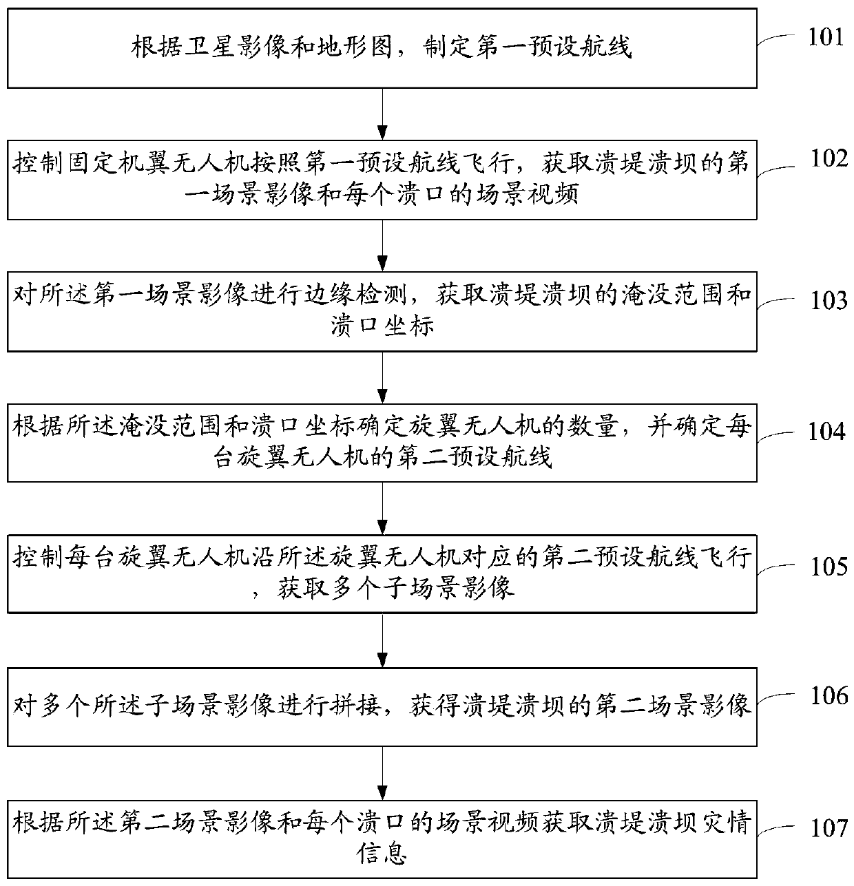
[0057] The purpose of the present invention is to provide a UAV monitoring method and system for embankment and dam failure scenes, so as to quickly and accurately obtain disaster information to meet the needs of timely emergency monitoring.

[0058] In order to make the above objects, features and advantages of the present invention more comprehensible, the invention will be further described in detail below in conjunction with the accompanying drawings and specific embodiments.

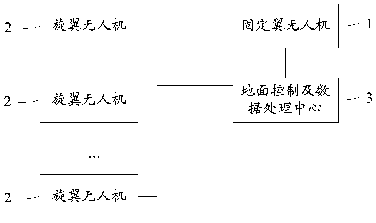
[0059] Such as figure 1 As shown, the present invention provides a kind of unmanned aerial vehicle monitoring method of scene of embankment and dam failure, and described monitoring method comprises the following steps:

[0060] Step 101, formulate the first preset route according to the satellite image and topographic map; specifically include: determine the initial submerged range according to the satellite image; determine the starting point coordinates and the end point coordinates according to ...


PUM


Abstract

The invention discloses an unmanned aerial vehicle monitoring method and an unmanned aerial vehicle monitoring system for a dam burst scene. The unmanned aerial vehicle monitoring method comprises steps that an unmanned aerial vehicle with fixed wings flies according to a first preset airline, and a first scene image of dam burst is acquired; edge detection on the first scene image is carried outto acquire the submerging range and the breach coordinate of the breached dam; the number of the rotor unmanned aerial vehicles is determined according to the submerging range and the breach coordinate, and each rotor unmanned aerial vehicle is controlled to fly along a second preset airline corresponding to the rotor unmanned aerial vehicle, and a plurality of sub-scene images and scene videos ofeach breach are acquired; Finally, the plurality of sub-scene images are spliced to acquire the second scene image of the dam burst; the disaster information of the dam burst is acquired according tothe second scene image and the scene video of each breach. According to the invention, the disaster information can be rapidly and accurately acquired by the unmanned aerial vehicle remote sensing technology, and the requirements of timely emergency monitoring are satisfied.

Description

technical field [0001] The invention relates to the field of flood monitoring, in particular to an unmanned aerial vehicle monitoring method and system for embankment and dam failure scenes. Background technique [0002] Every time a dam collapse accident occurs, there are hundreds or even thousands of casualties, causing great losses to the local economy. If it is washed away, a large amount of sediment carried by it will also cause soil desertification and soil salinization, which will be a devastating damage to the local natural environment and ecological environment. [0003] In order to reduce the harm caused by the break of dikes and dams, we can start from two aspects. On the one hand, it is to predict and prevent dike and dam breaks; on the other hand, it is to carry out rapid emergency treatment and disaster relief after the occurrence of dike and dam breaks. [0004] Due to the suddenness of dam breaks, it is difficult to predict when and where dam breaks will oc...

Claims


Application Information

Patent Timeline
Patent Type & Authority Patents(China)
IPC IPC(8): G01C11/00
CPCG01C11/00
Inventor 雷添杰庞治国王嘉宝张亚珍程子懿王维平李杨袁满程慧黄锦涛李翔宇李曙光杨会臣冯炜张炬李世灿杨轶龙秦景冯杰宫阿都路京选李爱丽周沅璟汪洋刘中伟万金红徐静
Owner CHINA INST OF WATER RESOURCES & HYDROPOWER RES
Why Eureka
Try Eureka