House surveying and mapping method and device, terminal and computer readable storage medium

A house and room technology, applied in the field of house surveying and mapping, can solve the problem that the floor plan of the house cannot be generated conveniently and quickly, and achieve the effect of avoiding drawing

Pending Publication Date: 2019-07-26
PINGAN CITY CONSTR TECH SHENZHEN CO LTD
View PDF4 Cites 17 Cited by
  • Summary
  • Abstract
  • Description
  • Claims
  • Application Information

AI Technical Summary

Problems solved by technology

[0004] The main purpose of the present invention is to provide a house surveying and mapping method, device, terminal and computer-readable storage medium

Method used


Image

  • House surveying and mapping method and device, terminal and computer readable storage medium
  • House surveying and mapping method and device, terminal and computer readable storage medium
  • House surveying and mapping method and device, terminal and computer readable storage medium

Examples


Example

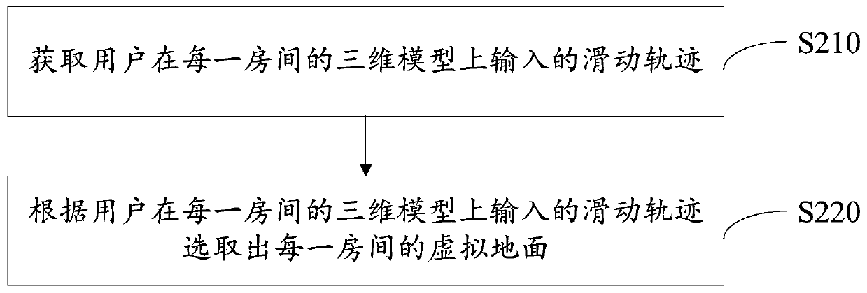
[0062] Further, please refer to image 3 , image 3 This is a detailed schematic diagram of the process of selecting the virtual floor of each room according to the three-dimensional model of each room in the embodiment of the present invention. Based on the first embodiment, step S200 includes:

[0063] Step S210: Obtain the sliding track input by the user on the three-dimensional model of each room;

[0064] In step S220, the virtual ground of each room is selected according to the sliding track input by the user on the three-dimensional model of each room.

[0065] The terminal can obtain the sliding operation input by the user on the three-dimensional model of each room in real time, and then select the virtual ground of each room according to the sliding operation on the three-dimensional model of each room. Specifically, when the user needs to move the 3D model, the user needs to slide on the 3D model to move the 3D model. When the user needs to select the virtual ground on the...


PUM


Abstract

The invention discloses a house surveying and mapping method. The method comprises the steps of obtaining three-dimensional image data of each room in a house; establishing a three-dimensional model of each room according to the three-dimensional image data; selecting a virtual ground of each room according to the three-dimensional model; drawing a plane graph of each room in the same coordinate direction according to the virtual ground of each room; and splicing the plane graphs of the rooms to form a house type graph of the house. The invention further discloses a house surveying and mappingdevice, a terminal and a computer readable storage medium. According to the technical scheme provided by the invention, the house is processed based on image recognition; the plane graph of each roomin the same coordinate direction is drawn; due to the consistency of planar graph directions, the planar graphs of all the rooms are spliced to form the house type graph of the house, the house typegraph of the house can be generated according to the measurement result of the virtual enhancement technology, later manual drawing is avoided, and great convenience is brought to house measurement and house type graph drawing.

Description

technical field [0001] The present invention relates to the technical field of house surveying and mapping, in particular to a house surveying and mapping method, device, terminal and computer-readable storage medium. Background technique [0002] At present, the existing virtual augmented reality technology (Augmented Reality) on the market is mostly based on measuring the vertical and horizontal distances of houses. This technology can generate a rough style map of a room, but it cannot generate a complete floor plan of the house; while traditional The measurement method of the house needs to be measured with the help of an instrument, and manual drawing is required in the later stage, and the drawing process is more complicated. [0003] Therefore, how to generate the floor plan of the house conveniently and quickly is a kind of problem to be solved urgently. Contents of the invention [0004] The main purpose of the present invention is to provide a house surveying an...

Claims


Application Information

Patent Timeline
IPC IPC(8): G06F17/50G06T17/00G06T19/20
CPCG06T17/00G06T19/20G06F30/13
Inventor 肖文轩郑锋吴婷婷
Owner PINGAN CITY CONSTR TECH SHENZHEN CO LTD
Why Eureka
Try Eureka