Positioning and navigation method, positioning and navigation device and storage medium

A technology of positioning and navigation and position information, applied in the field of positioning and navigation, can solve the problems of GPS satellite signal occlusion and interference, inaccurate and complicated positioning and navigation, and achieve the effect of accurate positioning and navigation and solving poor positioning and navigation.

Inactive Publication Date: 2019-08-13
GUILIN UNIV OF ELECTRONIC TECH
View PDF6 Cites 4 Cited by
  • Summary
  • Abstract
  • Description
  • Claims
  • Application Information

AI Technical Summary

Problems solved by technology

[0002] At present, the demand for indoor positioning and navigation is increasing, and the requirements for it are also getting higher and higher. Currently, the most widely used is to use the global positioning system (global positioning system, GPS) for navigation. However, due to the complex indoor environment, GPS Satellite signals are blocked and interfered, which can easily lead to inaccurate positioning and navigation

Method used


Image

  • Positioning and navigation method, positioning and navigation device and storage medium
  • Positioning and navigation method, positioning and navigation device and storage medium
  • Positioning and navigation method, positioning and navigation device and storage medium

Examples


Embodiment Construction

[0021] The principles and features of the present invention are described below in conjunction with the accompanying drawings, and the examples given are only used to explain the present invention, and are not intended to limit the scope of the present invention.

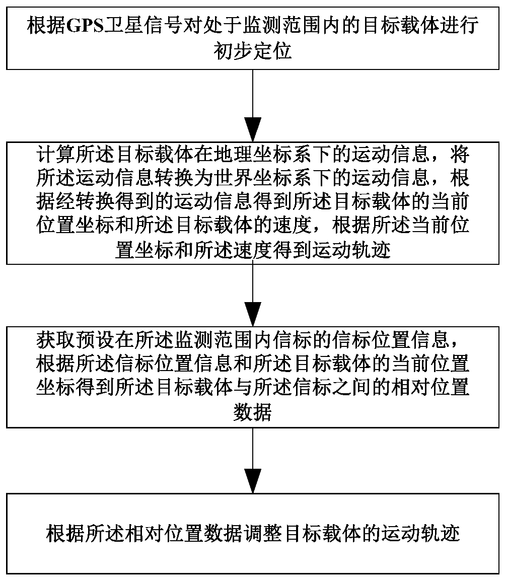
[0022] figure 1 It is a schematic flowchart of a positioning and navigation method provided by an embodiment of the present invention.

[0023] like figure 1 As shown, a positioning navigation method includes the following steps:

[0024] Preliminary positioning of the target carrier within the monitoring range is carried out according to the GPS satellite signal.

[0025] calculating the motion information of the target carrier in the geographic coordinate system, converting the motion information into motion information in the world coordinate system, and obtaining the current position coordinates of the target carrier and the target carrier according to the converted motion information The velocity of the targ...


PUM


Abstract

The invention provides a positioning and navigation method, a positioning and navigation device and a storage medium, wherein the method comprises the following steps: performing primary positioning for a target carrier in a monitoring range, calculating motion information of the target carrier under a geographic coordinate system, and converting the motion information into the motion informationunder a world coordinate system, obtaining the current position coordinate and speed of the target carrier according to the converted motion information, obtaining motion trail according to the current position coordinate and the speed, acquiring beacon position information of a beacon preset in the monitoring range, obtaining relative position data between the target carrier and the beacon according to the beacon position information and the current position coordinate of the target carrier, and regulating the motion trail of the target carrier according to the relative position data. According to the method and the device provided by the invention, the current position coordinate, the speed and the motion trail of the target carrier in the geographic coordinate system are obtained through calculation of the motion information of the target carrier, the motion trail of the target carrier is regulated according to the relative position of the target carrier and the beacon, and thus, positioning and navigation of the target carrier can be more accurate.

Description

technical field [0001] The present invention mainly relates to the technical field of positioning and navigation, in particular to a positioning and navigation method, device and storage medium. Background technique [0002] At present, the demand for indoor positioning and navigation is increasing, and the requirements for it are also getting higher and higher. Currently, the most widely used is to use the global positioning system (global positioning system, GPS) for navigation. However, due to the complex indoor environment, GPS Satellite signals are blocked and interfered, which can easily lead to inaccurate positioning and navigation. Contents of the invention [0003] The technical problem to be solved by the present invention is to provide a positioning and navigation method, device and storage medium for the deficiencies of the prior art. [0004] The technical solution of the present invention to solve the above-mentioned technical problems is as follows: a posit...

Claims


Application Information

Patent Timeline
Patent Type & Authority Applications(China)
IPC IPC(8): G01S19/48G01C21/18G01C21/16G01C11/04
CPCG01C11/04G01C21/165G01C21/18G01S19/48
Inventor 蔡成林刘元成彭滨李帅潘海涛贾伟
Owner GUILIN UNIV OF ELECTRONIC TECH
Why Eureka
Try Eureka