Scaler and satellite pointing alignment determination method

A determination method, pointing and alignment technology, applied in the direction of instruments, radio wave measurement systems, etc., can solve the problem of not considering the influence of the height of the scaler, errors, etc.

Active Publication Date: 2014-03-26
XIAN INSTITUE OF SPACE RADIO TECH
View PDF3 Cites 26 Cited by
  • Summary
  • Abstract
  • Description
  • Claims
  • Application Information

AI Technical Summary

Problems solved by technology

[0005] (1) The distance from the satellite to the sub-satellite point changes with the movement of the satellite, and this method directly uses the satellite altitude to determine R, which will introduce errors;
[0006] (2) The position of the calibration device is placed at a certain distance from the horizontal plane. This method does not consider the influence of the height of the calibration device and introduces errors;

Method used


Image

  • Scaler and satellite pointing alignment determination method
  • Scaler and satellite pointing alignment determination method
  • Scaler and satellite pointing alignment determination method

Examples


Embodiment Construction

[0044] Specific embodiments of the present invention will be further described in detail below in conjunction with the accompanying drawings.

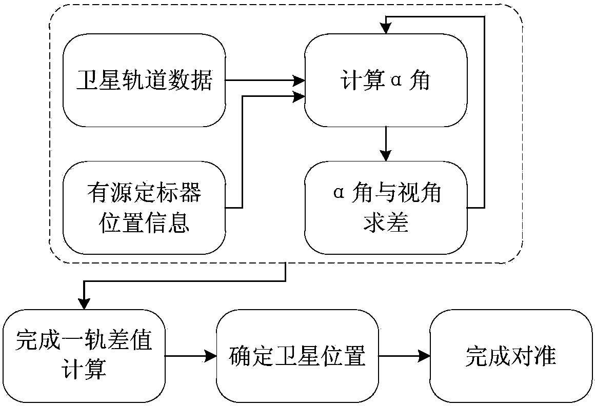
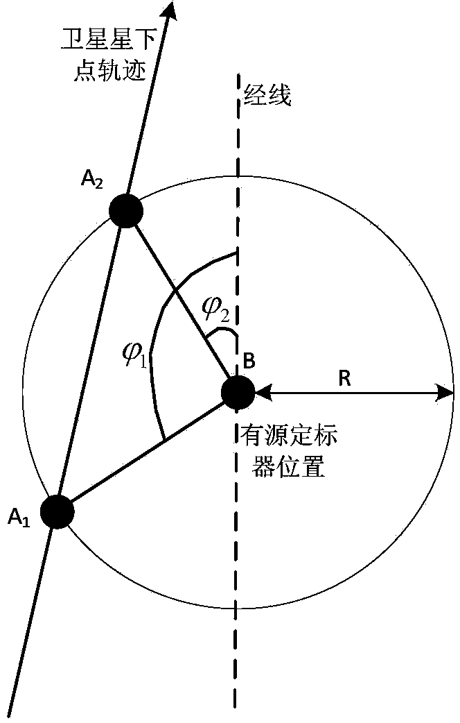
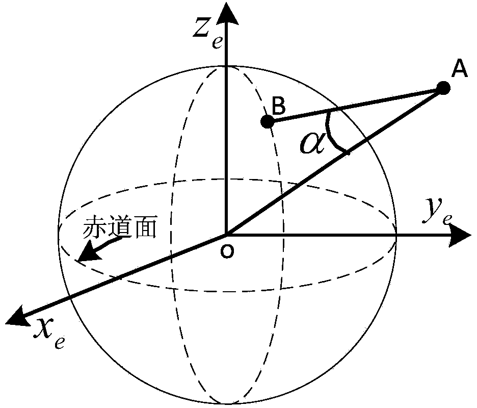
[0045] Such as figure 1 As shown, the method of the present invention uses the satellite orbit prediction data, the position and attitude information of the calibrator, and the satellite viewing angle, and when the angle between the satellite-earth center connection and the satellite-active calibrator connection and the satellite viewing angle difference are the smallest , based on the fact that the intersection point between the center of the satellite antenna beam and the earth is the closest to the active scaler, and the relevant knowledge of coordinate conversion is used to realize the alignment between the scaler and the satellite.

[0046] Specific steps are as follows:

[0047] (1) Establish the earth coordinate system, geographic coordinate system and carrier coordinate system;

[0048] The earth coordinate system uses ox e...


PUM


Abstract

Disclosed is a scaler and satellite pointing alignment determination method. The invention provides a novel design idea: when an included angle between a satellite-center of earth line and a satellite-active scaler line, and view angle difference of a satellite are the minimum, an intersection of the beam center of a satellite antenna with the earth is closest to an active scaler. The specific steps include: 1, establishing an earth coordinate system, a geographic coordinate system and a carrier coordinate system; 2, acquiring satellite orbit predicted data and active scaler positional information; 3, calculating a vector of the satellite-scaler line and the included angle alpha of the earth's center-satellite line; 4, locating the satellite; 5, converting the vector to the carrier coordinate system; 6, calculating azimuth psi and pitch angle theta of a scaler antenna relative to the scaler (carrier coordinate system); 7, controlling the antenna to rotate according to the two angles through a servo control system so as to align the scaler with the satellite. According to the coordinate transformation theory, the method has no approximate error and high alignment precision.

Description

technical field [0001] The invention relates to a method for determining alignment between a calibrator and a satellite, and belongs to the technical field of space microwave remote sensing. Background technique [0002] The active calibrator of the spaceborne microwave scatterometer is an equipment for on-orbit testing and calibration of the spaceborne microwave scatterometer, which is of great significance to ensure the continuity of microwave scatterometer observation tasks and the consistency of data standards. Determining the alignment method of the calibrator and the satellite pointing directly affects the success or failure of the active calibrator to the satellite test, and is a key point of the active calibrator. This method has been tested in practical application, and the field test of active scaler was successfully completed in the first half of 2013. [0003] At present, there is no public report on the alignment method of foreign satellite-borne microwave scat...

Claims


Application Information

Patent Timeline
Patent Type & Authority Applications(China)
IPC IPC(8): G01S7/40
CPCG01S7/40
Inventor 金阿鑫段崇棣薛强吕爱玲刘丽霞王小宁李浩谭小敏陈文新
Owner XIAN INSTITUE OF SPACE RADIO TECH
Why Eureka
Try Eureka