Simplified unmanned aerial vehicle multi-target location method

A multi-target positioning and unmanned aerial vehicle technology, applied in the field of photoelectric imaging measurement, can solve the problems of difficult real-time or quasi-real-time positioning of multiple targets, long time consumption, poor real-time performance, etc.

Inactive Publication Date: 2017-02-01
CHANGCHUN INST OF OPTICS FINE MECHANICS & PHYSICS CHINESE ACAD OF SCI
View PDF6 Cites 26 Cited by
  • Summary
  • Abstract
  • Description
  • Claims
  • Application Information

AI Technical Summary

Problems solved by technology

[0002] Generally, the UAV photoelectric platform uses an angle sensor to measure its own angle relative to the aircraft, and uses a laser rangefinder to output the distance between itself and the reticle pointing to the target relative to the center of the image. Combined with the aircraft's GPS position data and inertial navigation attitude data, the coordinate transformation method is used to realize Target positioning, when this positioning method based on the attitude measurement/laser ranging model is used to locate multiple targets, it is necessary to frequently change the spatial orientation of the photoel

Method used


Image

  • Simplified unmanned aerial vehicle multi-target location method
  • Simplified unmanned aerial vehicle multi-target location method
  • Simplified unmanned aerial vehicle multi-target location method

Examples


Embodiment Construction

[0036] The present invention will be described in detail below with reference to the accompanying drawings and examples.

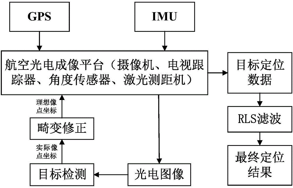
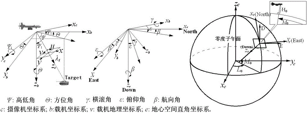
[0037] The invention provides a simplified UAV multi-target positioning method. By establishing a rigorous positioning geometric model, the distance and angle relationship between the target and the UAV photoelectric platform is calculated, and the single-frame image multi-target is realized through coordinate transformation. In order to solve the technical problems of complex hardware equipment, poor real-time performance and reliability caused by the existing multi-target positioning method based on the UAV multi-sensor platform.

[0038] The present invention is mainly aimed at the optoelectronic platform carried by small and medium-sized UAVs. It adopts a single-array CCD sensor to image the ground, and implements mid- and low-altitude flight reconnaissance. The ground coverage range of a single image is 1-2km, and in most cases there will not be too m...


PUM


Abstract

The present invention discloses a simplified unmanned aerial vehicle multi-target location method. The simplified unmanned aerial vehicle multi-target location method can perform location in real time while realizing multiple targets, and is simple in hardware device. An area array CCD camera is employed to perform grounding imaging, and obtaining the pixel coordinates of each target; performing distortion correction, and obtaining the ideal imaging points of each target; constructing the sight vectors of a main target, a sub target and a lower machine point in the camera coordinate systems; employing the coordinate transformation to obtain the sight vectors of the main target, the sub target and the lower machine point in the aerial carrier geographic coordinate system; calculating the coordinates of each target in the aerial carrier geographic coordinate system according to the distance from the main target and the sub target to a photoelectricity platform and the sight vectors of the main target and the sub target in the aerial carrier geographic coordinate system; and finally, obtaining the geodetic coordinates through the coordinate transformation, namely locating the result.

Description

technical field [0001] The invention relates to the technical field of photoelectric imaging measurement, in particular to a simplified multi-target positioning method for unmanned aerial vehicles. Background technique [0002] Generally, the UAV photoelectric platform uses an angle sensor to measure its own angle relative to the aircraft, and uses a laser rangefinder to output the distance between itself and the reticle pointing to the target relative to the center of the image. Combined with the aircraft's GPS position data and inertial navigation attitude data, the coordinate transformation method is used to realize Target positioning, when this positioning method based on the attitude measurement / laser ranging model is used to locate multiple targets, it is necessary to frequently change the spatial orientation of the photoelectric platform for multiple positioning, which consumes a long time and is difficult to implement real-time or Quasi-real-time positioning cannot a...

Claims


Application Information

Patent Timeline
IPC IPC(8): G06T7/70G06T7/246G06T7/254G06T7/11G06T7/12G06T5/00
CPCG06T5/006G06T2207/10004G06T2207/30212
Inventor 宋悦铭刘晶红刘成龙蔡明
Owner CHANGCHUN INST OF OPTICS FINE MECHANICS & PHYSICS CHINESE ACAD OF SCI
Why Eureka
Try Eureka