Road congestion recognition visualization method based on DBSCAN+

A road and cluster block technology, applied in the field of traffic big data, can solve problems such as the lack of a unified definition of traffic congestion, the verification of training and test sets, and the inability of data to be divided, and achieve the effect of real-time guarantee and fast clustering speed.

Active Publication Date: 2019-08-27
HUAIYIN INSTITUTE OF TECHNOLOGY
View PDF6 Cites 17 Cited by
  • Summary
  • Abstract
  • Description
  • Claims
  • Application Information

AI Technical Summary

Problems solved by technology

[0004] These commonly used traffic congestion detection methods are based on the idea of ​​extracting effective data from traffic data processing. In many cases, because traffic congestion detection does not have accurate results as a criterion, research

Method used


Image

  • Road congestion recognition visualization method based on DBSCAN+
  • Road congestion recognition visualization method based on DBSCAN+
  • Road congestion recognition visualization method based on DBSCAN+

Examples


Embodiment Construction

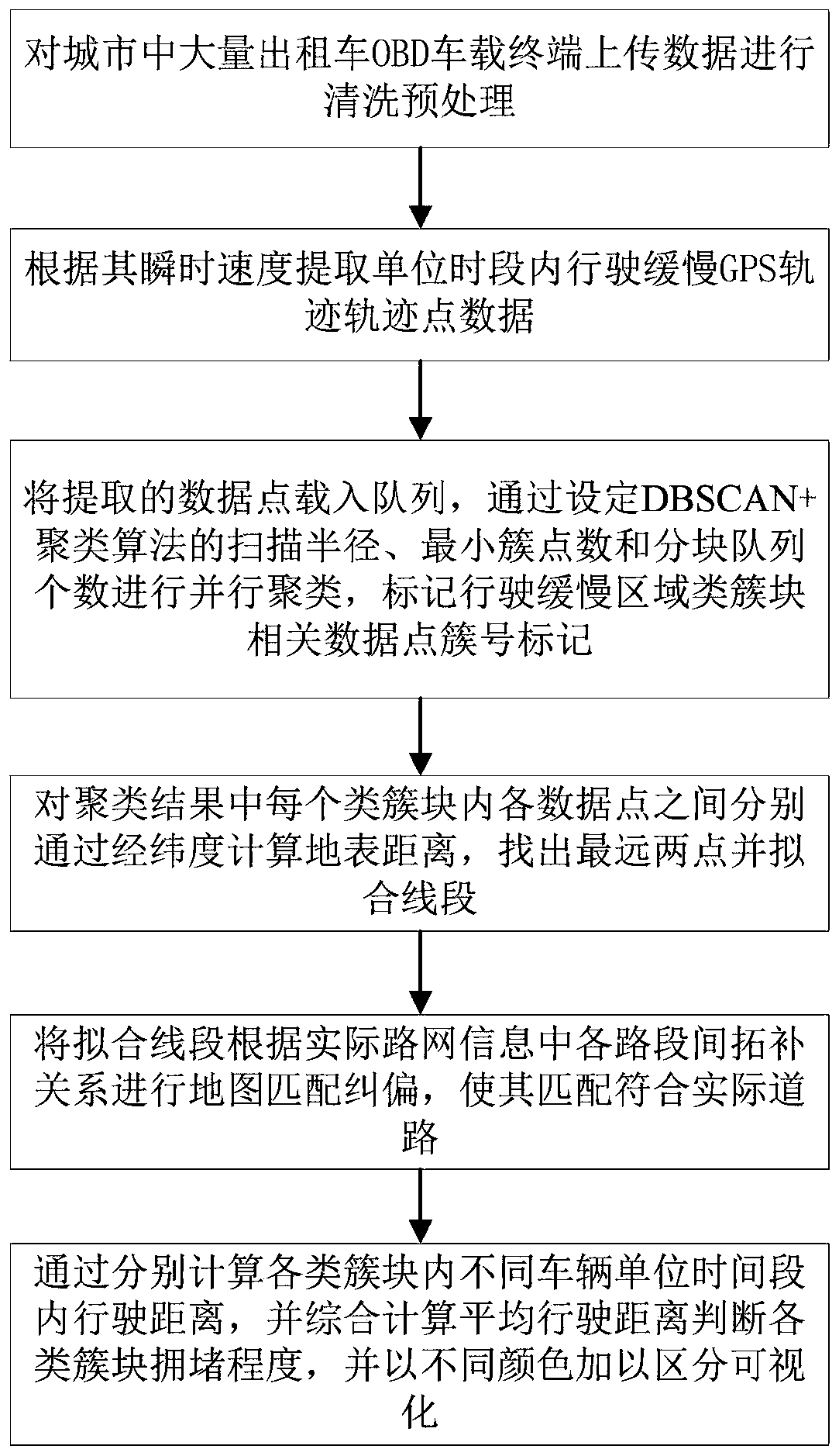
[0032] The present invention will be described in further detail below in conjunction with the accompanying drawings.

[0033] Such as figure 1 As shown, the road congestion recognition and visualization method based on DBSCAN+ includes the following steps:

[0034] (1) The on-board OBD (On-Board Diagnostics, on-board diagnostic system) terminal of the rental vehicle uploads data once every 20 seconds. The data includes: longitude, latitude, time stamp, vehicle identification number, passenger status and other information, and the urban taxi track is uploaded In the data set, clean the track data of zombies parked by the roadside, suspend operation but still uploaded, and judge whether the vehicle has moved within 5 minutes. When the displacement distance within 5 minutes is less than 10m, select and remove all trajectories of vehicles related to GPS track points satisfying the following formula from the queue to be clustered:

[0035]

[0036] In the formula, L represent...


PUM


Abstract

The invention discloses a road congestion recognition visualization method based on DBSCAN+. According to the method, first, a large amount of uploaded data of OBD vehicle terminals of floating cars in a city is preprocessed and cleaned; slow travel GPS track point data in a unit time period is extracted according to instantaneous velocities of the floating cars; DBSCAN+ algorithm parameters are set, and initial class cluster blocks in a slow travel region are acquired through parallel clustering of extracted data points; by calculating surface distances among all the data points in each classcluster block respectively, the two farthest points in each class cluster block are found out, and line segments are fitted; map-matching deviation rectification is performed on the fitted line segments according to a topological relation among all road segments in an actual road network; and last, by calculating travel distances of different vehicles in the unit time period in each class clusterblock respectively and calculating average travel distances synthetically, the congestion degrees of all the class cluster blocks are judged and expressed in different colors for differentiation andvisualization. The method can adapt to large-scale city taxi OBD terminal GPS track data, brings convenience to real-time recognition of city road congestion through taxi running conditions and achieves a good visualization effect.

Description

technical field [0001] The invention relates to the field of traffic big data, in particular to a road congestion identification and visualization method based on DBSCAN+ (Density-BasedSpatial Clustering of Applications with Noise Plus). Background technique [0002] With the increasingly serious problem of urban traffic congestion, establishing an effective road congestion identification system and accurately identifying traffic congestion sections in cities has become a current research direction. [0003] In the existing traffic jam detection technology, the traffic jam detection methods can be divided into the following categories according to the different processing methods of traffic data and the selected eigenvalues: (1) Based on the vehicle speed: some vehicles are directly detected by vehicle GPS The obtained vehicle speed data can be used directly after processing, or can be calculated from the time and mileage data of the vehicle. Xu L et al. used floating car d...

Claims


Application Information

Patent Timeline
IPC IPC(8): G08G1/01G06K9/62
CPCG08G1/0112G08G1/0125G06F18/2321
Inventor 高尚兵黄子赫郭若凡朱全银廖麒羽惠浩赵锋锋周君蔡创新郝阳明陈晓兵
Owner HUAIYIN INSTITUTE OF TECHNOLOGY
Why Eureka
Try Eureka