Floating car dynamic real-time traffic information processing method based on GPS data

An information processing method and a technology for GPS data, applied in the field of real-time processing of dynamic information of floating vehicles based on GPS data, can solve the problems of large amount of GPS data, large data interval, and inability to obtain calculation effects, and achieve high matching accuracy, satisfying Effects of Speed ​​Performance Requirements

Active Publication Date: 2008-09-24
北京交通发展研究院
View PDF0 Cites 81 Cited by
  • Summary
  • Abstract
  • Description
  • Claims
  • Application Information

AI Technical Summary

Problems solved by technology

[0009] 1. The data needs to be processed in real time, and the amount of data is large, so the calculation speed and performance of the system are required to be high;
[0010] 2. The data interval is generally large, resulting in poor correlation between the positioning point information;
[0011] 3. The road network in modern cities is dense and complex, so the matching fault tolerance rate of the system is high
[0012] These three difficulties make the above existing algorithms often unable to obtain ideal calculation results when applied to the real-time calculation system of floating vehicles in complex urban road networks
Point-to-point and point-to-line matching methods, the general algorithm is simple to meet the performance requirements of real-time computing speed, but it is often only suitable for large road networks with a simple structure such as the national expressway network, and will generate high traffic in urban areas with dense roads and complex structures. The matching error rate; and the line-to-line matching algorithm based on the trajectory curve, although the error tolerance rate is high and there are some mature algorithms that can be used for reference, but these algorithms need to obtain accurate trajectory curves as matching samples first, so they are only applicable to For high-density time-series data sets with a GPS collection interval of less than 5 seconds, for GPS track points with a collection interval of more than 1 minute, the gap between the two points before and after will reach 1-2 kilometers, and a very complicated urban road

Method used


Image

  • Floating car dynamic real-time traffic information processing method based on GPS data
  • Floating car dynamic real-time traffic information processing method based on GPS data
  • Floating car dynamic real-time traffic information processing method based on GPS data

Examples


Embodiment Construction

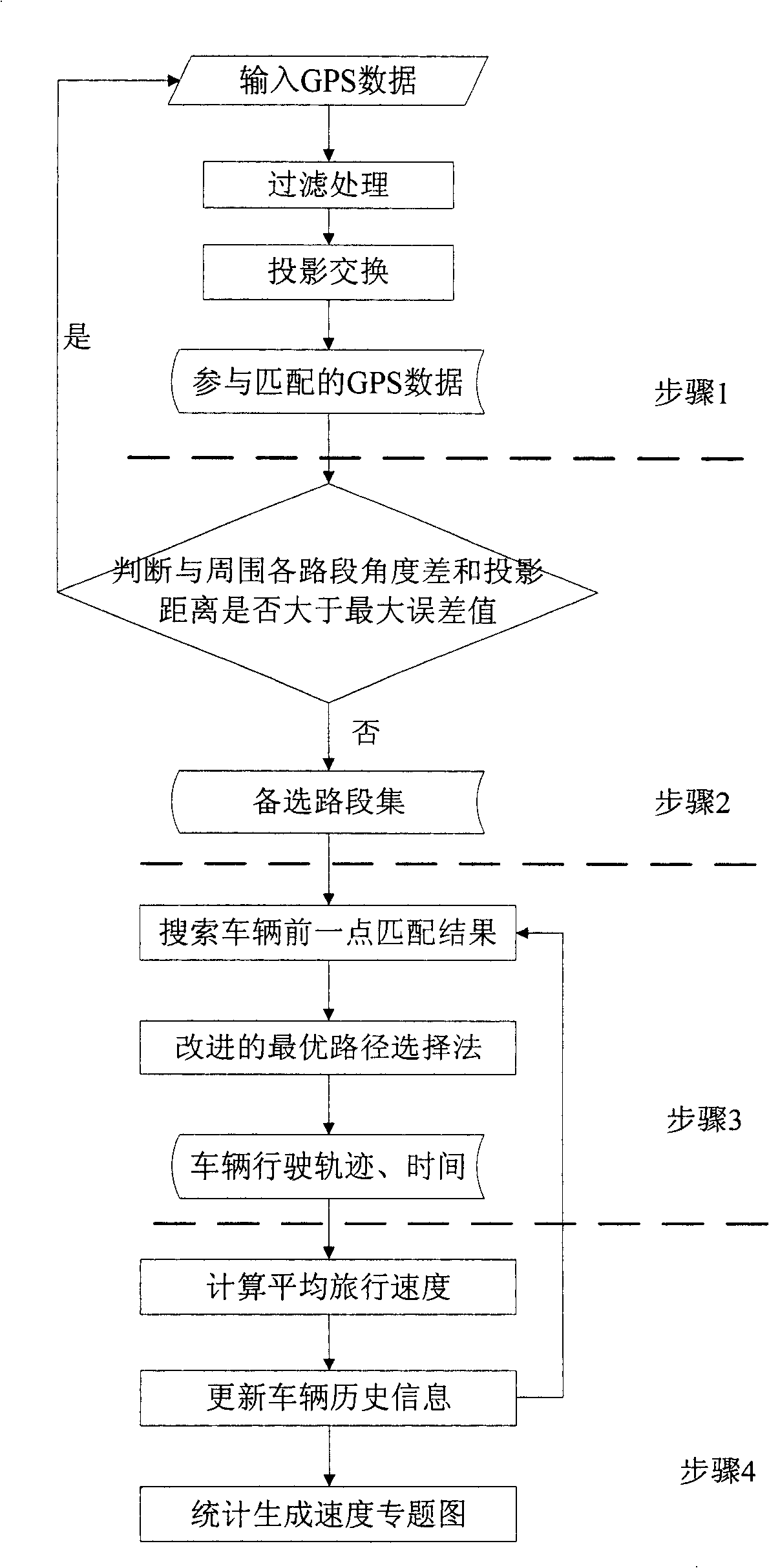
[0040] The present invention will be further described below in conjunction with the accompanying drawings and specific embodiments.

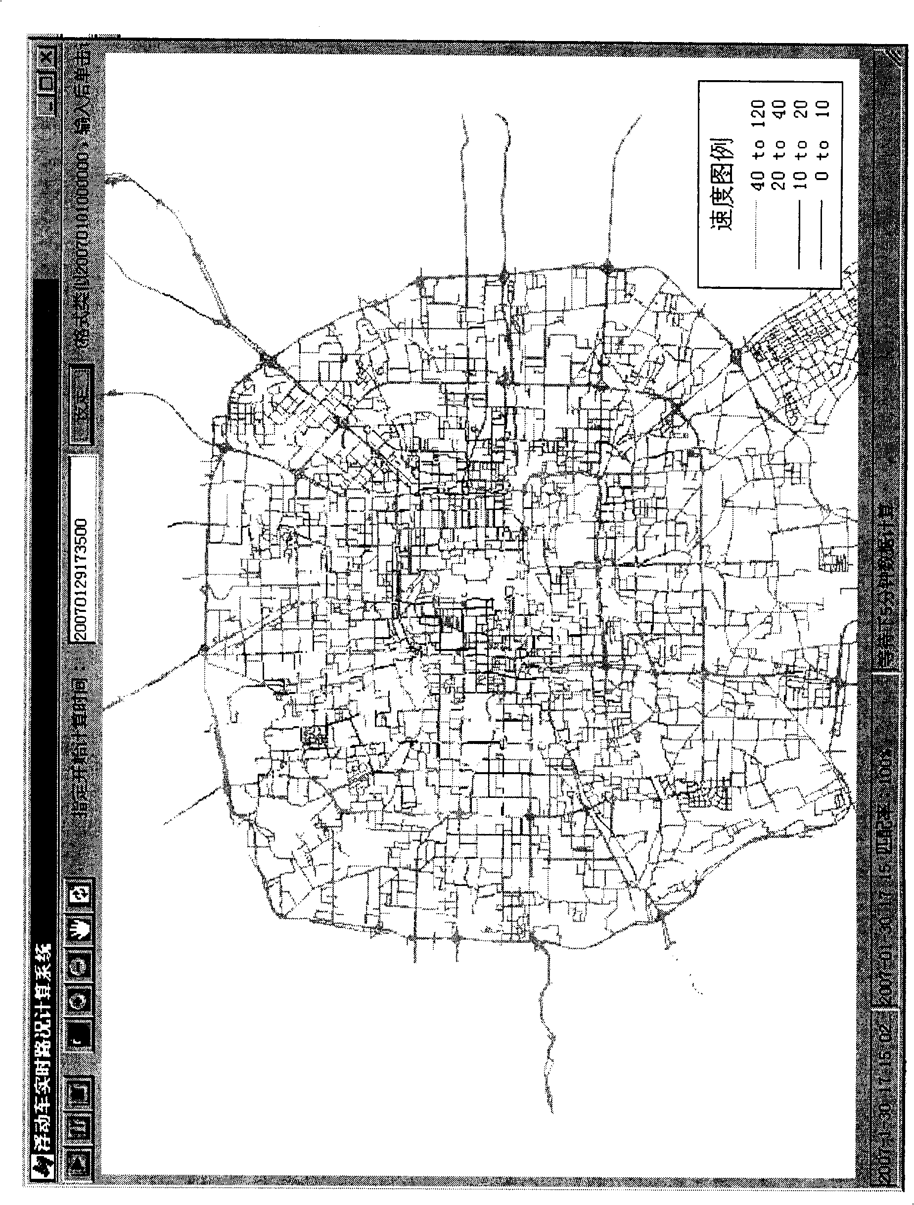
[0041] At present, the Beijing floating car system makes full use of the existing data acquisition system of the taxi security and dispatching system, obtains real-time GPS data of taxis by connecting to the existing taxi dispatching center, and performs real-time data processing in the computing center. At present, there are about 7,000 taxis involved in the calculation, accounting for more than 10% of the total number of taxis and 2.5% of the total number of motor vehicles. Each vehicle uploads one GPS point data about every minute, and the data content includes vehicle number, upload time, latitude and longitude coordinates, instantaneous speed, azimuth, operating status and other information. The floating car dynamic real-time traffic information processing system deployed in the data processing center takes 5 minutes as the calculation cyc...


PUM


Abstract

The invention discloses a floating car state real-time traffic information processing method based on GPS data, which includes the following steps: 1. GPS point data pre-processing and map pre-processing measures; 2. conduct point matching and select alternative road section sets according to projection distance and azimuth angles; 3. determine correct matching road sections and find out travel routes according to an improved optical route selection method considering topological relation between front and rear points (including a special regional node processing method for urban complicate road network); 4. calculate the route average travel speed, and conduct statistics in a speed formula to generate a road network speed thematic map. The floating car state real-time traffic information processing method based on GPS data of the invention is well applicable the modern complicated urban road network full of overpasses and staggered main and side roads, which can not only meet the speed requirement for large-data-quantity GPS data real-time calculation, but also obtain quite high matching precision.

Description

technical field [0001] The invention relates to the application field of intelligent transportation, in particular to a method for real-time processing of dynamic information of a floating car based on GPS data. Background technique [0002] With the development of society, the urban traffic flow is constantly increasing, and traffic congestion occurs from time to time. For this reason, it is very important to strengthen traffic management, and the key is to monitor the traffic status in real time. [0003] As a new traffic flow information collection technology, the floating car system has developed rapidly in big cities. Floating vehicles usually refer to vehicles with positioning and wireless communication devices. The floating vehicle system generally consists of three parts: on-board equipment, wireless communication network and data processing center. The floating car uploads the collected position and time data to the data processing center, which stores and preproc...

Claims


Application Information

Patent Timeline
IPC IPC(8): G01C21/26G01C21/30G01S5/00
Inventor 朱丽云全永燊温慧敏
Owner 北京交通发展研究院
Why Eureka
Try Eureka