GPS (Global Position System) spatio-temporal data increment road network real-time updating and trace matching system

A spatiotemporal data, real-time update technology, applied in the computer field, can solve the problems of low real-time performance, large amount of calculation, and the matching effect cannot meet the requirements of the production environment. Effect

Active Publication Date: 2017-06-13
济宁中科智能科技有限公司
View PDF7 Cites 80 Cited by
  • Summary
  • Abstract
  • Description
  • Claims
  • Application Information

AI Technical Summary

Problems solved by technology

[0004] CN201210327804.3-GPS terminal-based map matching method for vehicle position tracking, the method of curve fitting and multiple projections has a large amount of calculation, and the real-time performance is not high, and the curve fitting method has a matching effect on road sections such as overpasses and other special road sections Can not meet the requirements of the production environment

Method used


Image

  • GPS (Global Position System) spatio-temporal data increment road network real-time updating and trace matching system
  • GPS (Global Position System) spatio-temporal data increment road network real-time updating and trace matching system
  • GPS (Global Position System) spatio-temporal data increment road network real-time updating and trace matching system

Examples


Embodiment Construction

[0073] combined with Figures 1 to 3 The specific embodiment of the present invention is described further:

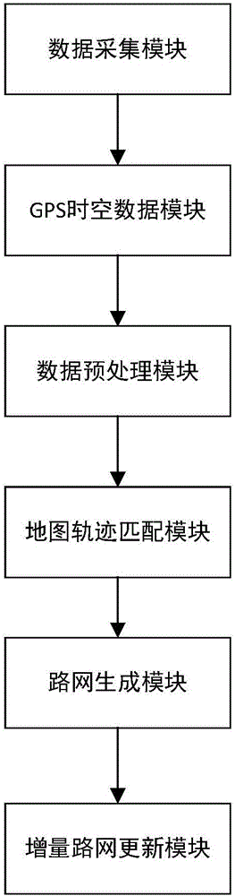
[0074] GPS spatiotemporal data incremental road network real-time update and trajectory matching system, including data acquisition module, GPS spatiotemporal data module, data preprocessing module, map trajectory matching module, road network generation module, and incremental road network update module.

[0075] The real-time update and trajectory matching system of GPS spatio-temporal data incremental road network includes the following steps in actual operation:

[0076] (1) Data collection:

[0077] The data acquisition module collects vehicle driving information in real time, and the GPS spatio-temporal data module collects data collected by GPS positioning equipment.

[0078] Remove the drift point information when driving or parking at low speed. When the vehicle is driving or parking at low speed, that is, when the speed value of the data collected by the GP...


PUM


Abstract

The invention discloses a GPS (Global Position System) spatio-temporal data increment road network real-time updating and trace matching system, which comprises a data acquisition module, a GPS spatio-temporal data module, a data pre-processing module, a map trace matching module, a road network generating module and an increment road network updating module. According to the system, the acquired data recorded by a GPS positioner and provided with time and space attributes is pre-processed, a map is matched, a road is generated, a newly formed road section is compared with road network data recorded in a database, road network information is updated, and thus road network data is updated. According to the GPS spatio-temporal data increment road network real-time updating and trace matching system provided by the invention, the road network information is compared continuously with incremental data information, so that a real-time capability is realized, road position information is more accurate along with the increment of data, and roads which are not contained in the road network information are updated.

Description

technical field [0001] The invention relates to the technical field of computers, in particular to a GPS space-time data incremental road network real-time update and trajectory matching system. Background technique [0002] In the prior art, the map trajectory matching technology mainly adopts the pattern recognition method, and more matches are performed on discrete location points. Although the accuracy is high, the real-time performance is not strong. The data collection process is to obtain GPS position data with time attributes from a large number of positioning devices, and display them on the map after simple data processing. This method may cause inaccurate applications such as GPS navigation due to unexpected factors such as weather and climate during the actual road data recording process, and at the same time, it cannot accurately and timely locate and update the newly added road conditions. [0003] CN201420519657.4-GPS real-time positioning and electronic map ...

Claims


Application Information

Patent Timeline
Patent Type & Authority Applications(China)
IPC IPC(8): G01C21/32G06F17/30
CPCG01C21/32G06F16/29
Inventor 李卫民张宝运单良王海滨穆范全
Owner 济宁中科智能科技有限公司
Why Eureka
Try Eureka