Indoor map automatic building method and system

A technology for automatic construction of indoor maps, applied in the directions of maps/plans/charts, measuring devices, instruments, etc., which can solve the problems of not considering how to process point cloud data, large workload, low precision, etc.

Pending Publication Date: 2019-09-24
奥孛睿斯有限责任公司
View PDF6 Cites 20 Cited by
  • Summary
  • Abstract
  • Description
  • Claims
  • Application Information

AI Technical Summary

Problems solved by technology

The traditional method is generally in the drawing software such as commonly used AutoCAD, MicroStation and other software, and the operator manually draws the external frame and internal wall of the building according to the measurement data, which requires a lot of work and low efficiency.
Just as the aforementioned patent document with the publication number CN 104897161 A provides a method for generating a planar grid map from a scanned point cloud, but it does not involve the extraction of building structures, but only rasterizes the scanned point cloud; However, the aforementioned literature (Ochmann, S., et al. "Automatic construction of parametric building models from indoor point clouds." 2016) proposed a method for extracting building geometry and parametric modeling

Method used


Image

  • Indoor map automatic building method and system
  • Indoor map automatic building method and system
  • Indoor map automatic building method and system

Examples


Embodiment Construction

[0088] The technical solutions of the present invention will be further described below in conjunction with the accompanying drawings and embodiments.

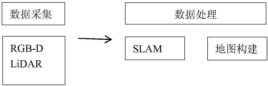
[0089] The present invention provides a method and system for automatically generating indoor floor plan grid maps and vector maps by using indoor building environment data collected by equipment including professional and consumer equipment. The following will be divided into two parts to illustrate the technical content of the indoor map automatic construction method and system of the present invention respectively:

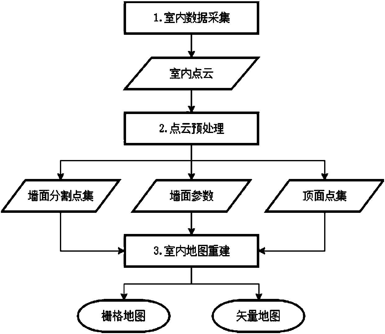
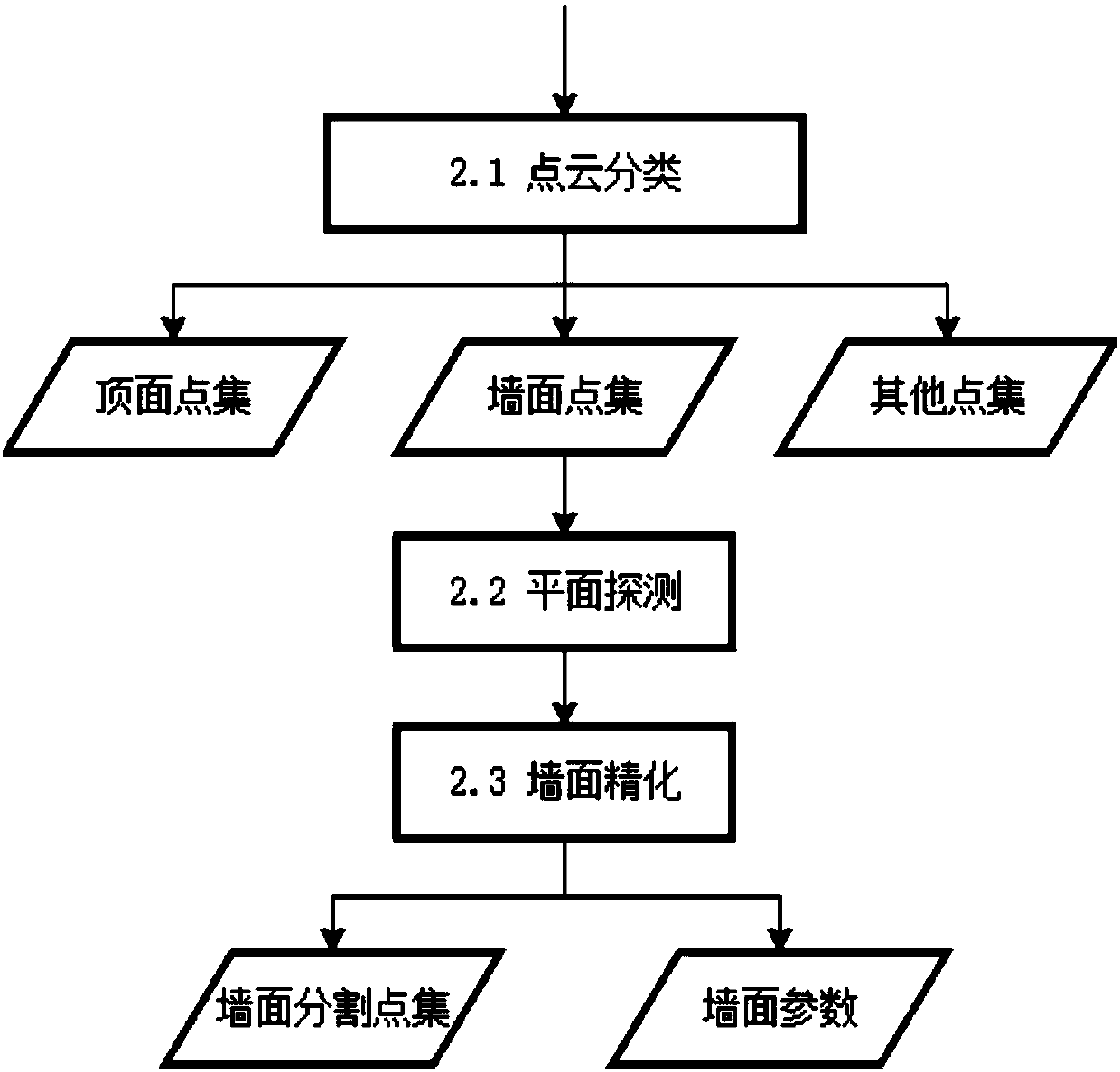
[0090] This embodiment provides a method for automatically constructing an indoor map, that is, a method for automatically constructing an indoor floor plan grid map and a vector map. Indoor environment point cloud data collected by Phone or other professional-grade equipment; classify the point cloud data to obtain at least three types of points belonging to the building wall, points belonging to the top surfa...


PUM


Abstract

The invention discloses an indoor map automatic building method and system. The system includes a data acquisition module which acquires point cloud data of indoor environment, a point cloud preprocessing module which extracts a geometric structure of the indoor environment from the point cloud data of indoor environment, a map building module which automatically builds an indoor raster map or an indoor vector map, and an output module which outputs the built map. The indoor map automatic building method and system can effectively utilize the three-dimensional point cloud data of indoor scene collected by consumption-grade RGB-D equipment to extract the geometric structure of the inside of a building by an automatic method and generate the plane raster map and the vector map of the inside of the building, which can solve the problem of conventional indoor map making, improve the efficiency of indoor mapping and reduce the cost of the indoor mapping.

Description

technical field [0001] The present invention relates to the technical field of indoor surveying and mapping, in particular to a method and system for automatically constructing indoor grid maps and vector maps based on point cloud data collected by consumer grade RGB-D sensors or LiDAR sensors. Background technique [0002] The indoor environment is the main scene of human production and life. Location-based services (Location-Based Service) for indoor environments, including but not limited to airport terminals, shopping centers, gymnasiums, art galleries, warehouses, and indoor parking lots, are currently widely used. It has become an important technical support for many emerging business service models, such as indoor navigation, target positioning, advertising and promotion, etc. The floor plan is the basis of indoor location services, and the most direct way to obtain it is to digitize architectural planning / design drawings. [0003] Due to management problems, or even...

Claims


Application Information

Patent Timeline
IPC IPC(8): G01C21/32G01C21/20G09B29/00
CPCG01C21/32G01C21/206G09B29/005
Inventor 贺喆张靖
Owner 奥孛睿斯有限责任公司
Why Eureka
Try Eureka