
Unmanned aerial vehicle assisted wireless sensor network data collection method

A wireless sensor and network data technology, applied in radio transmission system, network topology, wireless communication and other directions, can solve the problem of low value of data information, and achieve the effect of prolonging network life, low cost and easier to achieve

Active Publication Date: 2019-10-11
SOUTHEAST UNIV
View PDF5 Cites 13 Cited by
  • Summary
  • Abstract
  • Description
  • Claims
  • Application Information

AI Technical Summary

Problems solved by technology

This information is time-sensitive, the later the drone collects, the lower the value of the data information

Method used


Image

  • Unmanned aerial vehicle assisted wireless sensor network data collection method
  • Unmanned aerial vehicle assisted wireless sensor network data collection method
  • Unmanned aerial vehicle assisted wireless sensor network data collection method

Examples


Embodiment Construction

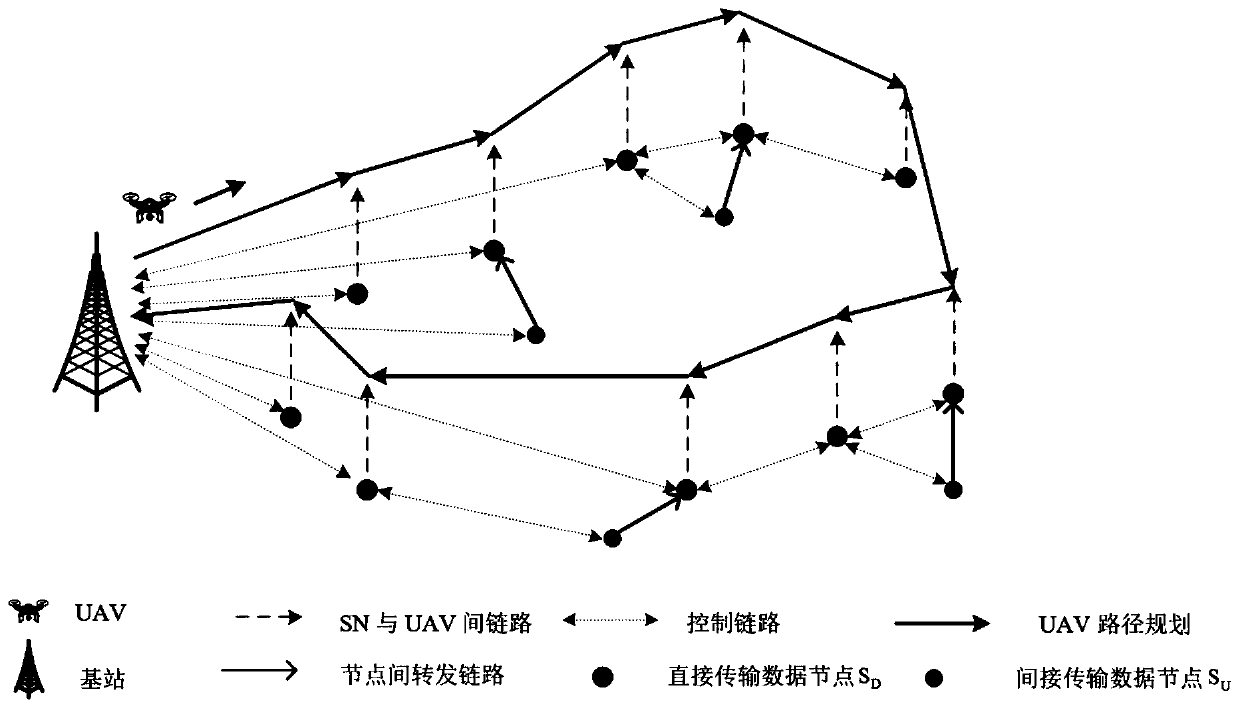
[0038] The invention is applied to UAV-aided WSNs, considering the path length limitation of UAVs, and minimizing the energy consumed by nodes while maximizing the value of data information through the idea of ​​layered optimization. The implementation method of the present invention will be further described below in conjunction with the accompanying drawings.

[0039] as attached figure 1 As shown, the applicable sensorless network consists of sensor node set S={s i |i=1,2,...,n} and a UAV. Sensor nodes are randomly distributed in the target area, assuming their locations are known due to manual deployment or localization systems. Different types of sensor nodes can collect different types of information, such as temperature, humidity, pictures, remote sensing information, etc. These data vary in size and information value. Each node hopes to transmit the collected data back to the base station, but due to the distance between the base station and the node, direct transm...


PUM


Abstract

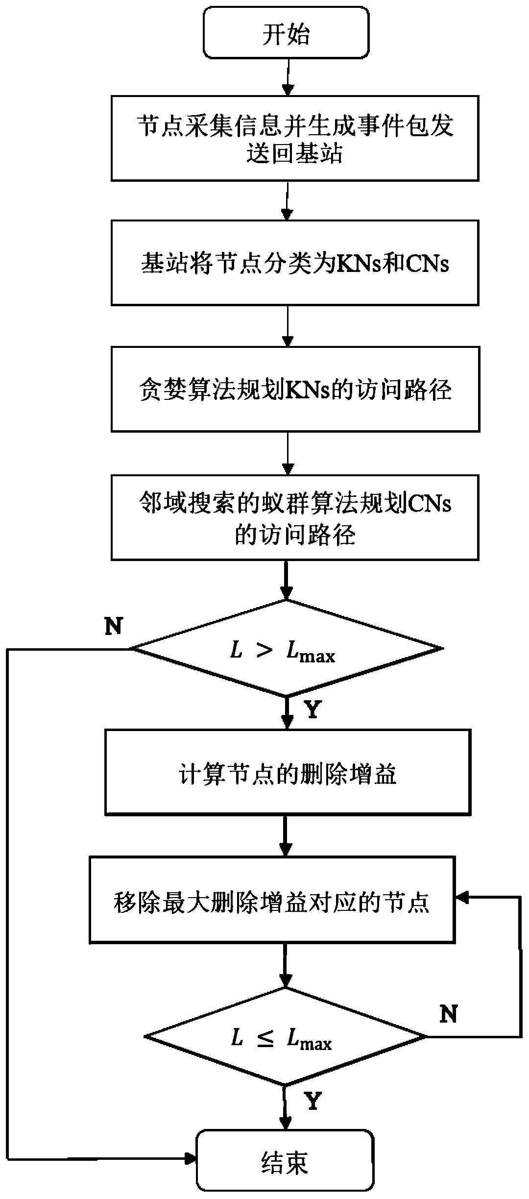
The invention discloses an unmanned aerial vehicle-assisted wireless sensor network data collection method, which comprises the following steps that: (1) sensor nodes collect information in a communication range, generate corresponding event packets and send the event packets back to a base station; (2) a base station classifies the nodes of which the information value attenuation indexes are notzero as key nodes, and classifies the nodes of which the information value attenuation indexes are zero as common nodes; (3) access paths of all key nodes are planned by adopting a greedy algorithm according to the geographic positions of the nodes; (4) access paths of all common nodes are planned by adopting an ant colony algorithm of neighborhood search according to geographic positions of the nodes; (5) the total length of the path is calculated and whether the total length of the path is greater than the maximum flight length of the unmanned aerial vehicle is judged; (6) if so, the deletion gain of each common node is calculated, nodes corresponding to the maximum deletion gain are removed in the path, and the step (5) is executed; if not, the step (7) is executed; and (7) an unmannedaerial vehicle sequentially collects data of the sensor nodes according to the planned path. The method is low in energy consumption and simple in structure.

Description

technical field [0001] The invention relates to a wireless sensor network, in particular to a UAV-assisted wireless sensor network data collection method. Background technique [0002] Wireless sensors are widely deployed due to their low cost, long life, and small size, and are mainly used in farmland monitoring, disaster relief, and animal tracking. However, when the number of nodes increases and the monitoring scale becomes larger, the network is prone to problems such as large delays and coverage holes. To improve these problems, drones are introduced into wireless sensor networks. [0003] There are three main applications of drones in wireless sensor networks. The first application is based on the ubiquitous coverage of drones. When the base station fails or is unavailable, drones provide seamless wireless coverage for the network. The second application is based on the relay function of the drone, where the drone can provide an indirect connection between any two re...

Claims


Application Information

Patent Timeline
IPC IPC(8): H04W4/38H04W40/02H04W40/20H04W84/18H04B7/185G08C17/02G01S5/02
CPCH04W4/38H04W40/02H04W40/20H04W84/18H04B7/18506G08C17/02G01S5/0278Y02D30/70
Inventor 燕锋陈佳慧茅珅珅夏玮玮沈连丰胡静宋铁成
Owner SOUTHEAST UNIV
Learn More