Point cloud and grid partitioning method in aerial photography terrain three-dimensional reconstruction system

A technology of 3D reconstruction and triangular mesh, which is applied in 3D image processing, image data processing, instruments, etc., can solve problems such as the failure to generate DOM and DSM normally, excessive data volume, etc., and achieve good intra-block and inter-block relationships , lower the hardware threshold, and reduce the effect of merging errors

Pending Publication Date: 2019-10-25
西安因诺航空科技有限公司
View PDF3 Cites 12 Cited by
  • Summary
  • Abstract
  • Description
  • Claims
  • Application Information

AI Technical Summary

Problems solved by technology

The existing method has the problem that DOM and DSM cannot be generated normally due to the large amount of data in 2D map stitching and 3D terrain reconstruction of aerial photography large scenes

Method used


Image

  • Point cloud and grid partitioning method in aerial photography terrain three-dimensional reconstruction system
  • Point cloud and grid partitioning method in aerial photography terrain three-dimensional reconstruction system
  • Point cloud and grid partitioning method in aerial photography terrain three-dimensional reconstruction system

Examples


Embodiment Construction

[0031] The present invention is further described below in conjunction with accompanying drawing:

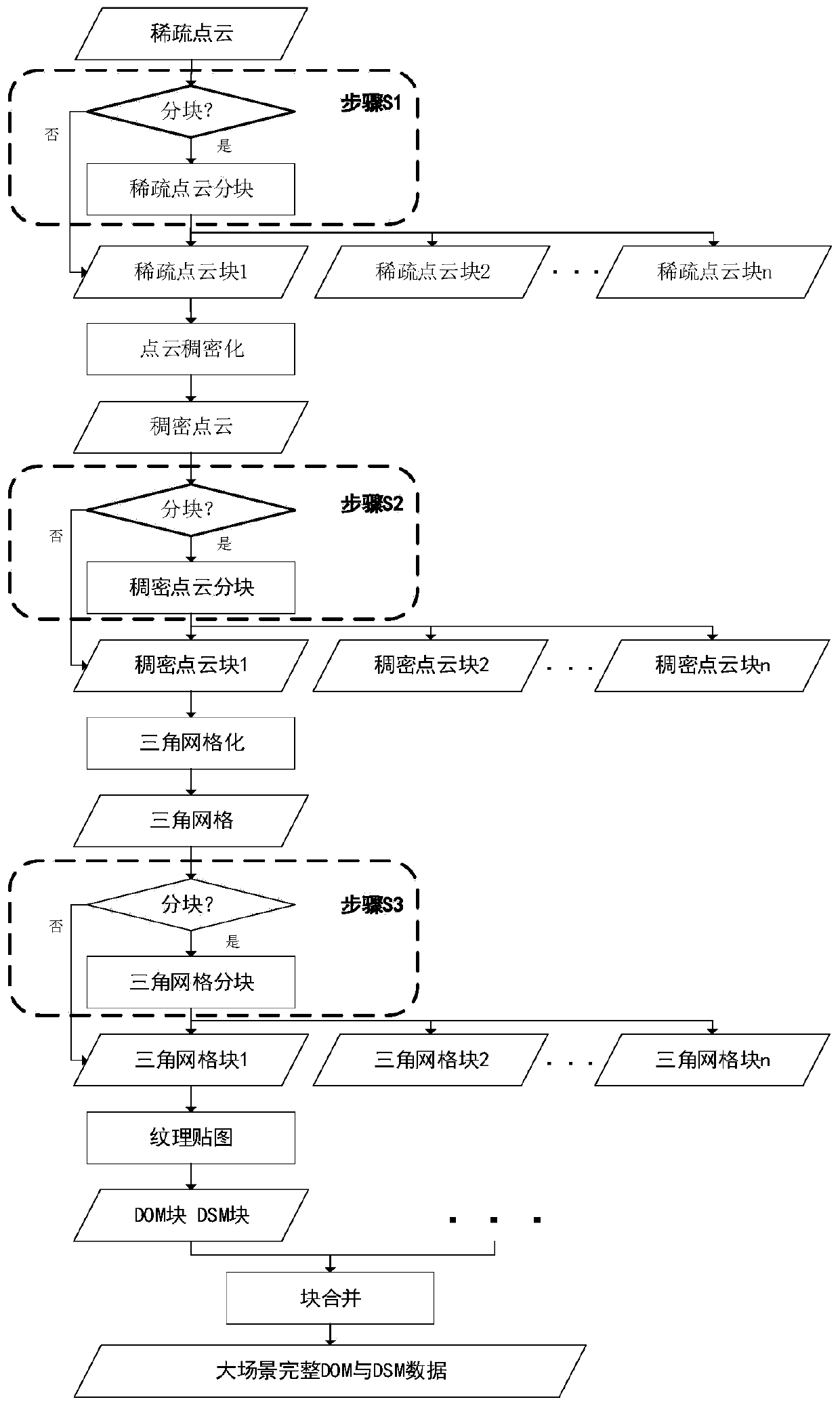
[0032] see Figure 1 to Figure 5 A method for segmenting point clouds and grids in an aerial terrain three-dimensional reconstruction system, comprising the following steps:

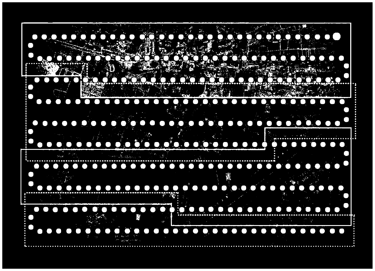
[0033] Step 1: In the 3D reconstruction system, use SLAM or SfM technology to estimate the sparse point cloud of the camera pose and scene through nonlinear optimization, divide the sparse point cloud into blocks, and densify the sparse point cloud after the block operate;

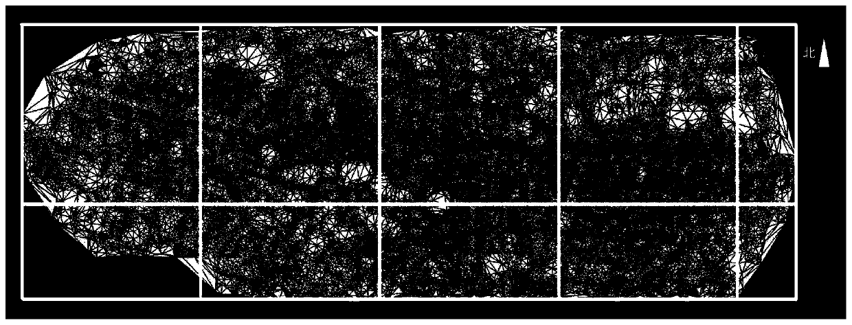
[0034] Step 2: After the point cloud densification is completed, the dense point cloud is divided into blocks, and after the dense point cloud is divided into blocks, the dense point cloud is triangulated and meshed;

[0035] Step 3: After the triangular mesh is obtained, the triangular mesh is divided into blocks before the texture map processing, so as to realize the requirement of generating large-resolution DOM and DSM images.

...


PUM


Abstract

The invention discloses a point cloud and grid partitioning method in an aerial photography terrain three-dimensional reconstruction system. According to the method, the problem that important modulessuch as point cloud densification, triangular gridding and texture mapping in a three-dimensional reconstruction system cannot be processed due to large data volume of point cloud is solved by partitioning three-dimensional data generated by aerial photography of large-scale scene terrain. According to the method, layer-by-layer segmentation is carried out on three-dimensional data in stages according to the memory use condition in a module, point cloud is partitioned before point cloud densification and triangular meshing, and then triangular meshes are partitioned before texture mapping processing. The hardware threshold of operation of a three-dimensional reconstruction system is reduced, the intra-block and inter-block relationship after partitioning can be well reserved, and a solidfoundation is laid for generating a large-scene high-resolution digital orthoimage (DOM) and a digital surface model (DSM).

Description

technical field [0001] The invention belongs to the application field of unmanned aerial photography data, and in particular relates to a point cloud and grid block method in an aerial photography terrain three-dimensional reconstruction system. Background technique [0002] With the country's strict control over drone airspace, the safety and stability of industrial drones have been greatly improved. Immediately after that, industrial-level applications based on drones emerged in an endless stream, among which aerial surveying and mapping and industrial inspection were the most prominent. These applications all have the requirements of large-scene 2D map stitching and 3D terrain reconstruction. However, due to the characteristics of high image resolution and large number of images in such projects, the realization of scene reconstruction not only depends more on the hardware performance of the PC platform, but also Higher requirements are also put forward for the algorithm...

Claims


Application Information

Patent Timeline
Patent Type & Authority Applications(China)
IPC IPC(8): G06T19/20G06T15/04
CPCG06T19/20G06T15/04
Inventor 马泳潮雍旭东
Owner 西安因诺航空科技有限公司
Why Eureka
Try Eureka