A Satellite Remote Sensing Estimation Method of PM2.5 Concentration in Polluted Weather

A technology for polluted weather and satellite remote sensing, applied in the field of remote sensing, can solve problems such as missing data, inaccurate estimation, and discontinuous time, and achieve the effects of fast speed, accurate data support, and high precision

Active Publication Date: 2021-03-09
INST OF REMOTE SENSING & DIGITAL EARTH CHINESE ACADEMY OF SCI +2
View PDF15 Cites 0 Cited by
  • Summary
  • Abstract
  • Description
  • Claims
  • Application Information

AI Technical Summary

Problems solved by technology

[0003] At present, the research on PM2.5 concentration mainly includes ground observation and remote sensing inversion. Among them, ground observation mainly includes offline sample collection and real-time online sample detection, but the coverage of ground monitoring stations is low and the time is not long. Continuous, difficult to conduct long-term and large-scale research
Satellite remote sensing methods can effectively solve these problems, because aerosol optical depth has a strong correlation with PM2.5 concentration, so the remote sensing estimation method based on aerosol optical depth is widely used in the estimation of PM2.5 concentration. There are many remote sensing estimation methods for PM2.5 concentration, but when the PM2.5 concentration is high, the estimation effect is not ideal, and problems such as missing data and inaccurate estimation often occur. Therefore, remote sensing of PM2.5 concentration in polluted weather Estimates are not perfect, there are still many problems

Method used


Image

  • A Satellite Remote Sensing Estimation Method of PM2.5 Concentration in Polluted Weather
  • A Satellite Remote Sensing Estimation Method of PM2.5 Concentration in Polluted Weather
  • A Satellite Remote Sensing Estimation Method of PM2.5 Concentration in Polluted Weather

Examples


Embodiment Construction

[0043] In order to make the object, technical solution and advantages of the present invention clearer, the present invention will be further described in detail below in combination with specific embodiments and with reference to the accompanying drawings. It should be understood that these descriptions are exemplary only, and are not intended to limit the scope of the present invention. Also, in the following description, descriptions of well-known structures and techniques are omitted to avoid unnecessarily obscuring the concept of the present invention.

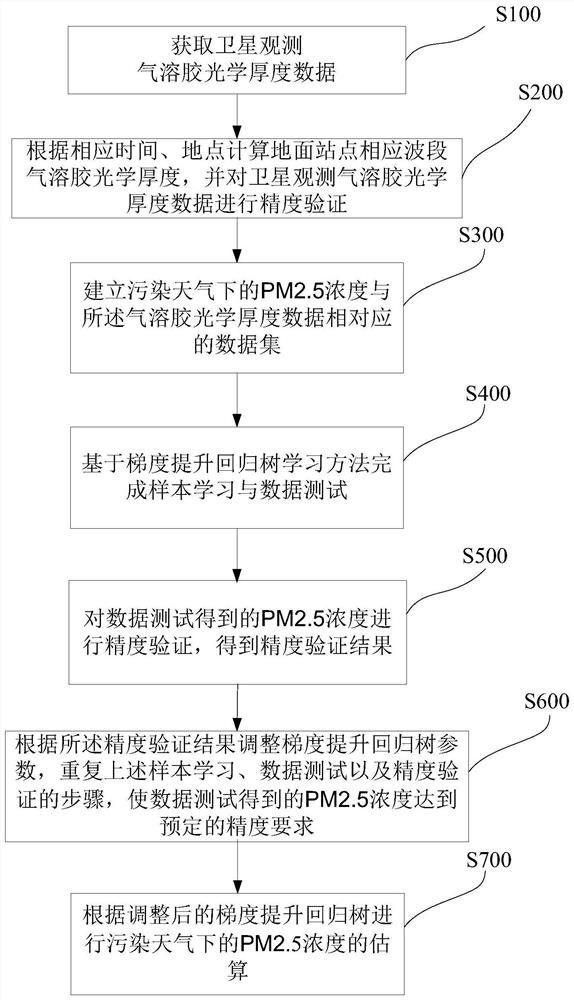
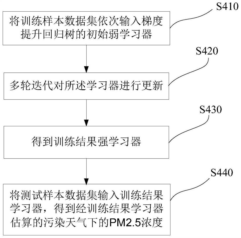
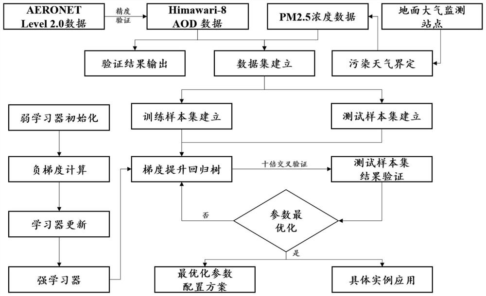
[0044] The invention provides a method for satellite remote sensing estimation of PM2.5 concentration under polluted weather, and the PM2.5 concentration is selected to be greater than 75 μg / m 3The weather in is represented as polluted weather. The present invention chooses to use the gradient boosting regression tree algorithm to estimate the PM2.5 concentration based on the aerosol optical thickness in polluted weather...


PUM


Abstract

A method for satellite remote sensing estimation of PM2.5 concentration under polluted weather, which uses satellite aerosol optical depth data and corresponding ground PM2.5 concentration data to establish a data set, and completes sample learning and data testing based on gradient boosting regression tree learning method. The accuracy of the test results is verified, and the parameters of the gradient boosting regression tree are adjusted to meet the accuracy requirements. The final calculation model of the regression tree can be effectively used for PM2.5 concentration estimation in polluted weather, and the results are more accurate. The estimation speed is faster, which can supplement the insufficiency of traditional methods for PM2.5 concentration estimation in polluted weather, and provide more accurate data support for air pollution prevention and control.

Description

technical field [0001] The invention relates to the technical field of remote sensing, in particular to a satellite remote sensing estimation method for PM2.5 concentration in polluted weather. Background technique [0002] With the sustained and rapid development of my country's industrialization and urbanization, people's living standards have risen sharply, and more and more environmental problems have also emerged. In recent years, large-scale continuous smog has occurred in China many times. The smog is mainly composed of PM2.5, which can enter the lungs. PM2.5 refers to particles with an aerodynamic diameter of less than 2.5 μm. Compared with PM10, PM2.5 has a smaller particle size and can be absorbed in the atmosphere Long-term stay and long-distance transmission have a greater impact on the quality of the air environment; PM2.5 is easy to attach to various toxic and harmful substances (such as persistent organic pollutants, heavy metals, various pathogenic bacteria, ...

Claims


Application Information

Patent Timeline
Patent Type & Authority Patents(China)
IPC IPC(8): G01N15/02G06N20/00
CPCG01N15/0205G06N20/00
Inventor 顾行发左欣程天海郭红余涛师帅一
Owner INST OF REMOTE SENSING & DIGITAL EARTH CHINESE ACADEMY OF SCI
Why Eureka
Try Eureka