AGV positioning system and method for fusing 2D environmental map and sparse artificial landmark

A technology of artificial landmarks and environmental maps, applied in control/adjustment systems, two-dimensional position/channel control, vehicle position/route/height control, etc., can solve the problem of decreased positioning accuracy of artificial landmarks, increased navigation costs, and insufficient positioning accuracy Satisfaction and other issues

Active Publication Date: 2019-10-29
HANGZHOU DIANZI UNIV
View PDF4 Cites 34 Cited by
  • Summary
  • Abstract
  • Description
  • Claims
  • Application Information

AI Technical Summary

Problems solved by technology

The current common laser SLAM positioning is limited by the computing power of the computer and the minimum resolution of the probability map, so the positioning accuracy cannot meet the requirements of some industrial scenarios that require high-precision positioning, and in some environments that are relatively open and beyond the scanning range of the laser radar. The lower laser SLAM cannot complete the positioning that meets the motion control requirements, and the artificial landmark positioning needs to add a large number of artificial landmarks in the environment, which increases the cost of navigation, and when the laser radar of the AGV vehicle is installed at a lower height, the artificial landmarks are easily blocked. This leads to a decrease in positioning accuracy

Method used


Image

  • AGV positioning system and method for fusing 2D environmental map and sparse artificial landmark
  • AGV positioning system and method for fusing 2D environmental map and sparse artificial landmark
  • AGV positioning system and method for fusing 2D environmental map and sparse artificial landmark

Examples


Embodiment Construction

[0077] The technical solution of the present invention will be further described in detail below in conjunction with the accompanying drawings, but the protection scope of the present invention is not limited to the following description.

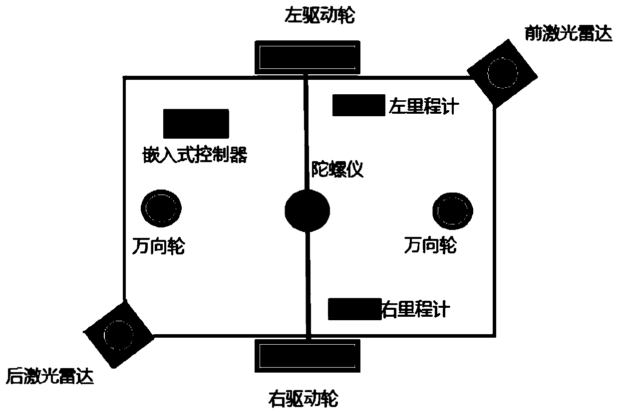
[0078] The present invention provides an AGV high-precision positioning system that integrates 2D environmental maps and sparse artificial landmarks. The system includes vehicle-mounted equipment and artificial landmarks arranged in the work scene; the vehicle-mounted equipment includes two laser radars, gyroscopes, and mileage Meter and positioning unit, taking the differential wheel driven AGV as an example, such as figure 1 As shown, the lidar must be installed on two opposite corners of the car body to ensure that the lidar scanning points can cover the surrounding of the car body. The gyroscope needs to be installed at the midpoint of the connection between the two driving wheels of the AGV.

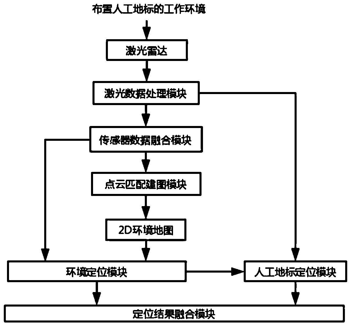
[0079] Such as figure 2 Shown is a sche...


PUM


Abstract

The present invention discloses an AGV positioning system and method for fusing a 2D environmental map and a sparse artificial landmark. The system comprises a vehicle-mounted device, an artificial landmark, and a 2D environmental map. The 2D environmental map is established by the vehicle-mounted device according to a current environment. The artificial landmark comprises position information andnumber information. Each artificial landmark is uniquely numbered in the environmental map. The vehicle-mounted device comprises a laser radar, a milemeter, a gyroscope, and a positioning unit. The positioning unit comprises a laser data processing module, a sensor data storage module, a point cloud matching graph construction module, an environment positioning module, an artificial landmark positioning module, and a positioning result fusing module. The point cloud matching graph construction module is used for graph construction. After the 2D environmental map is obtained, the environment positioning module and the artificial landmark positioning module are used for obtaining a positioning result. Finally, the positioning result fusing module is used for fusing positioning results and providing final positioning information, so that high-precision positioning of an AGV car in environment is implemented.

Description

technical field [0001] The invention belongs to the field of automatic control, and in particular relates to an AGV positioning system and method for integrating 2D environment maps and sparse artificial landmarks. Background technique [0002] At present, automatic guided vehicles have become important equipment for enterprise internal logistics, smart factories, and advanced logistics, and play a very important role in improving the automation, informatization and intelligence of enterprise internal logistics. The premise of automatic guidance and automatic material handling is that the vehicle can be accurately positioned. The current common laser SLAM positioning is limited by the computing power of the computer and the minimum resolution of the probability map, so the positioning accuracy cannot meet the requirements of some industrial scenarios that require high-precision positioning, and in some environments that are relatively open and beyond the scanning range of th...

Claims


Application Information

Patent Timeline
Patent Type & Authority Applications(China)
IPC IPC(8): G05D1/02
CPCG05D1/0257G05D1/0231G05D1/0272G05D1/027
Inventor 王赓林志赟韩志敏
Owner HANGZHOU DIANZI UNIV
Why Eureka
Try Eureka