Aircraft fault tolerant navigation estimation method of analytic redundancy

An analytical, aircraft technology, applied in the field of navigation, can solve the problems of GPS signal loss, performance degradation and failure of airborne navigation sensors

Active Publication Date: 2019-11-08
NANJING UNIV OF AERONAUTICS & ASTRONAUTICS
View PDF7 Cites 7 Cited by
  • Summary
  • Abstract
  • Description
  • Claims
  • Application Information

AI Technical Summary

Problems solved by technology

However, in some special environments, the performance of the airborne navigation sensor decreases or even fails. For example, acoustic wave interference will destroy the performance of the IMU, and urban occlusion will cause the loss of GPS signals, etc.
If a faulty sensor is used to participate in the navigation calculation, it will cause the aircraft to lose control or even crash

Method used


Image

  • Aircraft fault tolerant navigation estimation method of analytic redundancy
  • Aircraft fault tolerant navigation estimation method of analytic redundancy
  • Aircraft fault tolerant navigation estimation method of analytic redundancy

Examples


Embodiment Construction

[0196] The technical solution of the present invention will be described in detail below in conjunction with the accompanying drawings.

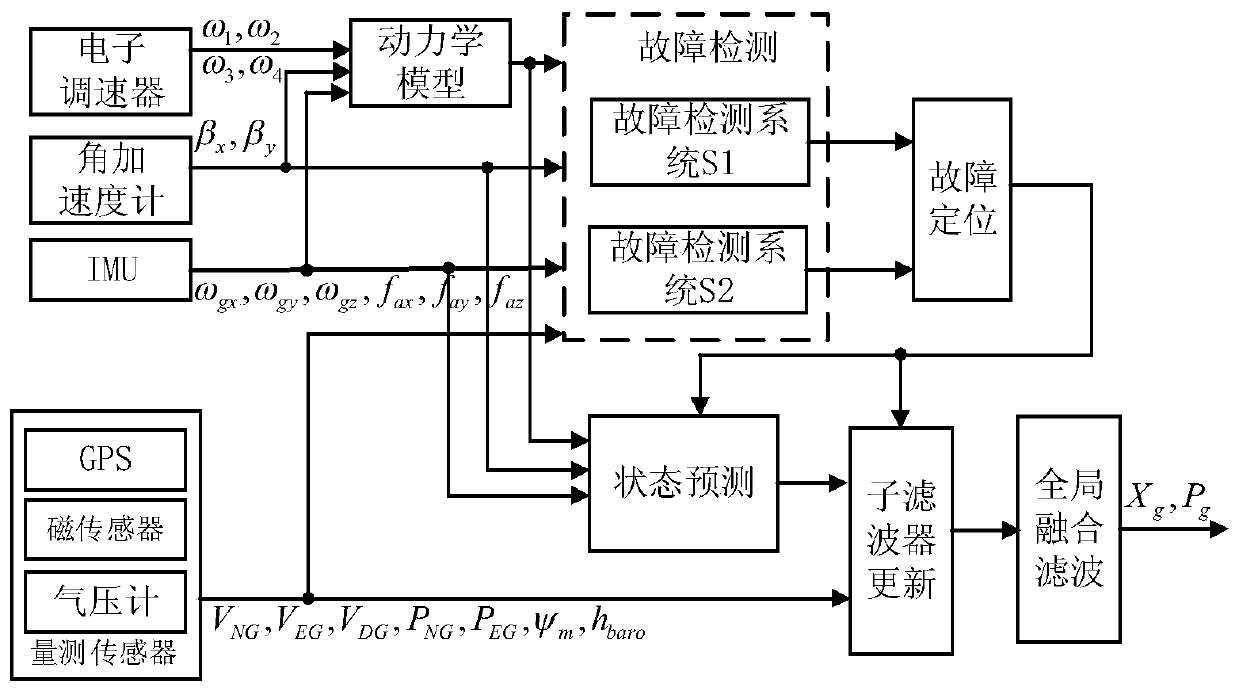
[0197] The present invention designs an analytical redundant aircraft fault-tolerant navigation estimation method, such as figure 1 As shown, including the following steps:

[0198] Step 1: Periodically read the output of the rotor speed measurement system, angular accelerometer, IMU, magnetic sensor, GPS and barometer of the carrier at time k, and estimate the motion acceleration information and angular acceleration of the rotorcraft through the dynamic model of the rotorcraft information;

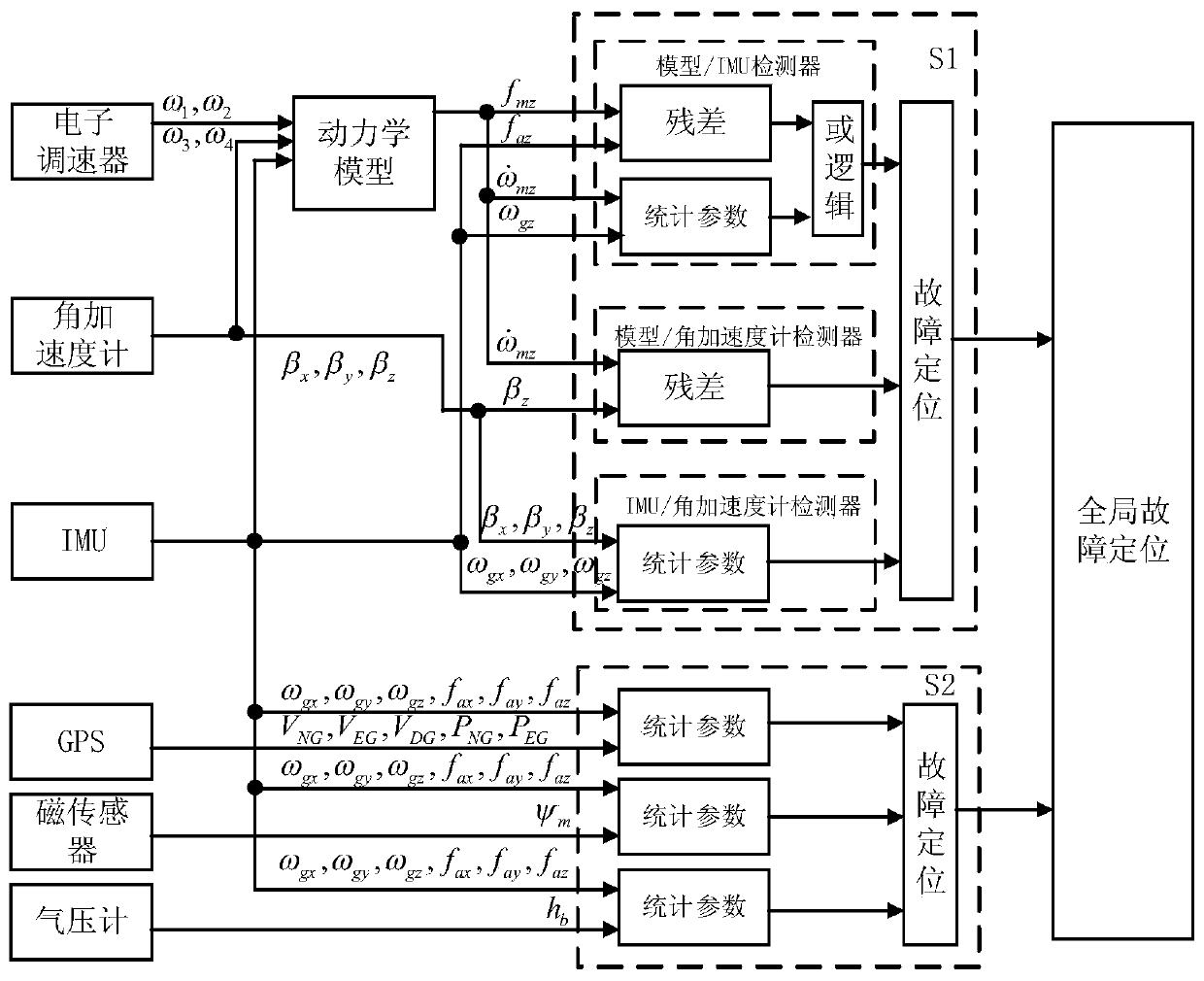
[0199] Step 2: Use the airborne sensor data output in Step 1, to construct an angular accelerometer / dynamic model / IMU fault detection filter S1 and IMU / magnetic sensor / GPS / barometer fault detection filter S2; S1 includes three The parallel sub-detectors are angular accelerometer / dynamic model sub-detector D1, angular accelerometer / IMU sub-detector D2 and dyn...


PUM


Abstract

The invention discloses an aircraft fault tolerant navigation estimation method of analytic redundancy. The method comprises the following steps: firstly estimating acceleration and angular acceleration information of the aircraft by utilizing a kinetic model of a rotor aircraft; secondly, constructing an angular accelerometer / kinetic model / IMU fault detection filter and an IMU / magnetic sensor / GPS / barometer fault detection filter; and then constructing a fault positioning strategy of two fault detection filters, thereby realizing the fault positioning on the navigation sensor; and finally, isolation the fault sensor according to the fault detection result, thereby accomplishing the navigation information resolving. By importing the kinetic model and the angular accelerometer, the fault detection on the angular accelerometer, the kinetic model, the IMU and the measurement sensor is realized, and the kinetic model can be used for completely replacing the fault IMU to perform navigation resolving, and the fault tolerance performance of the navigation system is improved.

Description

Technical field [0001] The invention belongs to the technical field of navigation, and particularly relates to an aircraft fault-tolerant navigation estimation method. Background technique [0002] The airborne navigation sensor is the data source for the aircraft to perform navigation calculation, and the navigation information calculated is the basis for the aircraft to perform stable flight. Currently commonly used airborne navigation sensors include inertial sensors-IMU and measurement sensors-magnetic sensors, GPS, barometers, etc. However, in some special environments, the performance of the airborne navigation sensor decreases or even fails. For example, sonic interference can destroy the performance of the IMU, and urban occlusion can cause GPS signal loss. If a faulty sensor is used to participate in the navigation solution, it will cause the aircraft to lose control or even crash. Summary of the invention [0003] In order to solve the technical problems mentioned in t...

Claims


Application Information

Patent Timeline
Patent Type & Authority Applications(China)
IPC IPC(8): G01C21/16G01C21/20G01C25/00G06F17/13
CPCG01C21/165G01C21/20G01C25/00G01C25/005G06F17/13
Inventor 吕品刘士超赖际舟李志敏王炳清
Owner NANJING UNIV OF AERONAUTICS & ASTRONAUTICS
Why Eureka
Try Eureka