Method for realizing meteor trail communication network simulation based on GIS system

A meteor trail communication and network simulation technology, applied in the field of communication, can solve the problems of unintuitive results, low reliability, and many manual operations, and achieve the effect of intuitive display, good human-machine interface, and strong operability.

Active Publication Date: 2019-11-08
NO 54 INST OF CHINA ELECTRONICS SCI & TECH GRP
View PDF3 Cites 2 Cited by
  • Summary
  • Abstract
  • Description
  • Claims
  • Application Information

AI Technical Summary

Problems solved by technology

[0003] Aiming at the defects in the prior art, the present invention can overcome the problems of many manual operations, low efficiency, low reliability, and unintuitive results in the existing network simulation, and proposes a method for realizing meteor trail communication network simulation based on the GIS system, Include the following steps:

Method used


Image

  • Method for realizing meteor trail communication network simulation based on GIS system
  • Method for realizing meteor trail communication network simulation based on GIS system
  • Method for realizing meteor trail communication network simulation based on GIS system

Examples


Embodiment Construction

[0026] The present invention will be described in further detail below in conjunction with the accompanying drawings and specific embodiments.

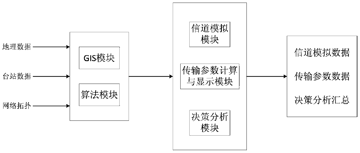
[0027] The invention provides a method for realizing meteor trail communication network simulation based on a GIS system, and realizes functions such as generation of meteor trail simulation channel data, calculation and display of transmission parameters, decision analysis and the like.

[0028] figure 1 It is a block diagram of the program module corresponding to the method steps of the present invention. In the implementation process, geographic data, station data, and network topology are data input, and the current meteor trail is built in the GIS platform through the calculation and processing of the GIS module and the algorithm module. Planning scheme of communication network. The channel simulation data is output through the channel simulation module, the transmission parameter data is output through the transmission paramete...


PUM


Abstract

The invention discloses a method for realizing meteoric trail communication network simulation based on a GIS (Geographic Information System) system, and belongs to the technical field of communication. In traditional meteoric trail communication network simulation, functions are only limited to prediction of network connectivity, and the method is provided for further providing systematic decision support. The method is composed of three main modules of channel simulation, transmission parameter calculation and decision analysis, on the basis of a meteor trail communication network planned ina GIS platform, the three modules are operated in sequence, channel simulation data, transmission parameter data and a decision report are output, operation is convenient, and the result is visual. Software simulation of a meteoric trail communication network is achieved. A good human-computer interface is achieved, the information transmission situation in the whole network can be efficiently and rapidly simulated, and a basis is provided for construction and use of the meteoric trail communication network.

Description

technical field [0001] The invention belongs to the technical field of communication, and relates to a meteor trail communication network simulation method based on a GIS (Geographic Information System) system, specifically, to realizing channel simulation, transmission parameter calculation and display, and decision analysis based on a GIS system. Background technique [0002] The meteor trail channel is based on the forward scattering of the radio waves by the ionized trail formed after the meteor shoots into the earth's high-altitude atmosphere and burns up. It has the characteristics of randomness, intermittent, and suddenness. Regionality, the communication efficiency of the meteor trail link is closely related to geographic information such as terrain and landform. The traditional meteor trail communication system simulation function is limited to predicting network connectivity, and cannot provide users with a series of systematic decision support. Contents of the i...

Claims


Application Information

Patent Timeline
IPC IPC(8): H04B17/00H04B17/391H04B7/22H04L12/24H04L12/26H04L12/727H04L45/121
CPCH04B17/0087H04B17/3912H04B7/22H04L41/145H04L41/12H04L45/121H04L43/0852H04L43/0876
Inventor 钟亚王旭宋晓倩肖永剑于晓磊宋建明
Owner NO 54 INST OF CHINA ELECTRONICS SCI & TECH GRP
Why Eureka
Try Eureka