High-precision real estate measurement method based on multi-rotor unmanned aerial vehicle

A multi-rotor unmanned aerial vehicle and multi-rotor unmanned technology, which is applied in the direction of motor vehicles, aircraft parts, aircraft, etc., can solve the problems of heavy workload, high labor intensity, long project cycle, etc. The effect of load and flight stability

Inactive Publication Date: 2019-11-22
CHINA JK INST OF ENG INVESTIGATION & DESIGN
View PDF3 Cites 10 Cited by
  • Summary
  • Abstract
  • Description
  • Claims
  • Application Information

AI Technical Summary

Problems solved by technology

Real estate survey is a kind of cadastral survey, which requires high precision. The traditional survey method is to use the combination of total station and RTK, which is labor-intensive and heavy workload. After a lot of testing and engineering verification, the project cycle is long and the efficiency is low.

Method used


Image

  • High-precision real estate measurement method based on multi-rotor unmanned aerial vehicle
  • High-precision real estate measurement method based on multi-rotor unmanned aerial vehicle
  • High-precision real estate measurement method based on multi-rotor unmanned aerial vehicle

Examples


Embodiment Construction

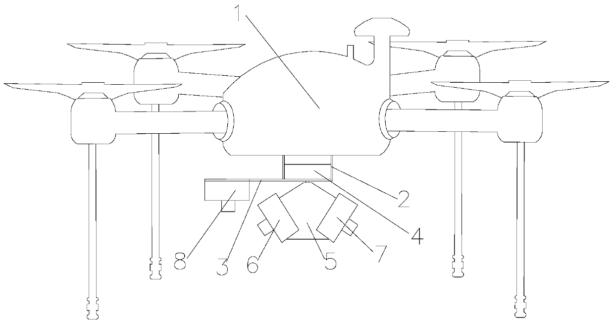
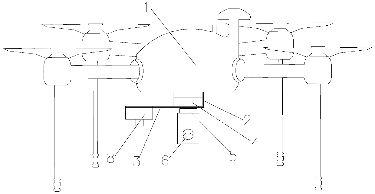
[0040] Such as Figure 1 to Figure 5 As shown, a kind of high-precision real estate measurement method based on multi-rotor UAV of the present invention comprises the following steps:

[0041] Step 1, build the multi-rotor UAV high-precision real estate measuring device: establish a ground station and a base station communicating with the multi-rotor UAV 1 on the ground, install an image acquisition mechanism at the bottom of the body of the multi-rotor UAV 1, the multi-rotor UAV 1 Rotor UAV 1, image acquisition mechanism, ground station and base station constitute a multi-rotor UAV high-precision real estate measurement device;

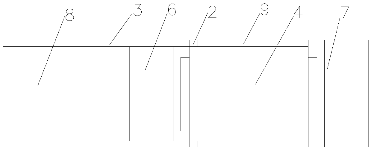
[0042] The image acquisition mechanism includes a plurality of vertical support rods 2 installed at the bottom of the body of the multi-rotor UAV 1, and one end of the plurality of vertical support rods 2 away from the bottom of the body of the multi-rotor UAV 1 is provided with a step for installation. Into the mounting plate 9 of the motor 4, the ...


PUM


Abstract

The invention discloses a high-precision real estate measurement method based on a multi-rotor unmanned aerial vehicle. The method comprises the following steps: 1, a multi-rotor unmanned aerial vehicle high-precision real estate measurement device is constructed; 2, photo control points are arranged and the geographic coordinates of the photo control points are obtained; 3, route planning is carried out; 4, data acquisition is carried out; 5, data processing is carried out; 6, a live three-dimensional model for a to-be-measured real estate measurement area is established; 7, mapping is carried out; and 8, precision check is carried out. The multi-rotor unmanned aerial vehicle is used to carry an oblique camera and a vertical camera to acquire high-definition three-dimensional image data,the live three-dimensional model is generated, naked-eye three-dimensional mapping is carried out in the live three-dimensional model, the real estate geographic information is rapidly obtained, the labor intensity and the workload of operators are greatly reduced, and the efficiency is high.

Description

technical field [0001] The invention belongs to the technical field of real estate measurement, and in particular relates to a high-precision real estate measurement method based on a multi-rotor drone. Background technique [0002] UAV aerial photogrammetry is a high-tech developed in recent years. It subverts the limitation that the previous orthophoto can only be taken from a vertical angle. Capture images from different angles, introducing users to a real and intuitive world that conforms to human vision. UAVs have the advantages of fast response, high processing efficiency, and low operating costs. The combination of the two has subverted the traditional surveying and mapping operation method, and the high-definition stereoscopic image data can be obtained through low-altitude multi-lens photography of UAVs, which can quickly realize geographic information. Acquisition has the characteristics of high efficiency, low cost, accurate data, flexible operation, rich side in...

Claims


Application Information

Patent Timeline
Patent Type & Authority Applications(China)
IPC IPC(8): G01C11/02B64C39/02B64D47/08
CPCB64C39/02B64D47/08G01C11/02
Inventor 杨永林杨超潘东峰赵国梁丁吉峰郑建国张继文夏玉云廖东军刘洋张腾飞王虎
Owner CHINA JK INST OF ENG INVESTIGATION & DESIGN
Why Eureka
Try Eureka