Terrain steep ridge line information fusion method for regular grid DEM construction

A fusion method and steep technology, applied in 3D modeling, climate sustainability, instruments, etc., can solve problems such as shape distortion, achieve the effect of maximizing utilization, simplifying the process, and improving shape effects

Active Publication Date: 2019-12-06
CHUZHOU UNIV
View PDF3 Cites 5 Cited by
  • Summary
  • Abstract
  • Description
  • Claims
  • Application Information

AI Technical Summary

Problems solved by technology

This method adopts two key technical links, the offset of the elevation node of the terrain steep line and the encrypted generation of virtual elevation sampl

Method used


Image

  • Terrain steep ridge line information fusion method for regular grid DEM construction
  • Terrain steep ridge line information fusion method for regular grid DEM construction
  • Terrain steep ridge line information fusion method for regular grid DEM construction

Examples


Embodiment

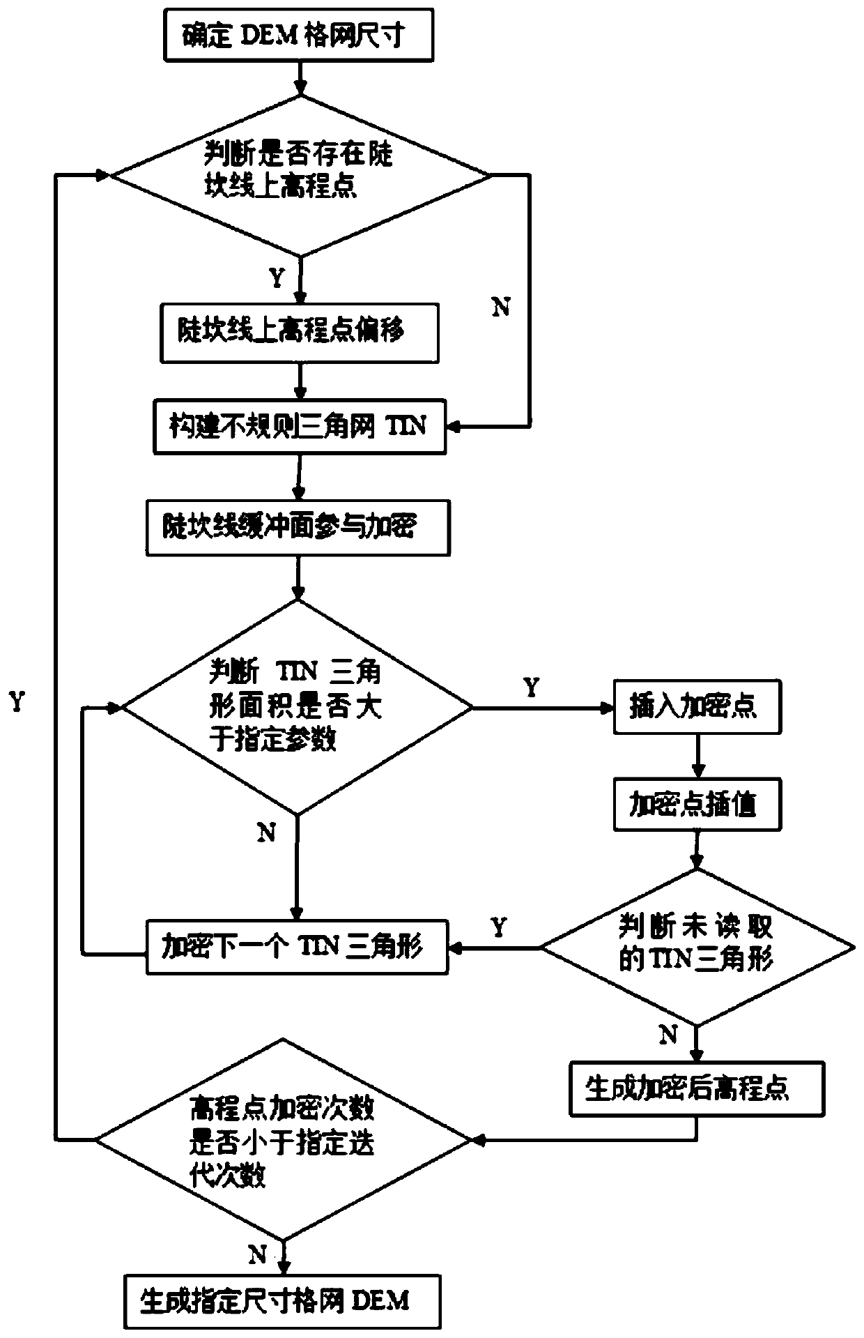
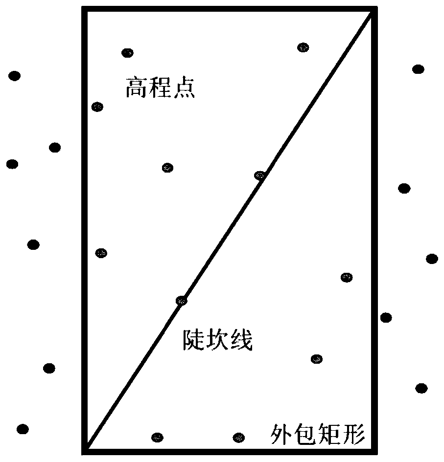
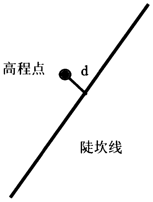
[0091] The existing classic DEM construction methods can better reflect the natural undulation characteristics of the surface, but for the surface with the interlaced distribution of gradual and abrupt terrain, and the mixed distribution of artificial terrain and natural terrain, the existing DEM terrain description and application have serious distortion phenomena. , with low morphological fidelity. In order to verify the practicability of the method of the present invention for the fidelity simulation of complex terrains such as abrupt terrains and urban terrains, an example was selected in Nanjing where there are many artificial terrain transformations, the terrain is flat and has obvious terrain features. This example focuses on a ground object For the sudden change in elevation near the feature line (slope line), the sub-encryption is used to compare the characteristics of the ground features and verify the accuracy. The implementation steps are as follows:

[0092] Step...


PUM


Abstract

The invention discloses a terrain steep ridge line information fusion method for regular grid DEM construction. The method comprises the following steps: S1, determining the minimum height differenceof regional steep ridge lines, and then determining the grid size of a target regular grid DEM; S2, deviating an elevation point on the steep ridge line, namely, deviating the elevation point fallingon the steep ridge line by a certain distance towards one side of the steep ridge line; S3, performing iterative encryption in a certain range of the steep ridge line to generate elevation points; andS4, constructing a regular grid DEM. According to the method, two key technical links of terrain steep ridge line elevation node offset and encryption generation considering virtual elevation sampling points around the steep ridge line are adopted, and the problem of form distortion caused by the terrain steep ridge line in high-precision terrain modeling can be effectively solved.

Description

technical field [0001] The invention belongs to the technical field of high-precision digital elevation model construction, and relates to a method for effectively integrating terrain steep slope lines in the process of constructing a regular grid DEM to improve the elevation accuracy and shape accuracy of the DEM construction. Background technique [0002] Digital Elevation Model (DEM for short) is the core content of national basic geographic data. At present, my country has initially completed the construction of 1:1 million, 1:250,000, 1:50,000 and 1:10,000 DEM data in some areas. These data play an indispensable and important role in the national economy, national defense construction and scientific research. Its application fields cover many fields such as surveying and mapping, transportation, military, water conservancy, agriculture, environment, resource management, planning and tourism. [0003] The existing classic DEM construction methods can better reflect the ...

Claims


Application Information

Patent Timeline
IPC IPC(8): G06T17/05G06T17/20
CPCG06T17/05G06T17/20Y02A90/10
Inventor 赵明伟江岭王春杨灿灿居肖肖徐燕
Owner CHUZHOU UNIV
Why Eureka
Try Eureka