Farmland operating area measuring and calculating method based on GPS positioning data of agricultural machinery

A GPS positioning and GPS positioning point technology, applied in the field of agricultural machinery data analysis, can solve problems such as low efficiency, heavy farming, and difficulty in determining the location of overlapping parts, and achieve the effect of high efficiency and less time.

Active Publication Date: 2020-01-14
潍坊中科晶上智能装备研究院有限公司
View PDF5 Cites 6 Cited by
  • Summary
  • Abstract
  • Description
  • Claims
  • Application Information

AI Technical Summary

Problems solved by technology

[0004] The method of using manpower to measure and rely on manual hand-held operating area measurement equipment to measure is not only inefficient but also increases unnecessary labor costs; according to the method of measuring the path of agricultural machinery, the length of the path traveled by the agricultural machinery is multiplied by the width of the farm tool To calculate the operating area, this method has the problem of heavy plowing, and the calculated operating area is larger than the actual operating area.
[0005] The polygonal area boundary modeling method collects n vertices of the polygonal farmland operation area boundary, establishes the upper boundary function model and the lower boundary function model to complete the boundary modeling, and then calculates the area between the upper and lower boundary functions. The accuracy requirement is high, the positioning of the boundary vertices is not accurate, and the result of the operation area measurement is also inaccurate. At the same time, this meth

Method used


Image

  • Farmland operating area measuring and calculating method based on GPS positioning data of agricultural machinery
  • Farmland operating area measuring and calculating method based on GPS positioning data of agricultural machinery
  • Farmland operating area measuring and calculating method based on GPS positioning data of agricultural machinery

Examples


Embodiment Construction

[0036] The present invention will be described in detail below with reference to the accompanying drawings and examples.

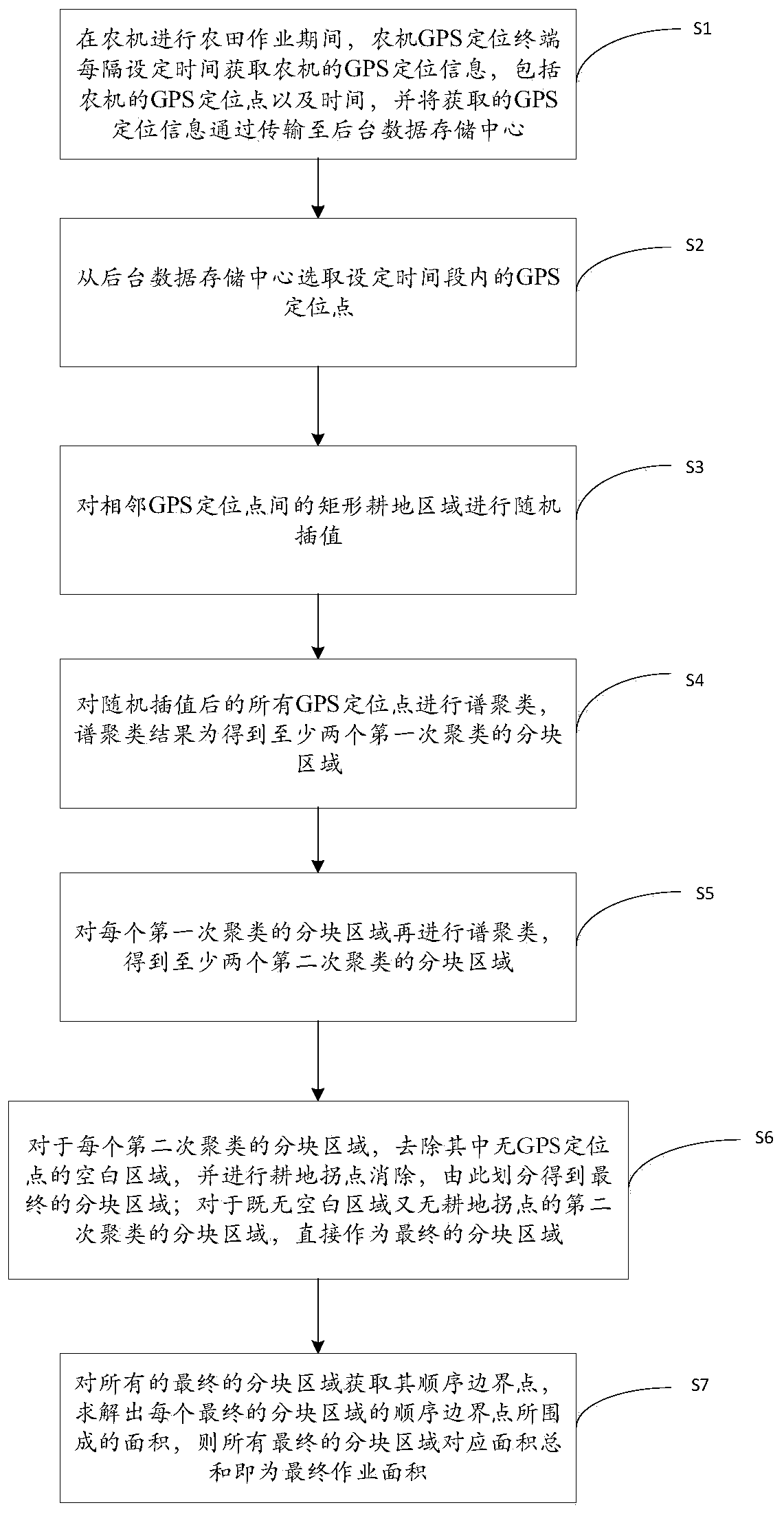
[0037] The invention provides a method for measuring and calculating the farmland operation area based on the GPS positioning data of agricultural machinery, such as figure 1 shown, including the following steps:

[0038] S1. During the farmland operation of the agricultural machinery, the GPS positioning terminal of the agricultural machinery obtains the GPS positioning information of the agricultural machinery every set time, including the GPS positioning point and time of the agricultural machinery, and transmits the obtained GPS positioning information to the background data storage center. Specifically, GPS positioning information can be transmitted to the background data storage center in a wireless manner

[0039] After the farmland operation is completed, go to S2.

[0040] S2. Select the GPS positioning points within the set time period from the...


PUM


Abstract

The invention discloses a farmland operating area measuring and calculating method based on GPS positioning data of agricultural machinery. Effective and accurate area measurement can be performed onthe farmland operating area, and a re-farming removal effect is achieved. The method comprises the following steps: during farmland operation, obtaining, by a GPS positioning terminal of the agricultural machinery, GPS positioning information of the agricultural machinery after every set time, transmitting the GPS positioning information to a background data storage center, after the farmland operation is completed, selecting GPS positioning points within the set time period, performing random interpolation on a rectangular cultivated land area between the adjacent GPS positioning points, andperforming spectral clustering on all GPS positioning points after the random interpolation to obtain at least two block regions of first time clustering; performing spectral clustering on each blockregion of first time clustering to obtain at least two block regions of second time clustering; for each block region of second time clustering, removing a blank region without the GPS positioning point, and removing cultivated land inflection points to obtain final block regions; and using the total sum of areas corresponding to all final block regions as a final operating area.

Description

technical field [0001] The invention relates to the technical field of agricultural machinery data analysis, in particular to a method for measuring and calculating farmland operation area based on agricultural machinery GPS positioning data. Background technique [0002] As rural land becomes more and more concentrated, large farmland provides favorable conditions for mechanized farming. Mechanized and intelligent modern agriculture is constantly developing. Under the development trend of precision agriculture, the measurement of agricultural machinery operation area can count crops on the one hand. Yield, on the other hand, is also the basis for charging for public agricultural machinery operations, so efficient and accurate methods for calculating the operating area are urgently needed. [0003] The existing methods for measuring and calculating the working area of ​​agricultural machinery mainly have the problem of not being able to effectively solve the problem of calcu...

Claims


Application Information

Patent Timeline
IPC IPC(8): G01B7/32G01B7/004G01S19/14
CPCG01B7/004G01B7/32G01S19/14
Inventor 邱大伟谭雯雯刘子辰张玉成石晶林
Owner 潍坊中科晶上智能装备研究院有限公司
Why Eureka
Try Eureka