High-precision positioning system and positioning method based on vehicle-road coordination

A vehicle-road coordination and positioning method technology, which is applied in satellite radio beacon positioning systems, radio wave measurement systems, road network navigators, etc., can solve the problems of inaccurate positioning, high equipment and engineering costs, and achieve improved utilization, High-precision positioning, the effect of reducing repetitive investment

Active Publication Date: 2021-05-25
成都云科新能汽车技术有限公司
View PDF0 Cites 0 Cited by
  • Summary
  • Abstract
  • Description
  • Claims
  • Application Information

AI Technical Summary

Problems solved by technology

[0006] The purpose of the present invention is to provide a high-precision positioning system and positioning method based on vehicle-road coordination, which is used to solve the technical problems in the prior art. positioning, and if the UWB base station is deployed in a large area outdoors, it will lead to higher equipment and engineering costs

Method used


Image

  • High-precision positioning system and positioning method based on vehicle-road coordination
  • High-precision positioning system and positioning method based on vehicle-road coordination
  • High-precision positioning system and positioning method based on vehicle-road coordination

Examples


Embodiment 1

[0068]Based on the high-precision positioning method of the car road, the specific content is as follows.

[0069]The first case: When the vehicle is within the coverage of the UWB base station of the first node of the field portion, the vehicle is decounted by the UWB module of the vehicle positioning terminal, and the position information output by the IMU module is fused. Get high-precision positioning information of the vehicle;

[0070]In the second case: When the vehicle has exports the UWB base station coverage of the first node, and has entered the monitoring range of the network camera of the corresponding section, the area management unit to which the above-described first node will be collected according to the real time collected by the webcam. The video data, the target vehicle is identified, tracks, and positions, and the result is sent by remote wireless communication; the vehicle receives positioning information from the field portion through the vehicle positioning termin...

Embodiment 2

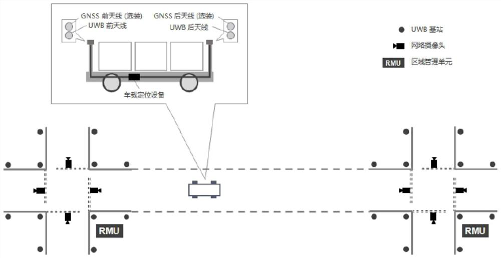
[0098]The high-precision positioning system based on the trail collaboration, mainly including two parts of the vehicle and the field. Among them, the vehicle is passed by the vehicle positioning terminal (including the core module, Options such as UWB, IMU, wireless communication, calculation and processing, optional RTK module), UWB antenna (front and back, one pair) and GNSS antenna (front and back, one pair, optional) )composition. The field part is composed of several regional grade subsystems (usually deployed in each key node of the park network), each of which includes a regional management unit (RMU), several UWB positioning base stations and webcams.

[0099]infigure 1 In the positioning system shown, the functions of the respective core components of the ends and field ends are as follows:

[0100]Car part

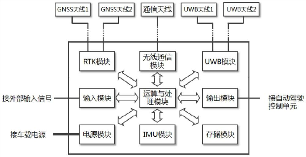
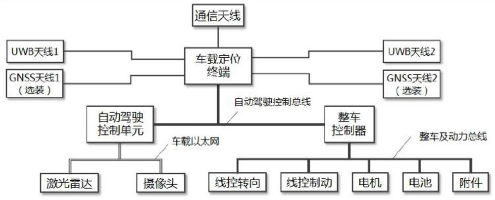
[0101]1) Vehicle positioning terminal

[0102]The on-board positioning terminal includes at least one UWB module, an IMU module, a wireless communication module, and an operation...


PUM


Abstract

The invention discloses a high-precision positioning system based on vehicle-road coordination, and a vehicle-mounted positioning terminal. The vehicle-mounted positioning terminal includes a UWB module, an IMU module, a wireless communication module, and an operation and processing module. The vehicle-mounted positioning terminal is used to process information from the UWB module. , The local signal output by the IMU module, and the remote signal received from the field end, and the corresponding position calculation, fusion and output. In the present invention, the minimum vehicle-end system only includes core modules such as UWB, IMU, wireless communication, computing and processing, and the cost is much lower than that of a high-precision positioning system using laser or visual SLAM.

Description

Technical field[0001]The present invention belongs to the field of intelligent network automotive technology, and specific to high-precision positioning systems and positioning methods based on road synergies.Background technique[0002]The airport, logistics park, and the manufacturer of specific scenes such as the factory are unmanned in recent years, driving and related technologies are most likely to achieve the direction of industrialization. The business process involved in the above scenarios often requires the carrier vehicle to be automatically driving in the indoor and outdoor correlation regions, and this is also correspondingly requested by the positioning technology of the vehicle.[0003]High-precision positioning techniques for the above automatic driving application scenarios are usually divided into two categories, and one is to achieve the position of the vehicle in outdoor and indoor by differential GPS (or other GNSS systems) and UWB, and the other is based on laser ...

Claims


Application Information

Patent Timeline
Patent Type & Authority Patents(China)
IPC IPC(8): G01C21/34G01S19/48
CPCG01C21/3415G01S19/48
Inventor 曾帆刘力杨旭姚远康权
Owner 成都云科新能汽车技术有限公司
Why Eureka
Try Eureka