System and method for simulating imaging of sea surface and ship composite scene by stationary orbit SAR
A geostationary orbit and scene imaging technology, applied in radio wave measurement systems, radio wave reflection/re-radiation, utilization of re-radiation, etc. question
- Summary
- Abstract
- Description
- Claims
- Application Information
AI Technical Summary
Problems solved by technology
Method used
Image
Examples
Embodiment Construction
[0069] Below in conjunction with accompanying drawing and specific embodiment the present invention is described in further detail:
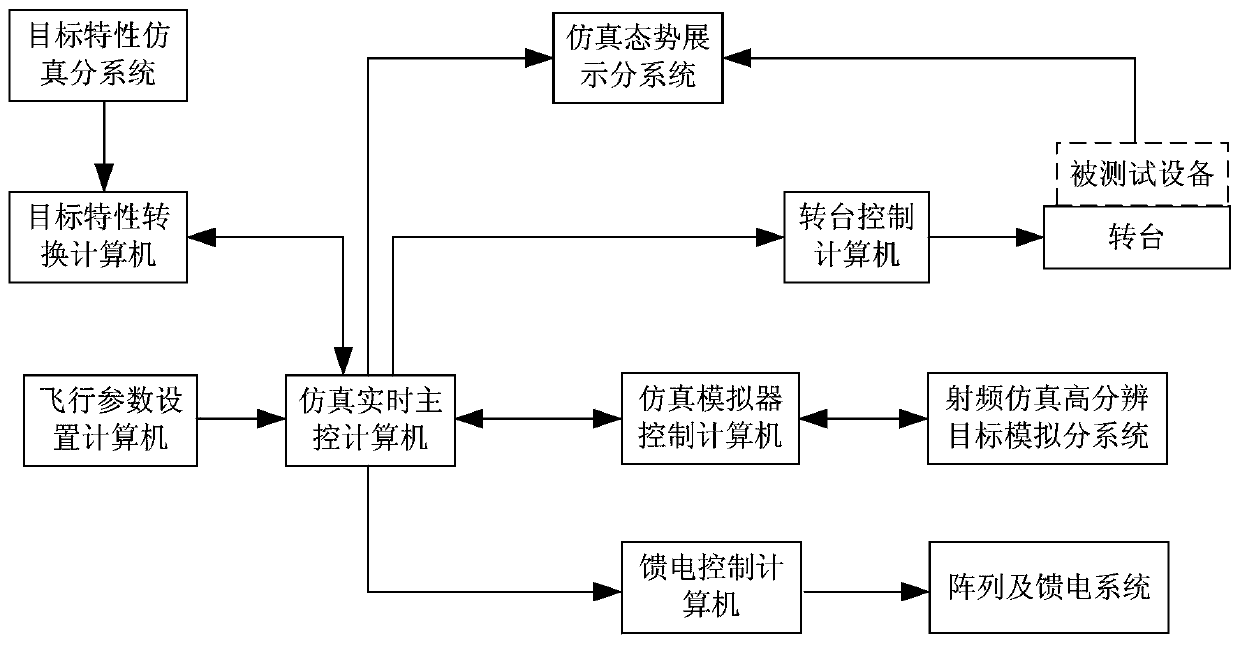
[0070] The present invention provides a static orbit SAR imaging simulation system and method for the composite scene of the sea surface and ships, which simulates the motion trajectory, motion attitude, motion sea surface and ship composite scene of the static orbit SAR, and images the composite scene of the motion sea surface and the ship with the static orbit SAR. The process is accurately simulated to verify the imaging algorithm of geostationary orbit SAR for moving sea surfaces and composite scenes of ships. Such as figure 1 Shown is a block diagram of a high-fidelity hardware-in-the-loop simulation system for moving sea surface and ship composite scene imaging by geostationary orbit SAR of the present invention, which is realized through the following steps:
[0071] 1. A geostationary orbit SAR imaging simulation system and method for t...
PUM
 Abstract
Description
Claims
Application Information
 - R&D
- Intellectual Property
- Life Sciences
- Materials
- Tech Scout
- Unparalleled Data Quality
- Higher Quality Content
- 60% Fewer Hallucinations
Browse by: Latest US Patents, China's latest patents, Technical Efficacy Thesaurus, Application Domain, Technology Topic, Popular Technical Reports.
© 2025 PatSnap. All rights reserved.Legal|Privacy policy|Modern Slavery Act Transparency Statement|Sitemap|About US| Contact US: help@patsnap.com


