A composite scene imaging simulation system and method of sea surface and ship by geostationary orbit SAR

A geostationary orbit and scene imaging technology, which is applied to radio wave measurement systems, instruments, and measurement devices, can solve problems such as difficult acquisition of geostationary orbit SAR measured data, motion compensation algorithms that cannot be effectively verified, etc.

Active Publication Date: 2021-09-07
BEIJING RES INST OF TELEMETRY +1
View PDF19 Cites 0 Cited by
  • Summary
  • Abstract
  • Description
  • Claims
  • Application Information

AI Technical Summary

Problems solved by technology

Under the existing conditions, it is difficult to realize the acquisition of geostationary orbit SAR measured data, so the geostationary orbit SAR imaging algorithm and motion compensation algorithm cannot be effectively verified

Method used


Image

  • A composite scene imaging simulation system and method of sea surface and ship by geostationary orbit SAR
  • A composite scene imaging simulation system and method of sea surface and ship by geostationary orbit SAR
  • A composite scene imaging simulation system and method of sea surface and ship by geostationary orbit SAR

Examples


Embodiment Construction

[0069] The present invention will be further described in conjunction with the accompanying drawings and specific examples:

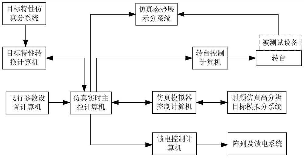
[0070] The present invention provides a geostationary orbit SAR scene simulation system and method for imaging a vessel and sea composite simulated SAR geostationary orbit trajectory, the motion and the attitude and sea vessels composite motion scenes, the motion of the sea on the geostationary orbit and the SAR scene imaged composite vessel process for accurate simulation to verify the movement of the sea geostationary orbit SAR vessels and composite scene imaging algorithm. like figure 1 Loop simulation system block diagram of a high fidelity image of the scene motion and sea vessels complex SAR GSO present invention is shown, which is achieved by the steps of:

[0071] 1, a static orbit SAR scene simulation system and method for forming a composite and sea vessels, characterized by: a real-time simulation of the host computer, for exchanging data and tim...


PUM


Abstract

The present invention is a static orbit SAR imaging simulation system and method for sea surface and ship composite scene, the target characteristic simulation subsystem generates the moving sea surface and ship composite scene, and the flight parameter setting computer generates the flight attitude and flight track of the tested static orbit SAR device , to control the attitude of the tested geostationary orbit SAR device; generate the one-dimensional range image data corresponding to the current position angle of the geostationary orbit SAR in the moving sea surface and the compound scene of the ship, and convert it into the corresponding geostationary orbit SAR echo signal, and pass the feed The control computer is radiated to the tested geostationary orbit SAR device by the array and the feed system, and finally the tested geostationary orbit SAR device performs imaging processing on the received echo signal and displays it on the simulation situation display subsystem.

Description

Technical field [0001] The present invention relates to a stationary orbit SAR on sea surface and vessel composite scene imaging simulation system and method belonging to SAR semi-real simulation technology. Background technique [0002] Still Track SAR is a active remote sensing radar that places SAR payload in the earth synchronous track satellite. Its main advantage is that the surface coverage is wide, strong anti-strike capacity, and the repeated access cycle is short, it is the future SAR SAR research and The important direction of development. However, the motion characteristics and Doppler characteristics of the still track SAR are different from other low-track and mid-track SAR, with long synthetic aperture time and bending trajectory, their motion characteristics and Doppler are subsequent track SAR The foundation of the study method research. Under the existing conditions, it is difficult to achieve an admission of the still track SAR measured data, so the still track...

Claims


Application Information

Patent Timeline
Patent Type & Authority Patents(China)
IPC IPC(8): G01S7/40G01S13/90
CPCG01S7/4052G01S13/90G01S7/4082
Inventor 宫兰晖谢筱张振华肖忠源
Owner BEIJING RES INST OF TELEMETRY
Why Eureka
Try Eureka