
Aerospace emission light, thunder, remote and navigation satellite measurement data fusion processing method

A technology for navigation satellites and space launch, applied in the field of space launch

Active Publication Date: 2020-04-17
中国人民解放军63620部队
View PDF19 Cites 6 Cited by
  • Summary
  • Abstract
  • Description
  • Claims
  • Application Information

AI Technical Summary

Problems solved by technology

At present, there is no report on the real-time fusion of the measurement elements of the external measurement system, the apparent velocity increment of the launch vehicle navigation calculation trajectory, and the measurement results of the launch vehicle navigation satellite.

Method used


Image

  • Aerospace emission light, thunder, remote and navigation satellite measurement data fusion processing method
  • Aerospace emission light, thunder, remote and navigation satellite measurement data fusion processing method
  • Aerospace emission light, thunder, remote and navigation satellite measurement data fusion processing method

Examples


Embodiment Construction

[0069] The navigation computer of the launch vehicle obtains the ballistic parameters of the launch inertial coordinate system by processing the output pulse numbers of the high-precision accelerometer, the output pulse numbers of the high-precision gyroscope and the high-precision earth gravity model, and the ballistic parameters of the launch inertial coordinate system are sent to sent outside. The telemetry data received on the ground includes the ballistic data of the launch inertial coordinate system, and these data are decoded and restored by the ground telemetry data processing system to become the telemetry ballistic data.

[0070] The main symbols to be used in the present invention are defined as follows:

[0071] x l — launch vehicle telemetry ballistic parameters;

[0072] X—the ballistic parameter of the launching coordinate system of the launch vehicle;

[0073] x m — launch vehicle measurement coordinate system ballistic parameters;

[0074] x s — Ballisti...


PUM


Abstract

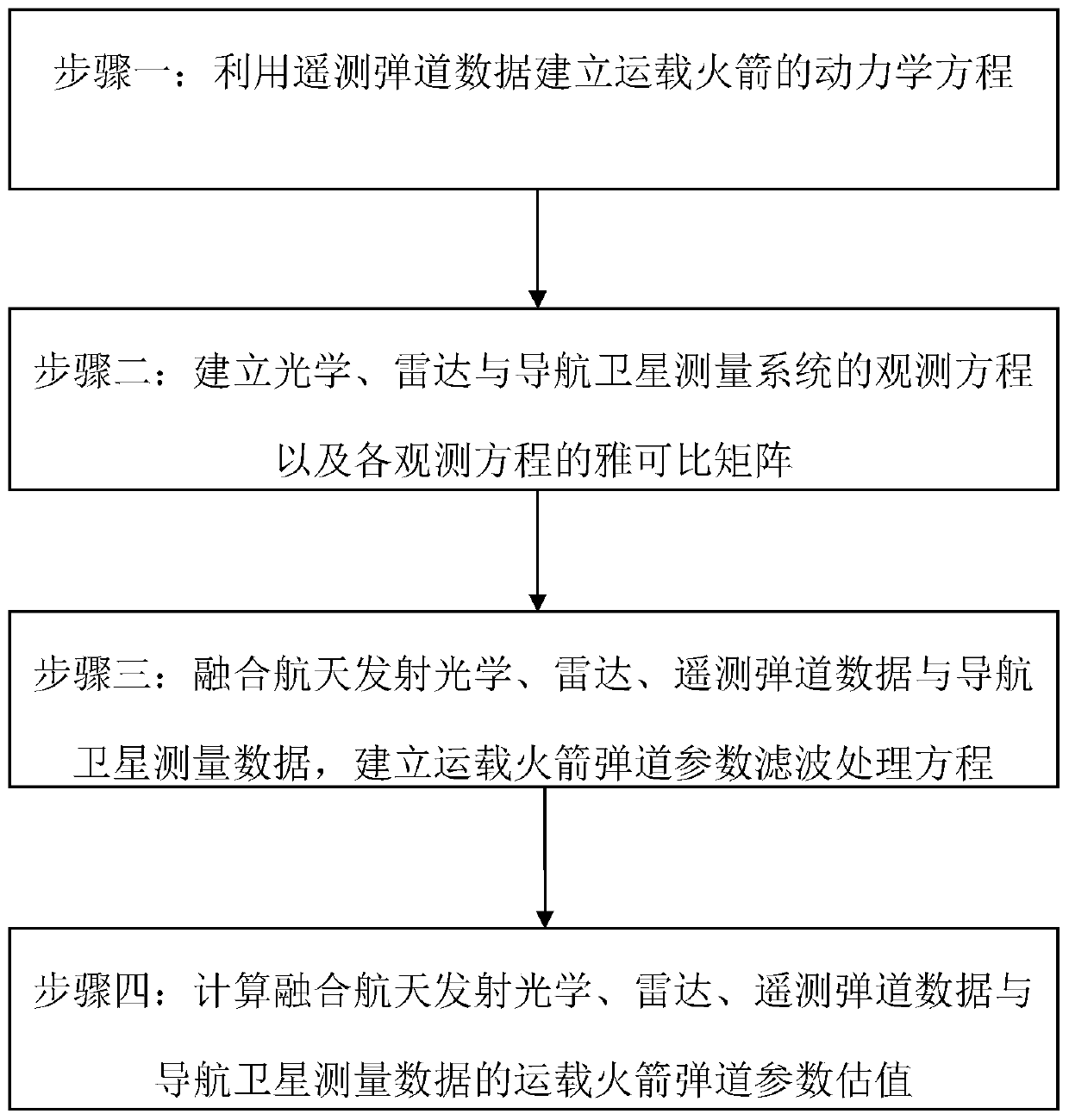
The invention belongs to the field of spaceflight launching and the field of spaceflight measurement and control, and discloses an aerospace emission light, thunder, remote and navigation satellite measurement data fusion processing method. The method includes: firstly, establishing a kinetic equation of a carrier rocket by utilizing telemetry trajectory data; secondly, establishing observation equations of an optical, radar and navigation satellite measurement system and a jacobian matrix of each observation equation; secondly, fusing spaceflight launching optics, radar, telemetry trajectorydata and navigation satellite measurement data, and establishing a carrier rocket trajectory parameter filtering processing equation; and finally, calculating a carrier rocket trajectory parameter estimation value fusing spaceflight launching optics, radar, telemetry trajectory data and navigation satellite measurement data. According to the invention, the advantages of various trajectory data arefully utilized, and the technical problem of lack of real-time deep fusion processing of spaceflight emission optics, radar, telemetry trajectory data and navigation satellite measurement data is solved.

Description

technical field [0001] The invention belongs to the field of aerospace launch and aerospace measurement and control, and relates to a data fusion processing method, in particular to optical measurement data, radar measurement data, carrier rocket navigation calculation data received by telemetry and carrier rocket navigation satellite measurement in the process of aerospace launch Real-time fusion processing method of various types of measurement data such as data. Background technique [0002] Among the real-time measurement data of space launch, there are three types of data related to flight trajectory: one is various external ballistic measurement data, that is, the measurement data of the optical and radar measurement systems at the launch site; The ballistic data calculated by the navigation computer downloaded by the telemetry system; the third is the navigation satellite measurement data downloaded by the launch vehicle through the telemetry system. The accuracy of ...

Claims


Application Information

Patent Timeline
IPC IPC(8): G06F30/20G06F17/16G06F17/13G01S19/37G01S7/41
CPCG06F17/16G06F17/13G01S19/37G01S7/418Y02T90/00
Inventor 陈德明张华马丽王婷婷
Owner 中国人民解放军63620部队
Learn More