Urban land utilization simulation cellular automaton method based on space errors

A cellular automaton and spatial error technology, applied in data processing applications, computer components, character and pattern recognition, etc., can solve the problem of inability to explain multicollinearity, autocorrelation effects, spatial heterogeneity, and increased computing costs problems, to achieve the effect of accurate conversion rules and high precision of simulation results

Active Publication Date: 2020-04-28
TONGJI UNIV
View PDF7 Cites 11 Cited by
  • Summary
  • Abstract
  • Description
  • Claims
  • Application Information

AI Technical Summary

Problems solved by technology

However, heuristic methods usually only provide local optimal solutions at a reasonable computational cost, and changes in the search range may lead to different results and a sharp increase in computational cost
[0003] There are both spatial heterogeneity and spatial dependence in the process of urban land use, and the complex geographical process brings great challenges to model construction
Logistic regression models (logit) can only provide global best-fit relationships and thus cannot account for multicollinearity, autocorrelation effects, and spatial heterogeneity in complex geographic processes

Method used


Image

  • Urban land utilization simulation cellular automaton method based on space errors
  • Urban land utilization simulation cellular automaton method based on space errors
  • Urban land utilization simulation cellular automaton method based on space errors

Examples


specific Embodiment

[0104] The actual concrete embodiment of the present invention is as follows:

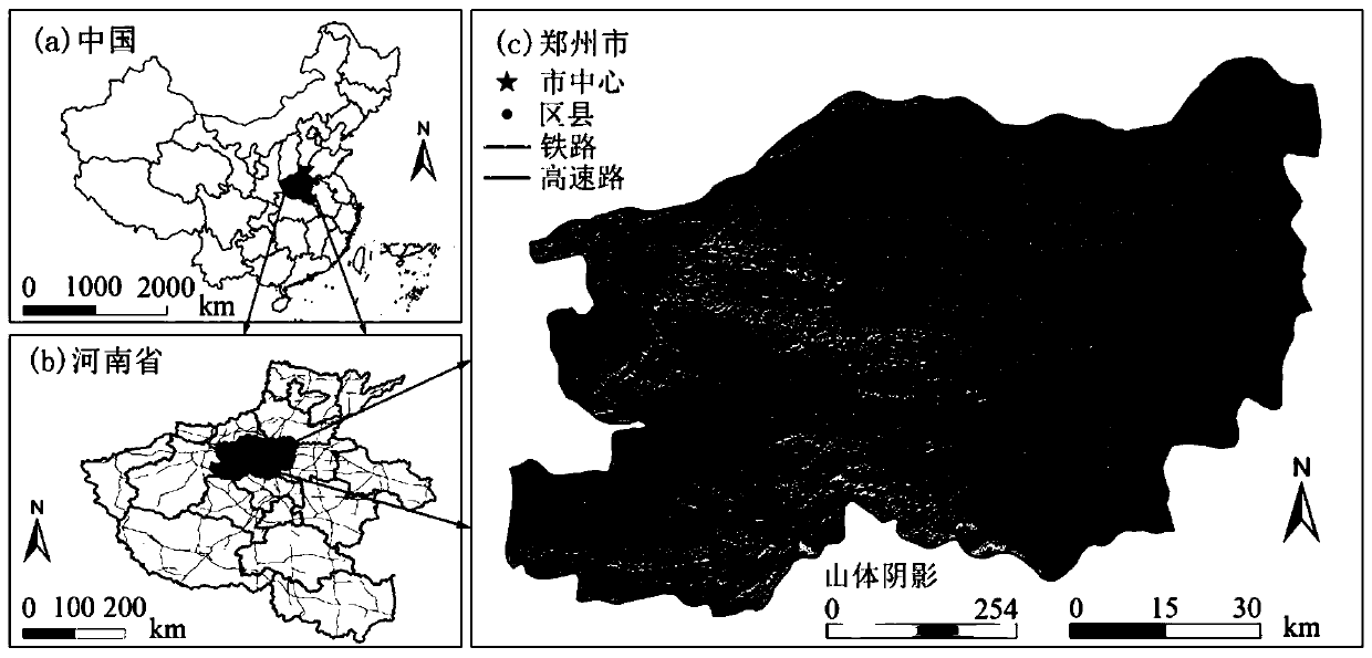
[0105] 1) The location of this case is as follows figure 2 shown. The land use data of Zhengzhou in 2000 and 2010 were extracted by GlobeLand30, and the urban land use pattern of Zhengzhou in 2000 and 2010 was obtained by reclassification. The support vector machine method interpreted the remote sensing image of Zhengzhou City acquired by Landsat8 / OLI on December 24, 2017, and obtained the urban land use pattern in 2017;

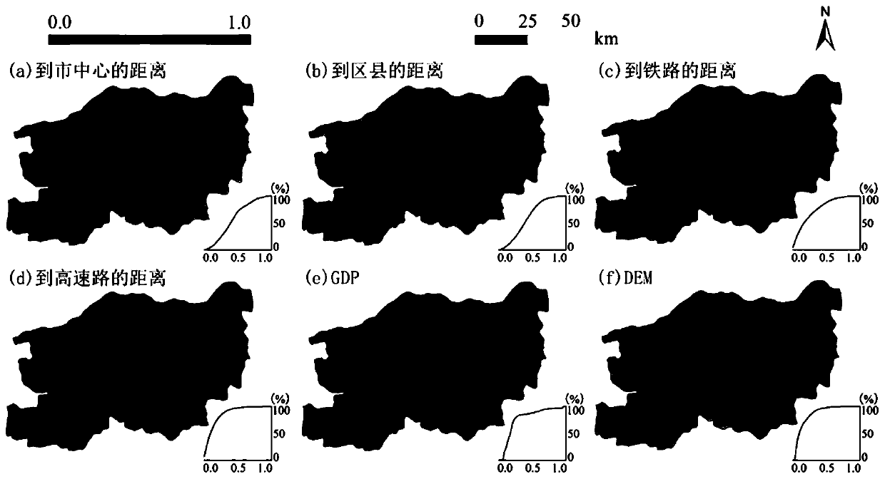
[0106] 3) Obtain the city location and traffic road network data, and get the distance to the city center, to the district and county center, to the railway, and to the expressway based on the Euclidean distance. After these distances are normalized, they are used as urban land use changes influencing factors. Obtain digital elevation model (DEM) and economic (GDP) data as topographic and socioeconomic influencers of land use change such as image 3 shown;

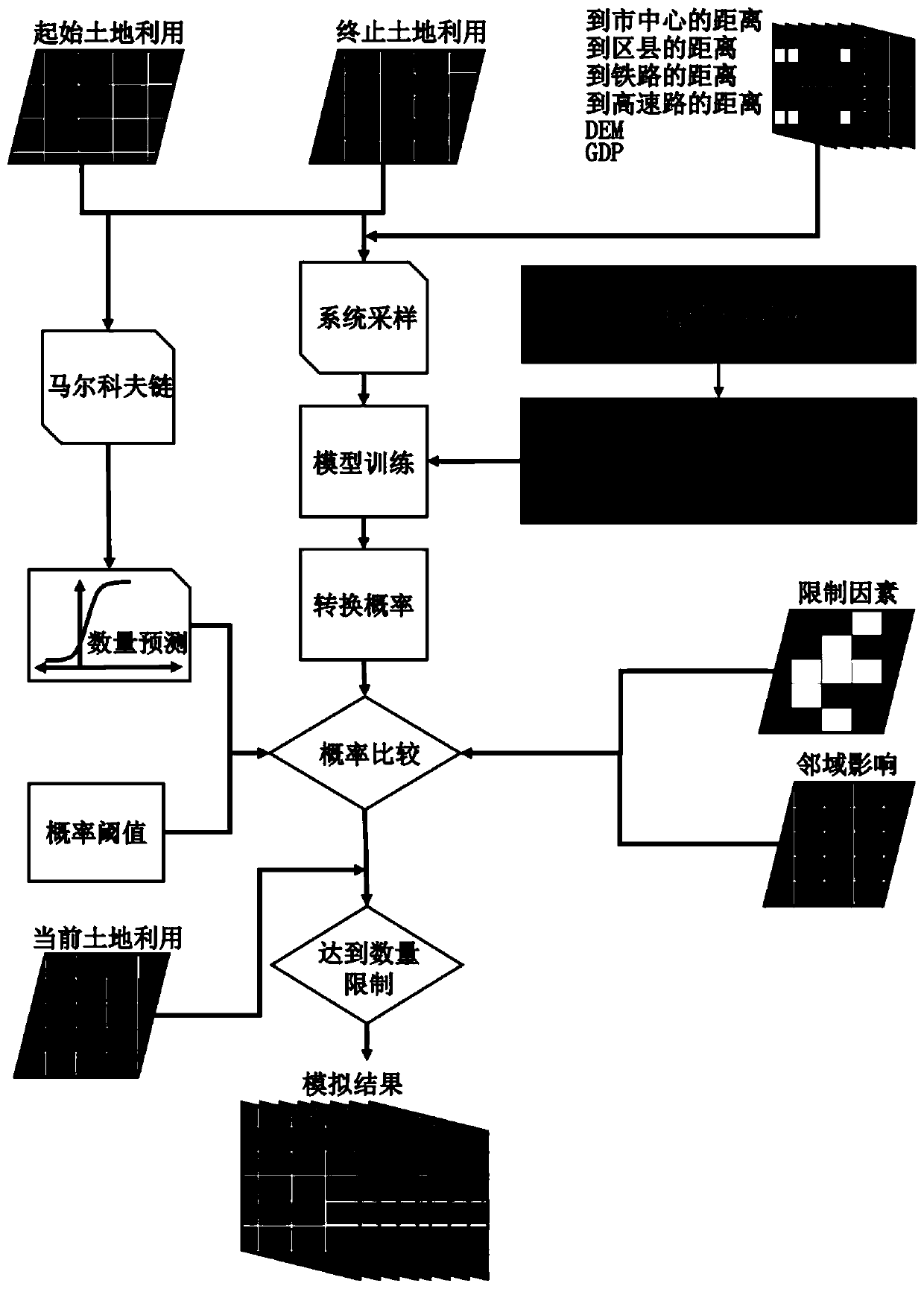
[0107] 4) Carry o...


PUM


Abstract

The invention relates to an urban land utilization simulation cellular automaton method based on space errors, which comprises: 1) classifying remote sensing images to obtain an urban land utilizationgraph and a driving factor; 2) performing system sampling on the urban land utilization map and the driving factor to obtain sample data; 3) training the sampling data by using SEM, and establishinga CA conversion rule; 4) evaluating the fitting performance of the conversion rule by adopting the log likelihood value and the AIC, and checking the effect; 5) establishing a CASEM new model, and calculating to generate an urban land transition probability graph; 6) predicting the number of urban cells at each time point in the future based on historical land utilization data of remote sensing classification; 7) using CASEM to simulate and predict an urban spatial pattern and an expansion process; and 8) performing, outputting and saving comprehensive evaluation of the simulation results using multiple types of indicators. Compared with the prior art, the urban land use simulation cellular automaton method based on the space error has the advantages that the space autocorrelation in the model error can be eliminated, and the simulation precision is improved.

Description

technical field [0001] The invention relates to an urban land use simulation method, in particular to a spatial error-based urban land use simulation cellular automata method. Background technique [0002] A cellular automaton (CA) model consists of spaces, discrete finite state elements, neighborhoods, and transition rules. The CA model uses local interactions to simulate the evolution of complex systems, which is highly consistent with the complexity of urban land use. In the past two decades, most works have adopted classical statistical methods, artificial neural networks, and meta-heuristic algorithms to obtain transformation rules. There is not only multicollinearity but also spatial autocorrelation among spatial drivers, which makes these methods not fully quantify the impact of spatial drivers on urban land use change. The parameters of the fuzzy logic method are subjective, while the parameters obtained by the artificial intelligence method often lack physical mea...

Claims


Application Information

Patent Timeline
Patent Type & Authority Applications(China)
IPC IPC(8): G06Q10/06G06Q50/26G06K9/62G06F30/20G06F119/14
CPCG06Q10/06393G06Q50/26G06F18/2411
Inventor 冯永玖童小华刘颂谢欢柳思聪
Owner TONGJI UNIV
Why Eureka
Try Eureka