Automatic positioning and orientating system for excavation and tunneling of tunnel, subway and mine

A technology of autonomous positioning and orientation system, applied in the field of autonomous positioning and navigation, it can solve the problems of deteriorating azimuth measurement accuracy, unable to support unmanned operation, and measurement error divergence with time, so as to achieve simple and rapid measurement of true north position and realize real-time measurement. and monitoring effects

Inactive Publication Date: 2020-05-08
TIANJIN NAVIGATION INSTR RES INST
View PDF19 Cites 4 Cited by
  • Summary
  • Abstract
  • Description
  • Claims
  • Application Information

AI Technical Summary

Problems solved by technology

[0002] In the process of unmanned excavation operations such as tunnels, subways and mines, it is necessary to know the precise position and orientation information of the car body in order to plan its working path or remotely control its implementation. When parking, the azimuth is in a random state and cannot support unmanned operations. In order to obtain its accurate azimuth value, it is necessary to use inertial navigation equipment and gyro theodolite for measurement
The azimuth information provided by the inertial navigation equipment, on the one hand, contains an initial error, and the current technical level can control the initial azimuth error within 3′; on the other hand, the measurement error of the inertial navigation diverges with time, which further deteriorates the azimuth measurement accuracy
The gyroscopic theodolite can provide high-precision azimuth information, but it needs to be specially erected, and the azimuth reference mirror of the collimated vehicle body requires frequent intervention by operators, which cannot realize unmanned mining in the true sense

Method used


Image

  • Automatic positioning and orientating system for excavation and tunneling of tunnel, subway and mine
  • Automatic positioning and orientating system for excavation and tunneling of tunnel, subway and mine
  • Automatic positioning and orientating system for excavation and tunneling of tunnel, subway and mine

Examples


Embodiment Construction

[0023] The present invention will be described in further detail below through specific examples. The following examples are only descriptive, not restrictive, and cannot limit the protection scope of the present invention.

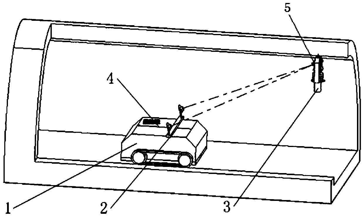
[0024] like figure 1 As shown, an autonomous positioning and orientation system for tunnel, subway and mine excavation includes a gyro total station 3, a dual-target component 2, a control point identification 5 and a wireless communication network. The gyro total station consists of a gyro device and a total station The instrument is composed of the AGT-5 gyro device and the total station instrument group produced by the 707 Research Institute of China Shipbuilding Industry Corporation. It has the functions of autonomous north-finding, ranging, searching for targets, and calculating three-dimensional coordinates. The gyro total station is hung on the top of the roadway, which is firm and stable, and it is several meters to hundreds of meters away from t...


PUM


Abstract

The invention relates to an automatic positioning and orientating system for excavation and tunneling of tunnels, subways and mines. The system comprises a gyro total station, a double-target assembly, a control point identifier and a wireless communication network. The gyro total station is composed of a gyro device and a total station body and has the functions of automatic north seeking, distance measuring, target searching and three-dimensional coordinate resolving, and the double-target assembly is fixedly connected to a heading machine body and is determined and stable with the central position of the heading machine body and the angle relation of bow and stern lines. The control point identifier is arranged on an underground wire control point and is matched with the gyroscopic total station to obtain local point coordinates. The gyro total station communicates with a superior system through a wireless local area network. The heading machine positioning navigation system and method based on the gyro total station and the inertial navigation equipment are suitable for corollary equipment for achieving unmanned mining and heading of tunnels and mines, and high-precision position and orientation information is provided for a shield tunneling machine or a heading machine or a coal mining machine or the like for implementing excavation.

Description

technical field [0001] The invention belongs to the technical field of autonomous positioning and navigation in underground or underwater confined spaces, in particular to an autonomous positioning and orientation system and method for excavation and excavation of tunnels, subways and mines. Background technique [0002] In the process of unmanned excavation operations such as tunnels, subways and mines, it is necessary to know the precise position and orientation information of the car body in order to plan its working path or remotely control its implementation. When parking, the azimuth is in a random state, which cannot support unmanned operations. In order to obtain its accurate azimuth value, it is necessary to use inertial navigation equipment and gyro theodolite for measurement. The azimuth information provided by the inertial navigation equipment, on the one hand, contains an initial error, and the current technical level can control the initial azimuth error within...

Claims


Application Information

Patent Timeline
IPC IPC(8): G01C15/00
CPCG01C15/00
Inventor 张新远李和薇韩瑀张波
Owner TIANJIN NAVIGATION INSTR RES INST
Why Eureka
Try Eureka