Tropospheric delay model establishing and obtaining method and device and positioning system
A tropospheric delay and model building technology, applied in the field of satellite positioning, can solve problems such as affecting the accuracy of parameter models, and achieve the effect of improving accuracy
- Summary
- Abstract
- Description
- Claims
- Application Information
AI Technical Summary
Problems solved by technology
Method used
Image
Examples
Embodiment 1
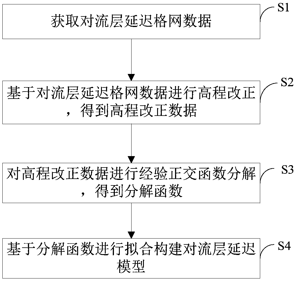
[0082] figure 1 It shows a flow chart of a method for establishing a tropospheric delay model provided by the first embodiment of the present invention, and the establishment method includes:
[0083] Step S1, obtaining tropospheric delay grid data;
[0084] Specifically, the tropospheric delay grid data is first obtained, and the grid data is the data corresponding to the basic zenith tropospheric delay grid product.
[0085] Step S2, performing elevation correction based on the tropospheric delay grid data to obtain elevation correction data;
[0086] Specifically, the elevation correction is performed on the tropospheric delay grid data to obtain the elevation correction data;
[0087] Preferably, using the formula ZTD 0 =ZTD h × exp(βh) performs elevation correction on the basic tropospheric delay grid data, where ZTD h For the underlying tropospheric delay grid data, ZTD 0 It is the elevation correction data, h is the grid point height, β=1.3137×10 -4 .
[0088] I...
Embodiment 2
[0120] Based on the first embodiment above, as Figure 4 As shown, it is a structural diagram of a device for establishing a tropospheric delay model provided by the second embodiment of the present invention. The device for establishing includes: an acquisition unit 1, an improved unit 2 connected to the acquisition unit 1, and a decomposition unit connected to the improved unit 2 3. A construction unit 4 connected to the decomposition unit 3, wherein:
[0121] Acquisition unit 1, used to obtain tropospheric delay grid data;
[0122] Specifically, the tropospheric delay grid data is first obtained, and the grid data is the data corresponding to the basic zenith tropospheric delay grid product.
[0123] The improved unit 2 is used to perform elevation correction based on the tropospheric delay grid data to obtain elevation correction data;
[0124] Specifically, the elevation correction is performed on the tropospheric delay grid data to obtain the elevation correction data;...
Embodiment 3
[0158] Based on the first embodiment above, as Figure 5 A flow chart of a tropospheric delay acquisition method provided by the third embodiment of the present invention is shown, and the acquisition method includes:
[0159] Step A1, constructing a tropospheric delay model;
[0160] Specifically, first construct a tropospheric delay model, which is based on the elevation correction of the tropospheric grid data, and is constructed after empirical orthogonal function decomposition;
[0161] Step A2, obtaining the tropospheric delay based on the constructed tropospheric delay model;
[0162] Specifically, calculate and obtain tropospheric delay data based on the constructed tropospheric delay model;
[0163] In this embodiment, the tropospheric delay model is constructed by using empirical orthogonal function decomposition, which can improve the accuracy of model construction.
[0164] Preferably, the tropospheric delay data is acquired based on the tropospheric delay model...
PUM
 Abstract
Description
Claims
Application Information
 - R&D
- Intellectual Property
- Life Sciences
- Materials
- Tech Scout
- Unparalleled Data Quality
- Higher Quality Content
- 60% Fewer Hallucinations
Browse by: Latest US Patents, China's latest patents, Technical Efficacy Thesaurus, Application Domain, Technology Topic, Popular Technical Reports.
© 2025 PatSnap. All rights reserved.Legal|Privacy policy|Modern Slavery Act Transparency Statement|Sitemap|About US| Contact US: help@patsnap.com


