Basin pollution control unit partitioning method

A pollution control and watershed technology, applied in image data processing, instrumentation, 3D modeling, etc., can solve problems such as pollutant degradation without consideration

Pending Publication Date: 2020-05-26
NANJING INST OF GEOGRAPHY & LIMNOLOGY
View PDF4 Cites 14 Cited by
  • Summary
  • Abstract
  • Description
  • Claims
  • Application Information

AI Technical Summary

Problems solved by technology

The scientific division of watershed pollution control units is the basis for water pollution prevention and water environment restoration in the watershed. However, most of the current pollution control units use the discharge coefficient method to calculate the discharge of different pollution sources, without considering the transport of pollutants along the hydrological path. Degradation by Migration

Method used


Image

  • Basin pollution control unit partitioning method
  • Basin pollution control unit partitioning method
  • Basin pollution control unit partitioning method

Examples


Embodiment 1

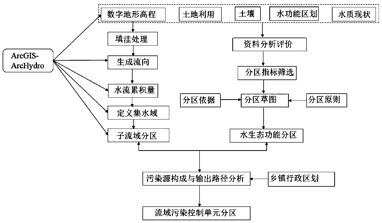
[0031] In this embodiment, the Chaohu Lake watershed is taken as an example to specifically describe the watershed pollution control unit zoning method of the present invention.

[0032] figure 1 Be the flow chart of the inventive method, comprise the steps:

[0033] 1) Divide the sub-basins;

[0034] Using ArcGIS and hydrological analysis technology, based on the digital terrain elevation model of the research basin and the hydrological and water quality monitoring section, the filling process, the generation of flow direction, the accumulation of water flow, the definition of watershed and sub-basin, and the division of sub-basins are carried out in sequence.

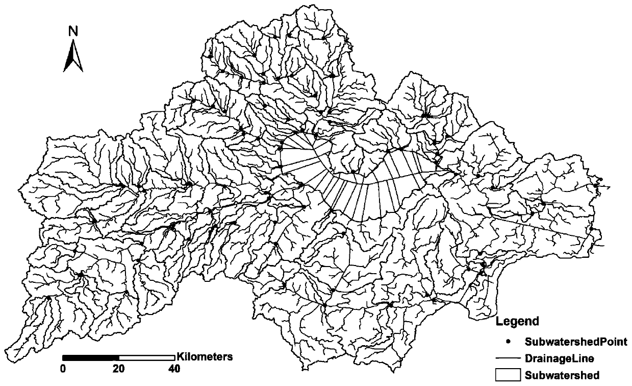
[0035] In this embodiment, a digital terrain elevation model with a grid resolution of 50 m is used as input, and ArcHydro's Terrain Processing, Batch Watershed Delineation and Batch Subwatershed Delineation modules and their Sub-module function, divide sub-watersheds through the following process:

[0036] (1) Gen...


PUM


Abstract

The invention relates to a watershed pollution control unit partitioning method which comprises the following steps: performing sub-watershed zoning and water ecological function zoning on a researchwatershed, and analyzing pollution source composition and pollution load in combination with village and town administrative division; calculating spatial distribution of drainage basin pollution loads by adopting a drainage basin semi-distributed hydrology and pollutant transportation coupling model based on a process, and calculating pollution load spatial distribution of village and town administrative divisions in combination with the village and town administrative divisions; and performing pollution control unit division based on the sub-basin partitions, the water ecological function partitions, the village and town administrative division and the pollution load spatial distribution. According to the method, the difference between hydrological processes and pollutant conversion under different land utilization and different soil types is considered; the river water quality under the combined action of runoff, point source and non-point source of each sub-basin is continuously simulated . the pollution output load of each sub-basin is calculated to the river channel, the village and town administrative division is combined, the village and town subareas are combined with similar pollution source composition and pollution load, and a pollution control unit is divided.

Description

technical field [0001] The invention relates to the fields of river basin hydrology and water environment, in particular to a method for partitioning pollution control units of river basin pollution reduction and water environment restoration. Background technique [0002] The loss of watershed pollutants involves complex hydrological transport and biogeochemical transformation processes. Due to the spatial differences in pollution sources, land use, meteorology and hydrology, and agricultural management measures, the loss of pollutants presents large spatial variations. The formulation of precise emission reduction programs for watershed pollution and water quality management depend on the scientific understanding of the natural geographical characteristics of the watershed, meteorology and hydrology, the composition and transport characteristics of pollution sources, and their spatial distribution. my country's river basin water quality management technology began in the ...

Claims


Application Information

Patent Timeline
Patent Type & Authority Applications(China)
IPC IPC(8): G06Q10/06G06Q50/26G06T17/05
CPCG06Q10/0637G06Q10/0639G06Q50/26G06T17/05Y02A20/152
Inventor 姜三元李恒鹏
Owner NANJING INST OF GEOGRAPHY & LIMNOLOGY
Why Eureka
Try Eureka