Air route planning method for multi-unmanned aerial vehicle target positioning

A technology for target positioning and route planning, applied in three-dimensional position/channel control, vehicle position/route/altitude control, navigation calculation tools, etc., can solve problems such as poor practicability, achieve fast planning speed, small amount of calculation, and less information Effect

Active Publication Date: 2020-06-02
NORTHWESTERN POLYTECHNICAL UNIV
View PDF9 Cites 5 Cited by
  • Summary
  • Abstract
  • Description
  • Claims
  • Application Information

AI Technical Summary

Problems solved by technology

[0004] In order to overcome the shortcomings of poor practicability of the existing UAV route plann

Method used


Image

  • Air route planning method for multi-unmanned aerial vehicle target positioning
  • Air route planning method for multi-unmanned aerial vehicle target positioning
  • Air route planning method for multi-unmanned aerial vehicle target positioning

Examples


Embodiment Construction

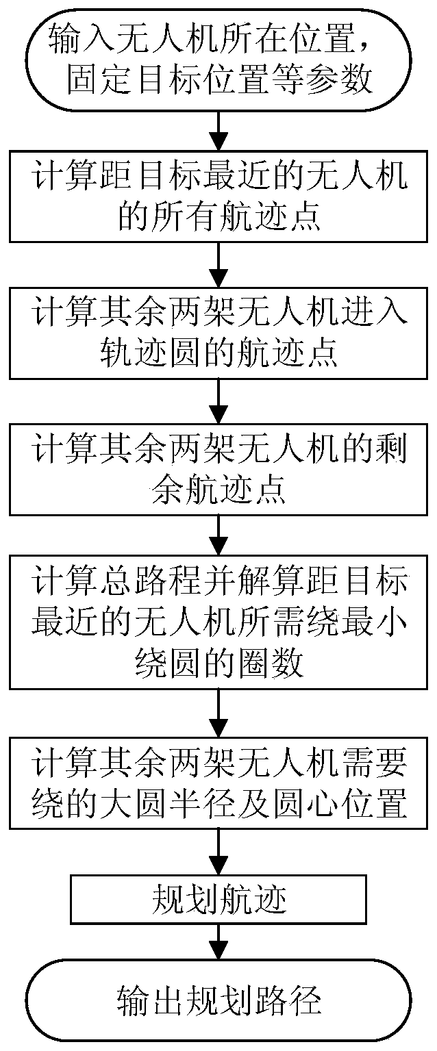
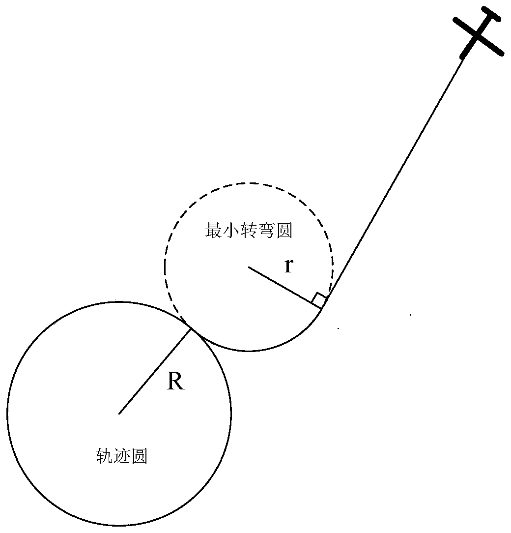
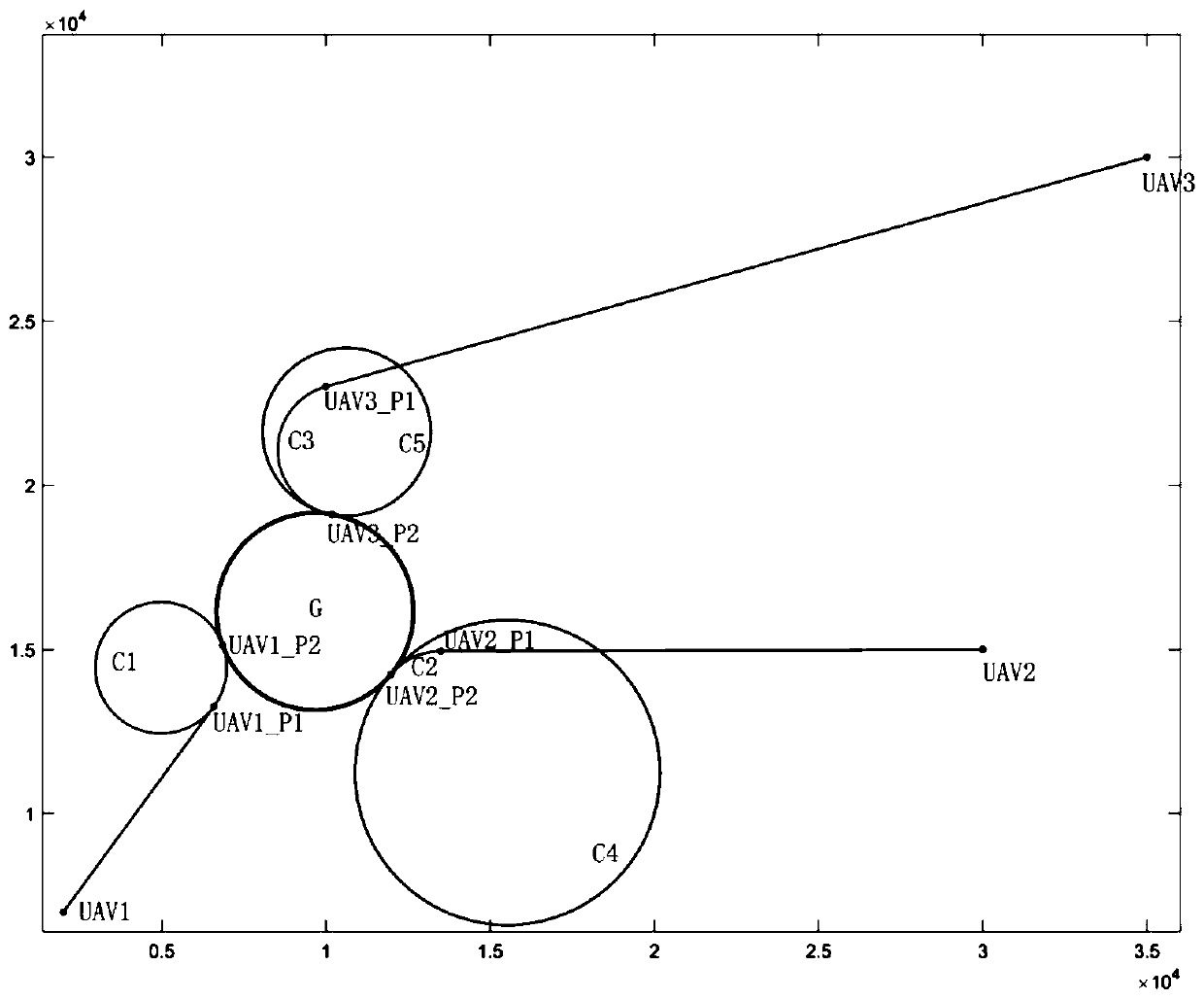
[0045] refer to Figure 1-3 .

[0046] After the UAV searches for the target, the three UAVs themselves are randomly distributed according to a certain rule, and the three UAVs are in a diagonal formation configuration. First, determine the direction in which the UAV flies around the target, and then Plan the track points for each drone.

[0047] The specific steps of the route planning method of multi-UAV target positioning of the present invention are as follows:

[0048] Step 1: Obtain the location information of the UAV by the navigation system of the UAV, and the approximate location of the ground fixed target obtained by searching. Obtain the drone's flight speed, maximum roll angle, and radius of the trajectory circle flying around a fixed target as initialization parameters. Assume that the routes of three UAVs need to be planned.

[0049] Step 2: Assume that the three UAVs are numbered {UAV1, UAV2, UAV3}, and their position coordinates are {[x1, y1], [x2, y2], [x3...


PUM


Abstract

The invention discloses an air route planning method for multi-unmanned aerial vehicle target positioning, which is used for solving the technical problem of poor practicability of an existing unmanned aerial vehicle air route planning method. According to the technical scheme, the method comprises the steps of firstly, enabling a navigation system of an unmanned aerial vehicle to obtain the position information of the unmanned aerial vehicle, and searching to obtain the approximate position of a ground fixed target; and obtaining the flight speed v, the maximum roll angle and the radius R ofa trajectory circle flying around the fixed target of the unmanned aerial vehicle as the initialization parameters. Under the condition that the initial positions of the multiple unmanned aerial vehicles are random, it can be guaranteed that the multiple unmanned aerial vehicles can rapidly reach the space above the target, and an equidistant formation configuration on a trajectory circle is rapidly formed. According to the method, the information needed by planning is little, the engineering implementation is easy, the calculated amount is very small, and the planning speed is high; the formed planned road section only has a straight line section and a curved line section, the flight distance is as short as possible, the flight time is as short as possible, and the practicability is good.

Description

technical field [0001] The invention relates to a route planning method for an unmanned aerial vehicle, in particular to a route planning method for multi-unmanned aerial vehicle target positioning. Background technique [0002] As the use of drones becomes more and more widespread, drones also play an important role in some fields. The research on its route planning can be used in the process of UAV positioning ground targets. Since fixed-wing UAVs are not flexible enough and have more constraints compared with rotary-wing UAVs, the UAV Research on flight path planning can effectively reduce the time for UAVs to reach their destinations and improve the efficiency of UAVs in performing tasks. At present, the route planning of UAVs is relatively mature, but most of the methods have a large amount of calculation and lead to long calculation time, which cannot meet the needs of UAV target positioning and circling flight route planning. So how to quickly plan a feasible UAV pa...

Claims


Application Information

Patent Timeline
IPC IPC(8): G05D1/10G01C21/20
CPCG05D1/104G01C21/20
Inventor 席庆彪宋源杰孙颖杨兵蔡迎哲
Owner NORTHWESTERN POLYTECHNICAL UNIV
Why Eureka
Try Eureka