Information processing system for rapid determination of forest fires

An information processing system and forest fire technology, applied in radio wave measurement systems, fire alarms, positioning, etc., can solve the problems of large positioning errors and time-consuming in fire areas, and achieve image display, speed, and reliability Improved effect

Inactive Publication Date: 2009-10-28
SHANGHAI INST OF TECHNICAL PHYSICS - CHINESE ACAD OF SCI
View PDF0 Cites 12 Cited by
  • Summary
  • Abstract
  • Description
  • Claims
  • Application Information

AI Technical Summary

Problems solved by technology

This method obtains a relatively large error in the positioning of the fire area and due to a large number of manual operations, it takes a lot of time

Method used


Image

  • Information processing system for rapid determination of forest fires
  • Information processing system for rapid determination of forest fires
  • Information processing system for rapid determination of forest fires

Examples


Embodiment Construction

[0024] A better implementation example of the present invention is given below in conjunction with the accompanying drawings to illustrate the structural features of the present invention, rather than to limit the scope of the present invention.
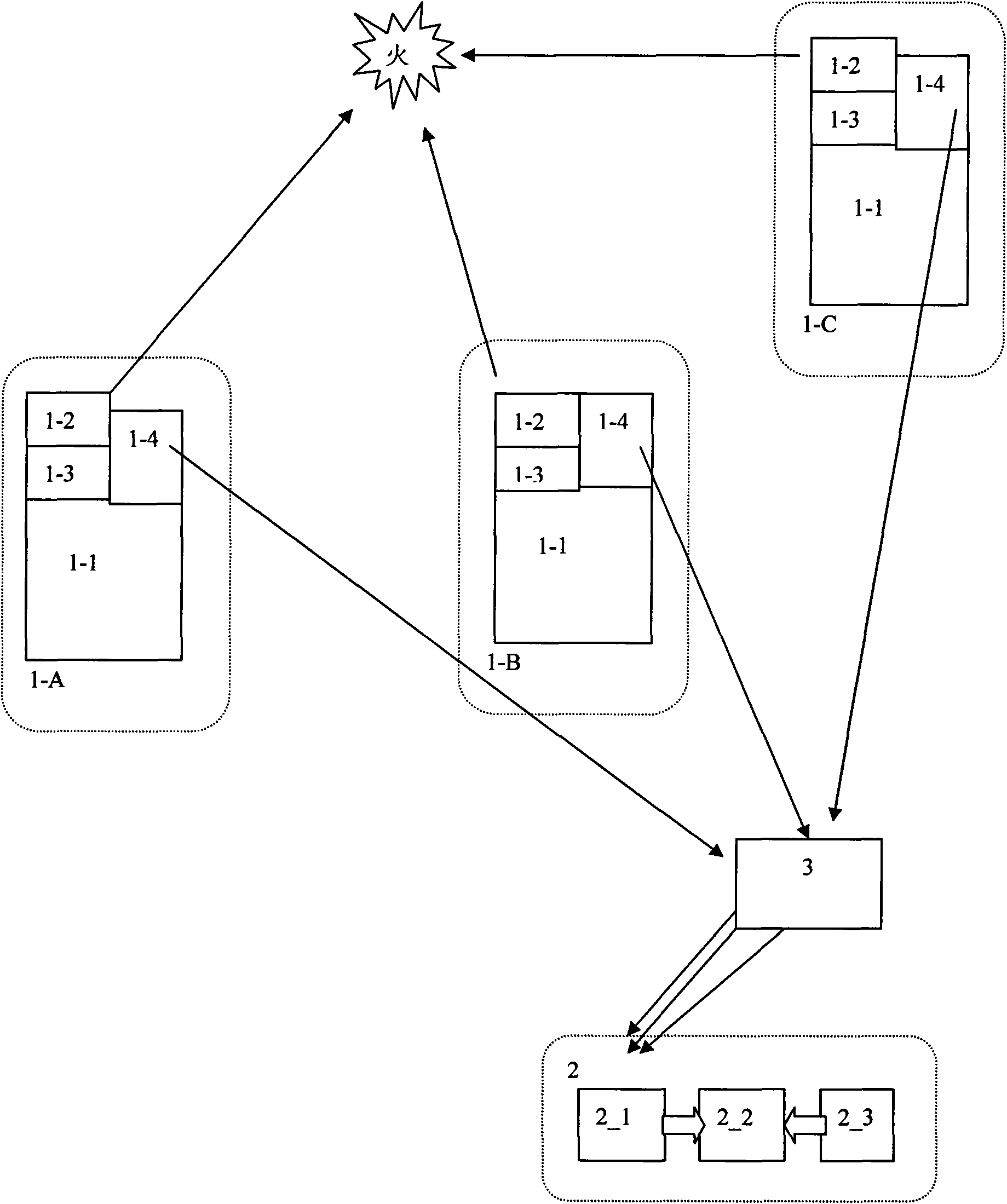
[0025] 1 Watchtower

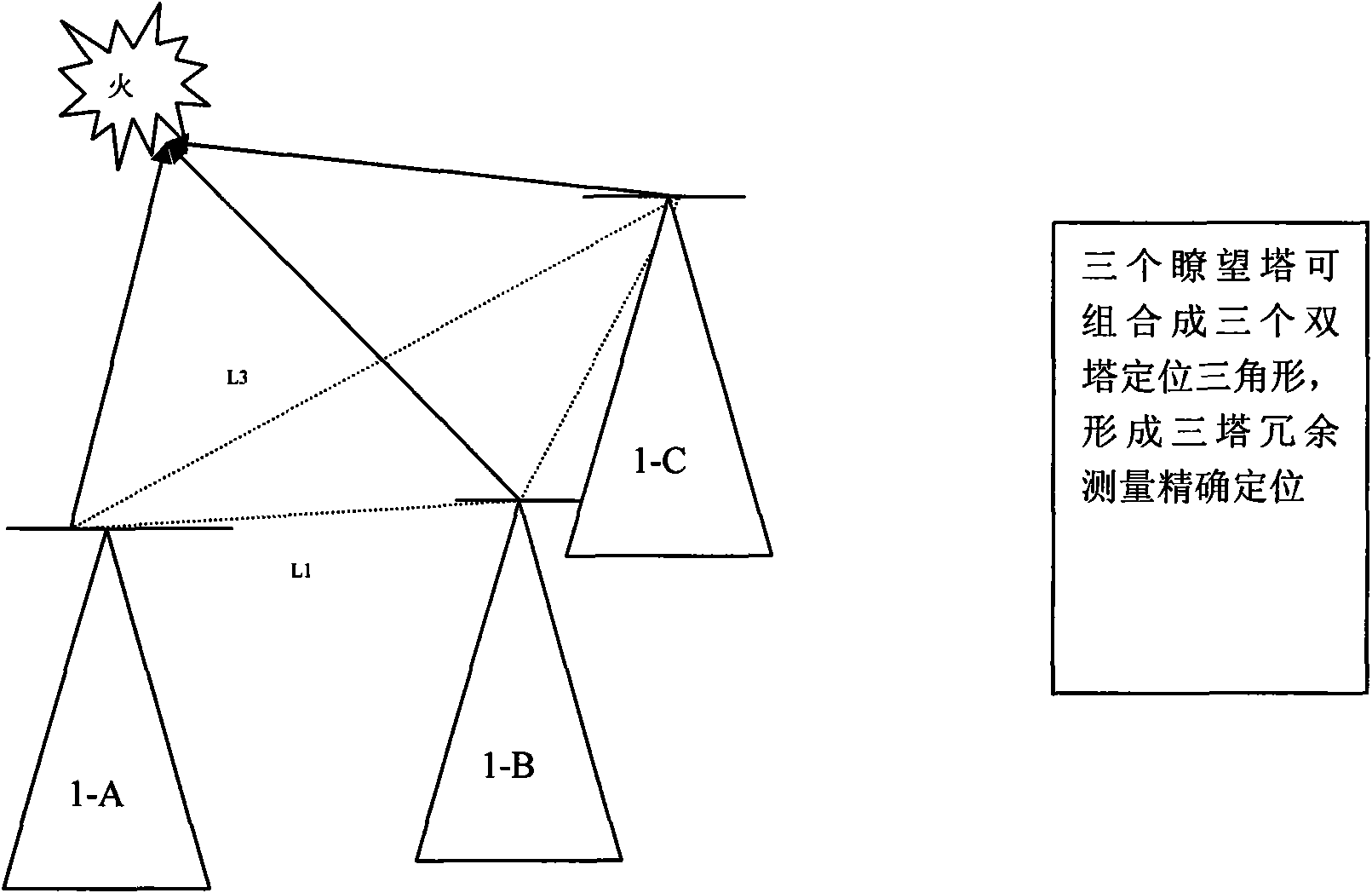
[0026] Generally, a watchtower is set up on an area of ​​5,000 to 15,000 hectares, and the area can be reduced in forests that need to be strengthened for protection. The distance between two watchtowers is generally 5-8km, and should not exceed 8-12km. Because the maximum distance to see the bonfire is 25km away from the sun, and no more than 8-10km when facing the sun. Linta is 22 meters high. It is built on a higher ground, while avoiding that the three watchtowers are distributed on the same straight line.

[0027] 2 tower load equipment

[0028] The technical parameters of the tower-mounted photoelectric angle measuring equipment are set as follows:

[0029] Photoelectric goniometric observation unit: ...


PUM


Abstract

The invention discloses an information processing system for rapid determination of forest fires, which comprises three observation towers, a command center and a communication system. Devices which are carried on each observation tower comprise a high-precision photoelectric angle detection unit, a panoramic observation unit and a positioning and communication device. The positioning of forest fire areas adopts a three-station redundant measurement technology. The information processing system adopts a GPS/Beidou dual-module positioning technology to enable static positioning accuracy to reach millimeter grade, and utilizes the communication function of the Beidou system to send measured data to the command center which can rapidly calculate the position of the fire area by combining GIS software and database after receiving the data. The information processing system can rapidly and precisely locate positions of fire areas and has very large practical application value for forest fire fighting and rescue work.

Description

Technical field: [0001] The present invention relates to geographic location measurement technology, specifically a forest fire rapid measurement information processing system, which uses two watchtower cross rough positioning technology, three watchtower redundant measurement high-precision positioning technology, GPS / Beidou high-precision positioning The watchtower's own location technology and the Beidou communication system data transmission technology are the core, and it is a system that can quickly and accurately measure the location of forest fire areas. Background technique: [0002] Forests are precious resources for human beings, but forest fires are caused every year due to natural or man-made reasons, and large areas of forests are burned down. Most forest fires are caused by large-scale fires because small fires cannot be detected and extinguished in time. With the remarkable progress of science and technology, the technology of using satellites to monitor and...

Claims


Application Information

Patent Timeline
Patent Type & Authority Applications(China)
IPC IPC(8): G08B25/00G08B17/00G01S5/02G01C1/00
Inventor 徐贵州张雷王建宇
Owner SHANGHAI INST OF TECHNICAL PHYSICS - CHINESE ACAD OF SCI
Why Eureka
Try Eureka