Method for improving regional groundwater reserve estimation precision

A technology of reserves estimation and groundwater, applied in the intersection of satellite gravity and hydrology, can solve the problems of difficult to reliably estimate groundwater reserves and uneven distribution of groundwater level monitoring wells, and achieve the effect of improving estimation accuracy.

Active Publication Date: 2020-06-05
CHINA ACADEMY OF SPACE TECHNOLOGY
View PDF4 Cites 7 Cited by
  • Summary
  • Abstract
  • Description
  • Claims
  • Application Information

AI Technical Summary

Problems solved by technology

Therefore, understanding the dynamic changes of GWS is of great significance to the local ecological environment, and it is difficult to reliably estimate groundwater storage using well observations due to the uneven distribution of groundwater level monitoring wells

Method used


Image

  • Method for improving regional groundwater reserve estimation precision
  • Method for improving regional groundwater reserve estimation precision
  • Method for improving regional groundwater reserve estimation precision

Examples


Embodiment Construction

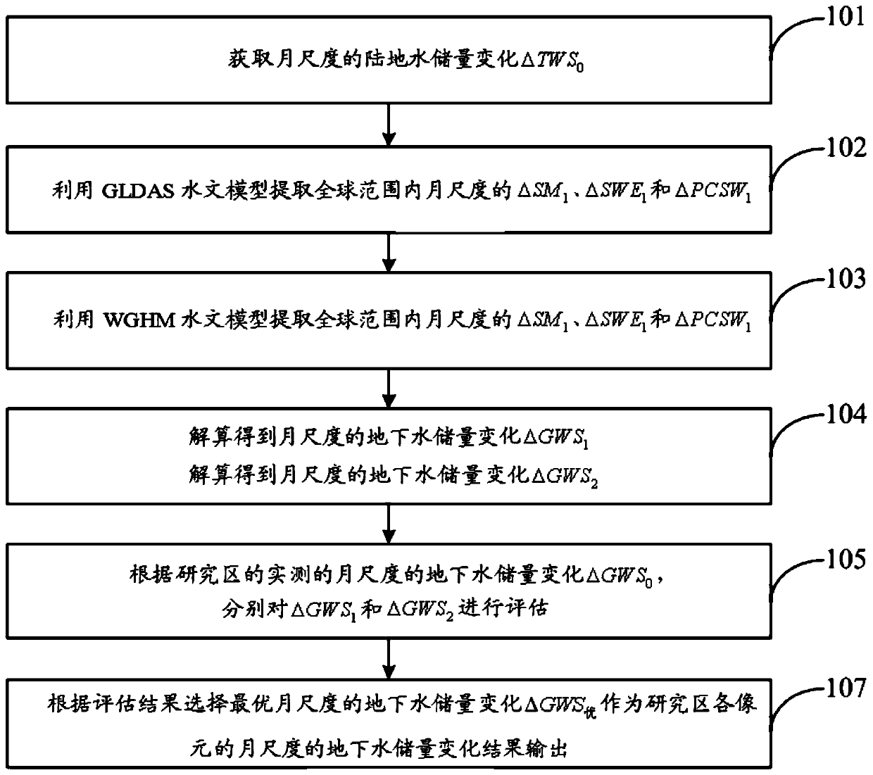
[0059] In order to make the object, technical solution and advantages of the present invention clearer, the embodiments disclosed in the present invention will be further described in detail below in conjunction with the accompanying drawings.

[0060] In the present invention, a method for improving the estimation accuracy of regional groundwater storage disclosed in this embodiment is mainly described through the following aspects.

[0061] 1. Overview of the research area

[0062] Tasmania is located 240km south of mainland Australia, with a latitude and longitude range of 40°S-44°S and 144°E-148°E, and an area of ​​64,500 km 2 . Most of the area is high mountains and hills, the center is the highest part of the area, with peaks over 1500m above sea level, and the central and eastern regions and coastal areas are relatively flat.

[0063] The climate type of Tasmania is a temperate maritime climate, cool and mild, with an average annual temperature as high as 15.7°C and a...


PUM


Abstract

The invention discloses a method for improving regional groundwater reserve estimation precision. The method comprises the following steps of: acquiring monthly-scale land water reserve change delta TWS0; extracting monthly-scale soil water content change delta SM1, snow water equivalent change delta SWE1 and vegetation canopy water reserve change delta PCSW1 in a global range by utilizing a GLDAShydrological model; extracting monthly-scale soil water content change delta SM2, snow water equivalent change delta SWE2 and vegetation canopy water reserve change delta PCSW2 in a global range by utilizing a WGHM hydrological model; calculating to obtain monthly-scale underground water reserve changes delta GWS1 and delta GWS2; evaluating the delta GWS1 and the delta GWS2 respectively accordingto the actually measured monthly-scale groundwater reserve change delta GWS0 in a research region; and selecting the optimal monthly-scale groundwater reserve change delta GWS as a monthly-scale groundwater reserve change result of each pixel of the research region according to the evaluation result, and outputting the monthly-scale groundwater reserve change result. According to the method, theestimation precision of the regional groundwater reserves is improved based on the statistical selection method in combination with GRACE satellite gravity data and a global hydrological model.

Description

technical field [0001] The invention belongs to the interdisciplinary technical field of satellite gravity and hydrology, and in particular relates to a method for improving the estimation accuracy of regional groundwater storage. Background technique [0002] Groundwater (GWS) is the largest freshwater resource in the global hydrological cycle, providing approximately 50% of the world's drinking water. In recent years, extreme climate, population growth, and excessive exploitation of groundwater resources have led to serious consumption of groundwater resources. Therefore, mastering the dynamic changes of groundwater is crucial to water resource management and human survival. [0003] Traditional groundwater change monitoring methods mainly rely on observation wells. Although the results can provide high-resolution groundwater level estimates, there are many limitations in practical applications. First, the construction and maintenance of observation wells are time-consum...

Claims


Application Information

Patent Timeline
Patent Type & Authority Applications(China)
IPC IPC(8): G06F17/18
CPCG06F17/18
Inventor 郑伟尹文杰李钊伟吴凡
Owner CHINA ACADEMY OF SPACE TECHNOLOGY
Why Eureka
Try Eureka