Ionospheric tomography method based on vertical measurement data constraint

A tomography, data-constrained technology, used in measurement devices, radiation measurement, radio wave measurement systems, etc., can solve the problems of poor ionospheric peak accuracy and low vertical resolution.

Active Publication Date: 2020-06-12
中国电波传播研究所
View PDF5 Cites 22 Cited by
  • Summary
  • Abstract
  • Description
  • Claims
  • Application Information

AI Technical Summary

Problems solved by technology

Especially due to the high orbital height of GNSS satellites, for a specific area, the ray paths corresponding to most of the observation data are nearly vertical compared with the CT imaging grid. According to the theory of ionospheric tomography, This will result in lower vertical resolution achieved by ground-based GNSS imaging, that is, less accurate retrieval of ionospheric peaks

Method used


Image

  • Ionospheric tomography method based on vertical measurement data constraint
  • Ionospheric tomography method based on vertical measurement data constraint
  • Ionospheric tomography method based on vertical measurement data constraint

Examples


Embodiment Construction

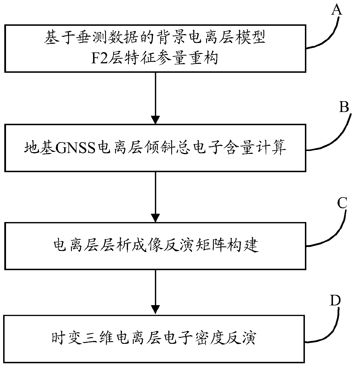
[0173] In order to make the objectives, technical solutions, and advantages of the present invention clearer, the following further describes the present invention in detail with reference to the accompanying drawings and embodiments. It should be understood that the specific embodiments described herein are only used to explain the present invention, but not to limit the present invention.

[0174] In order to improve the vertical resolution of ionospheric 3D CT imaging, an important method is to add other observation data with higher vertical resolution for imaging constraints, such as adding ionospheric vertical measurement data to improve the vertical resolution of ionospheric tomography . With the construction of global GPS, GLONASS, Beidou, GALILEO and other navigation systems, the measurement data based on the global GNSS system is becoming more and more abundant. At present, the GNSS observation data of more than 300 stations can be obtained online; at the same time, the ...


PUM


Abstract

The invention discloses an ionospheric tomography method based on vertical measurement data constraint. The method comprises the following steps: step A, reconstructing F2-layer characteristic parameters of a background ionized layer model based on vertical measurement data; step B, calculating the total electron content of ground-based GNSS ionospheric inclination; step C, constructing an ionospheric tomography inversion matrix; the invention discloses an ionospheric tomography method based on vertical measurement data constraint. Ionosphere vertical measurement data published by a global radio ionosphere observation station and ground-based GNSS observation data published by an International Global Service (IGS) are used as data sources of ionosphere tomography. The ionospheric tomography background model is updated by utilizing the vertical measurement data; the background ionosphere model is corrected by using an improved multiplication algebraic iterative algorithm in combinationwith the inclined total electron content data of the ground-based GNSS, and regional and even global ionosphere tomography is realized, so that the spatial-temporal change characteristics of the totalelectron content and electron density of the ionosphere are obtained.

Description

Technical field [0001] The invention belongs to the field of space ionospheric environmental monitoring, and particularly relates to an ionospheric tomography imaging method based on vertical measurement data constraints in this field. Background technique [0002] As an important part of the solar-terrestrial space environment, the ionosphere will produce effects such as refraction, reflection, scattering and absorption of radio waves passing through it, thereby affecting the performance of many radio information systems such as satellite navigation, communications, and radar. The use of various technical means to obtain the characteristic parameters of the ionosphere, study various phenomena in the ionosphere, and reveal the physical mechanism behind it, has important scientific and even political, military and economic significance. Among the many characteristic parameters of the ionosphere, the ionospheric electron density is the most critical detection parameter. The mastery...

Claims


Application Information

Patent Timeline
Patent Type & Authority Applications(China)
IPC IPC(8): G01T1/29G01S19/37
CPCG01S19/37G01T1/2985G01T1/2992
Inventor 欧明韩超陈亮冯健熊雯於晓刘钝陈龙江宋方雷陈丽甄卫民
Owner 中国电波传播研究所
Why Eureka
Try Eureka