
Quantitative evaluation method for spatial-temporal differentiation effect of earth surface thermal environment based on pixel trisection model

A technique for quantitative evaluation, surface heat, applied in image detector methods and image signal processing, radiation pyrometry, analysis of materials, etc.

Pending Publication Date: 2020-07-10
NORTH CHINA UNIVERSITY OF SCIENCE AND TECHNOLOGY
View PDF3 Cites 3 Cited by
  • Summary
  • Abstract
  • Description
  • Claims
  • Application Information

AI Technical Summary

Problems solved by technology

In the current research on the differentiation effect of regional surface thermal environment, non-photosynthetic vegetation is taken as a component, and the mixed pixels of medium-resolution multispectral remote sensing images are decomposed into photosynthetic / non-photosynthetic vegetation and bare soil based on the pixel three-part model There are few reports on the inversion of vegetation coverage by these three components and the analysis of their evolution with the spatio-temporal differentiation effect of surface thermal environment in mining intensive areas

Method used


Image

  • Quantitative evaluation method for spatial-temporal differentiation effect of earth surface thermal environment based on pixel trisection model
  • Quantitative evaluation method for spatial-temporal differentiation effect of earth surface thermal environment based on pixel trisection model
  • Quantitative evaluation method for spatial-temporal differentiation effect of earth surface thermal environment based on pixel trisection model

Examples


Embodiment Construction

[0069] The following will clearly and completely describe the technical solutions in the embodiments of the present invention with reference to the accompanying drawings in the embodiments of the present invention. Obviously, the described embodiments are only some, not all, embodiments of the present invention. Based on the embodiments of the present invention, all other embodiments obtained by persons of ordinary skill in the art without making creative efforts belong to the protection scope of the present invention.

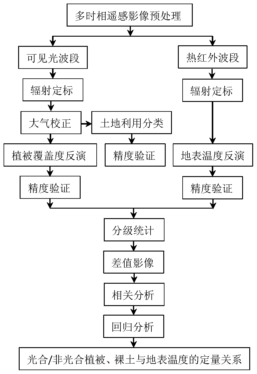
[0070] A method for quantitatively evaluating the spatio-temporal differentiation effect of the surface thermal environment in mining development-intensive areas based on the pixel three-part model established by using remote sensing technology. Carry out preprocessing, perform radiometric calibration and atmospheric correction on the visible light band, convert the gray value of the pixel into a radiance value, eliminate the influence of the atmosphere, and us...


PUM


Abstract

The invention discloses a quantitative evaluation method for a s spatial-temporal differentiation effect of earth surface thermal environment based on a pixel trisection model. The vegetation coverageof a mining development dense area is estimated by using a pixel trisection model; an NDVI-DFI feature space is constructed to extract an end member feature value; and a mixed pixel on a medium-resolution remote sensing image is decomposed into three parts, namely photosynthetic / non-photosynthetic vegetation and bare soil. The estimation conforms to actual situations, the capability of obtainingvegetation information through remote sensing is enhanced, the spatial-temporal differentiation characteristic relation of photosynthetic / non-photosynthetic vegetation and bare soil to the regional earth surface thermal environment is evaluated quantitatively, and a quantitative reference basis is provided for revealing an influence mechanism of photosynthetic / non-photosynthetic vegetation and bare soil to the spatial-temporal heterogeneity of the earth surface thermal environment in a mining development dense region.

Description

technical field [0001] The invention relates to a quantitative evaluation method for the spatiotemporal differentiation effect of the surface thermal environment, in particular to a quantitative evaluation method for the spatiotemporal differentiation effect of the surface thermal environment in a mining development-intensive area based on a pixel three-part model. Background technique [0002] Land surface temperature (LST) and vegetation fractional coverage (VFC) are important indicators of ecological environment change. The study of their temporal and spatial changes and their relationship is of great significance for evaluating regional ecological environment construction and improving regional ecological environment quality. Significance. [0003] Vegetation coverage affects both surface energy exchange and surface heat flow, and is an important factor affecting surface temperature. Based on various vegetation indexes, such as normalized difference vegetation index (ND...

Claims


Application Information

Patent Timeline
IPC IPC(8): G01N21/25G01J5/00
CPCG01N21/25G01J5/00G01N2021/1797G01N2021/1765G01J2005/0077G01J5/485
Inventor 侯春华李富平谷海红李小光周淑青张丽春赵菁菁宋文
Owner NORTH CHINA UNIVERSITY OF SCIENCE AND TECHNOLOGY
Learn More