
Sea surface chlorophyll transmission track simulation method

A technology for chlorophyll and chlorophyll concentration, which is applied in the fields of marine technology and satellite remote sensing, and can solve problems such as time-consuming and labor-intensive

Active Publication Date: 2020-07-24
三亚中科遥感研究所 +1
View PDF4 Cites 4 Cited by
  • Summary
  • Abstract
  • Description
  • Claims
  • Application Information

AI Technical Summary

Problems solved by technology

However, the existing chlorophyll transport process often relies on numerical simulation of high-resolution bio-physical coupling models, and it is time-consuming and labor-intensive to establish a reliable local high-precision coupling simulation system

Method used


Image

  • Sea surface chlorophyll transmission track simulation method
  • Sea surface chlorophyll transmission track simulation method
  • Sea surface chlorophyll transmission track simulation method

Examples


Embodiment Construction

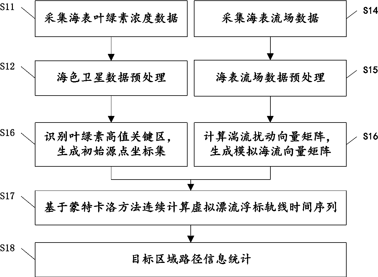
[0027] The implementation of the sea surface chlorophyll path simulation technology of the present invention will be described in detail below with reference to the accompanying drawings.

[0028] During the research, it was found that the advective transport of chlorophyll on the sea surface is mainly driven by the upper ocean, especially the ocean surface currents, and the advective movement of the chlorophyll concentration on the sea surface can be well represented by using the virtual drift float. The Lagrangian trajectory of the buoy is used to simulate and predict the transportation path of the concentration of chlorophyll on the sea surface.

[0029] The following will clearly and completely describe the technical solutions in the embodiments of the present invention with reference to the accompanying drawings in the embodiments of the present invention. Obviously, the described embodiments are only some, not all, embodiments of the present invention. Based on the embod...


PUM


Abstract

The invention provides a sea surface chlorophyll transmission path simulation method based on satellite observation data. Sea surface chlorophyll concentration obtained by remote sensing observation of a satellite-borne sensor is used as an initial source point; based on a sea surface flow field based on satellite observation and numerical simulation, random disturbance caused by turbulence is considered; the transmission distance of chlorophyll is subjected to transmission distance continuous simulation based on a Monte Carlo method, and the horizontal transport vector time sequence of chlorophyll in a preset target area in a preset period is determined, so that reliable simulation of a sea surface chlorophyll concentration transmission path is realized, and chlorophyll path simulation prediction can be realized quickly, accurately and reliably.

Description

technical field [0001] The invention relates to the fields of marine technology and satellite remote sensing technology, in particular to a method and device for simulating a sea surface chlorophyll horizontal transport path. Background technique [0002] Ocean remote sensing (ocean remote sensing) uses sensors to conduct long-distance non-contact observations of the ocean to obtain images or data of ocean landscapes and ocean elements. The ocean continuously radiates electromagnetic wave energy to the environment, and the sea surface also reflects or scatters electromagnetic wave energy from the sun and artificial radiation sources (such as radar), so some special sensors can be designed and loaded on artificial satellites, spacecraft, aircraft, rockets, etc. The electromagnetic radiation energy is received and recorded on working platforms carried by balloons and balloons, and then transmitted, processed and processed to obtain ocean images or data. [0003] Marine remote...

Claims


Application Information

Patent Timeline
IPC IPC(8): G06F30/20G01M10/00G06F113/08
CPCG01M10/00
Inventor 沙金李晓明
Owner 三亚中科遥感研究所
Learn More