
Two-dimensional and three-dimensional GIS service platform

A service platform, three-dimensional data technology, applied in the field of urban transportation

Active Publication Date: 2020-07-28
深圳市百纳九洲科技有限公司
View PDF8 Cites 3 Cited by
  • Summary
  • Abstract
  • Description
  • Claims
  • Application Information

AI Technical Summary

Problems solved by technology

[0003] The present invention provides a two-dimensional and three-dimensional GIS service platform, which is used to solve the situation that urban traffic cannot be efficiently predicted from the aspects of personnel trajectory, vehicle ownership, regional economy, etc., and prevent traffic jams and traffic accidents

Method used


Image

  • Two-dimensional and three-dimensional GIS service platform
  • Two-dimensional and three-dimensional GIS service platform

Examples


Embodiment Construction

[0065] The preferred embodiments of the present invention will be described below in conjunction with the accompanying drawings. It should be understood that the preferred embodiments described here are only used to illustrate and explain the present invention, and are not intended to limit the present invention.

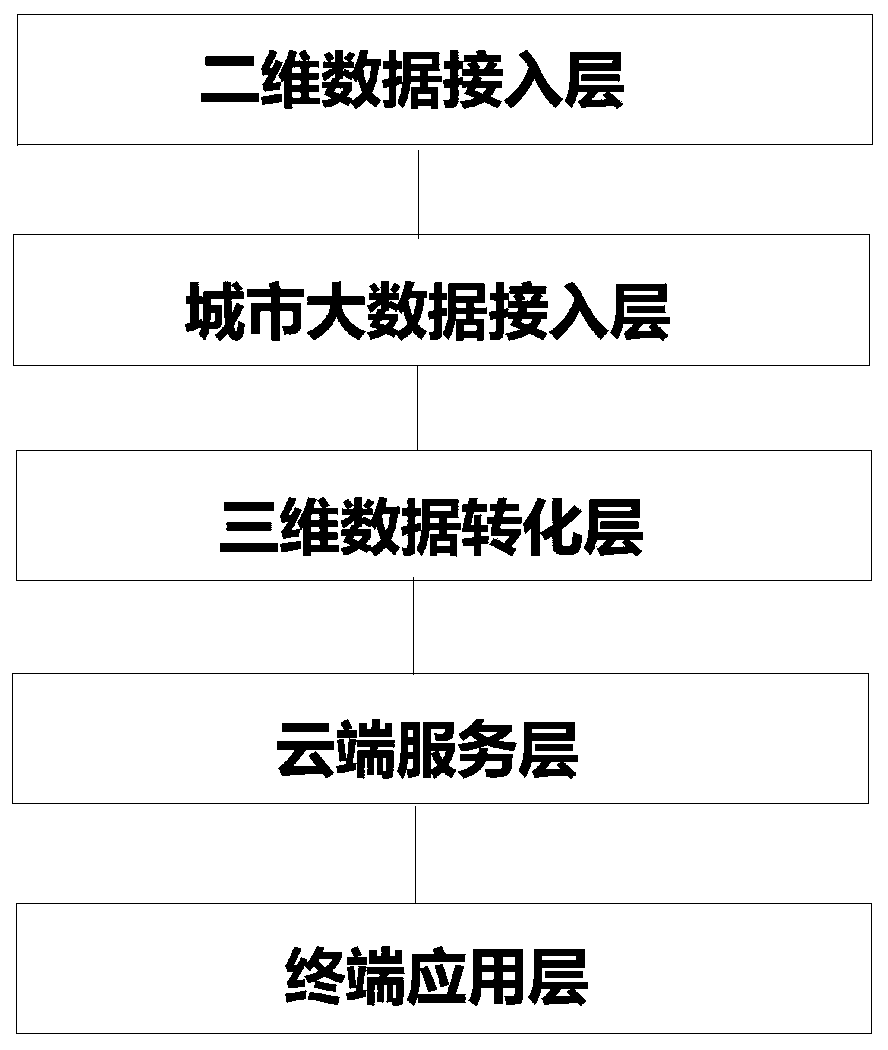
[0066] as attached figure 1 A schematic structural diagram of a 2D and 3D GIS service platform is shown, including:

[0067] Two-dimensional data access layer: used to obtain multi-source GIS information data, wherein the GIS information data at least include: satellite remote sensing images, UAV monitoring images and map data;

[0068] Urban big data access layer: used to obtain urban comprehensive data, wherein the urban comprehensive data at least includes: urban traffic data, urban enterprise data and urban economic data, the present invention can be connected to more data systems during actual implementation, It is not limited to the three described in the pr...


PUM


Abstract

The invention provides a two-dimensional and three-dimensional GIS service platform, and the platform comprises: a two-dimensional data access layer which is used for obtaining multi-source GIS information data which at least comprises a satellite remote sensing image, an unmanned plane monitoring image, and map data; a city big data access layer which is used for acquiring city comprehensive data, wherein the city comprehensive data at least comprises city traffic data, city enterprise data and city economic data; a three-dimensional data conversion layer which is used for importing the GIS information data into 3D modeling software to construct a three-dimensional space model and importing the city comprehensive data into the three-dimensional space model to form a three-dimensional dataspace composed of a plurality of databases; a cloud service layer which is used for constructing a cloud network and a multi-source heterogeneous service service system, wherein the multi-source heterogeneous service service system is connected with the three-dimensional data space for communication through the cloud network; and a terminal application layer which is used for constructing a communication channel between the three-dimensional data space and external terminal equipment.

Description

technical field [0001] The invention relates to the field of urban traffic, in particular to a two-dimensional and three-dimensional GIS service platform. Background technique [0002] Currently, Modern cities need to meet the needs of urban residents in all aspects of life, among which traffic demand is one of the most important needs. In urban traffic, GIS, as a geographic information system, can perform remote sensing mapping and data analysis functions for urban traffic congestion and traffic accidents. With the economic development and the increase of personal vehicle ownership, the data of real-time monitoring of urban traffic in the existing technology can only play a real-time monitoring function for urban traffic, but the early warning effect for urban traffic is very low. For urban traffic, it is impossible to make efficient predictions from the aspects of personnel trajectory, vehicle ownership, regional economy, etc., to prevent traffic jams and traffic acciden...

Claims


Application Information

Patent Timeline
Patent Type & Authority Applications(China)
IPC IPC(8): G06F16/29G06Q10/04G06Q50/26
CPCG06Q10/04G06Q50/26G06F16/29
Inventor 梁明龙
Owner 深圳市百纳九洲科技有限公司
Learn More