Cadastral measurement method for applying aerial photography of unmanned aerial vehicle to 1: 500

A cadastral survey and unmanned aerial vehicle technology, applied in the field of unmanned aerial vehicle surveying and mapping, can solve the problems of difficult implementation, high dependence on weather environment, harsh and complex environment of cadastral survey area, etc., and achieve the effect of novel design

Inactive Publication Date: 2020-07-31
无锡吉图测绘科技有限公司
View PDF0 Cites 1 Cited by
  • Summary
  • Abstract
  • Description
  • Claims
  • Application Information

AI Technical Summary

Problems solved by technology

[0006] Based on this, aiming at the prior art, the present invention provides a cadastral measurement method using drone aerial photography at 1:500 scale. The survey requires a large number of skilled field surveyors, high cost of implementation, harsh and complex environment in the cadastral survey area, difficult implementation and high dependence on the weather environment

Method used


Image

  • Cadastral measurement method for applying aerial photography of unmanned aerial vehicle to 1: 500
  • Cadastral measurement method for applying aerial photography of unmanned aerial vehicle to 1: 500

Examples


Embodiment Construction

[0021] In order to make the technical means, creative features, purpose and means achieved by the present invention easy to understand, the present invention will now be further described in detail in conjunction with the accompanying drawings. These drawings are all simplified schematic diagrams, which only illustrate the basic structure of the present invention in a schematic manner, so they only show the configurations related to the present invention.

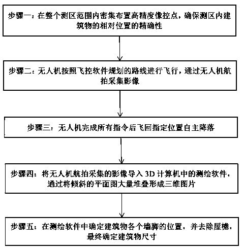
[0022] See figure 1 , a method of cadastral surveying applied to 1:500 aerial photography by unmanned aerial vehicles, the specific steps are as follows:

[0023] Step 1: Densely arrange high-precision image control points within the entire survey area to ensure the accuracy of the relative positions of buildings in the survey area;

[0024] Step 2: The UAV flies according to the route planned by the flight control software, and collects images through UAV aerial photography;

[0025] Step 3: After completing all instruct...


PUM


Abstract

The invention discloses a cadastral measurement method for applying aerial photography of an unmanned aerial vehicle to 1: 500. The method comprises the following specific steps: 1) densely arranginghigh-precision image control points in the range of a whole measurement area to ensure the accuracy of the relative position of a building in the measurement area; 2) the unmanned aerial vehicle flying according to a route planned by flight control software, and acquiring images through aerial photography of the unmanned aerial vehicle; 3) the unmanned aerial vehicle flying back to a designated position to land autonomously after completing all the instructions; 4) importing an image acquired by aerial photography of the unmanned aerial vehicle into surveying and mapping software in a 3D computer, and forming a three-dimensional picture by stacking a large number of inclined plane graphs; and 5) determining the position of each wall foot of the building in surveying and mapping software, removing eaves, and finally determining the size of the building. The system is novel in design, applying unmanned aerial vehicle surveying and mapping to cadastral survey. The problems that a large number of skilled field survey personnel are needed in traditional cadastral survey, the implementation cost is high, the cadastral survey area environment is severe and complex, the implementation difficulty is large, and the degree of dependence on the weather environment is high are solved.

Description

technical field [0001] The invention relates to the technical field of unmanned aerial vehicle surveying and mapping, in particular to a cadastral measurement method for aerial photography of an unmanned aerial vehicle applied to 1:500. Background technique [0002] Unmanned aircraft is referred to as "UAV" for short, and the English abbreviation is "UAV". . Compared with manned aircraft, UAVs are often more suitable for missions in areas with harsh, complex environments and poor visibility conditions. UAVs can be divided into military and civilian applications according to their application fields. In terms of civilian use, drones + industry applications are the real rigid needs of drones; currently, they are used in aerial photography, agriculture, plant protection, micro selfies, express delivery, disaster relief, wildlife observation, infectious disease monitoring, surveying and mapping, news reports, power patrols, etc. Inspection, disaster relief, film and televisio...

Claims


Application Information

Patent Timeline
Patent Type & Authority Applications(China)
IPC IPC(8): G01C11/00G01S19/42
CPCG01C11/00G01S19/42
Inventor 陈占华
Owner 无锡吉图测绘科技有限公司
Why Eureka
Try Eureka