Mobile robot map construction method

A mobile robot and map technology, applied in the direction of instruments, 3D modeling, image analysis, etc., can solve the problems of low precision, susceptibility to interference, insufficient reliability, etc., to ensure integrity, improve accuracy, improve obstacle avoidance and navigation Accurate and real-time effects

Inactive Publication Date: 2020-07-31
HARBIN ENG UNIV
View PDF3 Cites 12 Cited by
  • Summary
  • Abstract
  • Description
  • Claims
  • Application Information

AI Technical Summary

Problems solved by technology

In the uncertain and complex environment of mobile robots in the prior art, a single sensor is generally used for simultaneous localization and map creation (SLAM), which has problems such as low accuracy, susceptibility to interference, and insufficient reliability.

Method used


Image

  • Mobile robot map construction method
  • Mobile robot map construction method
  • Mobile robot map construction method

Examples


Embodiment Construction

[0017] The specific embodiments of the present invention will be further described below in conjunction with the accompanying drawings.

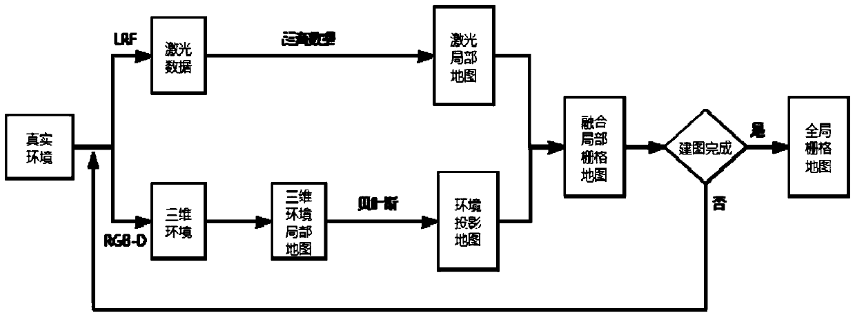
[0018] combine figure 1 , a method for constructing a map by a mobile robot of the present invention, comprising:

[0019] Step 1: When the robot uses Kinect and LiDAR to collect data, it selects feature points through image features to determine the data information needed to build a map. During the scanning process, it compares the matching degree of feature points between the current frame and the previous frame to further select Information more suitable for building maps. Then map the detected obstacle image coordinates to the actual working environment coordinates. According to the location information of the detected obstacles in the actual environment, it is determined that they belong to the discretized grid, and a local grid map is established.

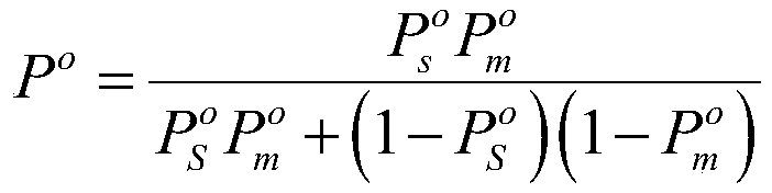
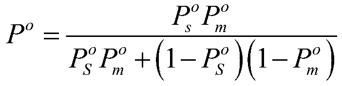
[0020] Step 2: Bayesian inference is a statistical data fusion algorithm based on t...


PUM


Abstract

The invention discloses a method for constructing a map by a mobile robot, and the method comprises the following steps: extracting a light beam through a probability heuristic model by utilizing a Bayesian method, projecting the light beam to a grid map unit, extracting consistency characteristic information by fully utilizing redundant information in laser and visual information, and carrying out characteristic-level information fusion; in a map updating stage, providing a Bayesian estimation method integrating a laser sensor and a visual sensor to update a raster map. According to the invention, through multi-sensor information fusion, the accuracy and robustness of SLAM can be effectively improved.

Description

technical field [0001] The invention relates to a method for building a map by a mobile robot, in particular to a method for building a map by a mobile robot based on information fusion. Background technique [0002] Considering the limited computing resources, there is a very strong demand for the miniaturization and light weight of SLAM. With the deepening of the research field of mobile robots, the tasks performed by mobile robots become more complex, and the external environment in which mobile robots work will become more complex. Only a single sensor cannot meet the demand for information data. The requirements for the accuracy of the mobile robot's own positioning and map construction are getting higher and higher, requiring multiple sensors to collect external environmental information. In the uncertain and complex environment of mobile robots in the prior art, a single sensor is generally used for simultaneous localization and map creation (SLAM), which has problem...

Claims


Application Information

Patent Timeline
Patent Type & Authority Applications(China)
IPC IPC(8): G06K9/62G06T7/50G06T17/05
CPCG06T17/05G06T7/50G06F18/22G06F18/29G06F18/25
Inventor 莫宏伟王泽华肖恭财许贵亮杨帆田朋姜来浩
Owner HARBIN ENG UNIV
Why Eureka
Try Eureka