Geospatial situation system for P2P network and construction method

A P2P network and geospatial technology, applied in the field of geospatial situation system and construction, can solve the problems of hard to repair data loss, unable to obtain on-site situation in time, achieve fast on-site situation, simple and fast data processing method, and avoid system paralysis Effect

Active Publication Date: 2020-08-14
中科全维科技(苏州)有限公司
View PDF7 Cites 3 Cited by
  • Summary
  • Abstract
  • Description
  • Claims
  • Application Information

AI Technical Summary

Problems solved by technology

[0004] In this solution, the situational data is mainly concentrated on the "cloud", and its visualization capability mainly serves the command personnel, while the front-line participants are limited by the network conditions at the incident site and the storage capacity of portable devices, so they cannot obtain the on-site situation in time ; and a large amount of situational data are all stored in a unified data center, if the data loss is caused by equipment failure or communication channel error, it will be difficult to repair

Method used


Image

  • Geospatial situation system for P2P network and construction method
  • Geospatial situation system for P2P network and construction method
  • Geospatial situation system for P2P network and construction method

Examples


Embodiment Construction

[0037] The following will clearly and completely describe the technical solutions in the embodiments of the present invention with reference to the drawings in the embodiments of the present invention. Obviously, the described embodiments are part of the embodiments of the present invention, not all of them. Based on the embodiments of the present invention, all other embodiments obtained by persons of ordinary skill in the art without making creative efforts shall fall within the protection scope of the present invention.

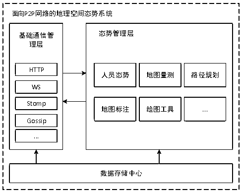
[0038] figure 1 It shows an architectural design diagram of a P2P network-oriented geospatial situation system according to an embodiment of the present invention, including:

[0039] The basic communication management layer integrates standard WEB communication protocols, establishes an information dissemination mechanism between nodes in the P2P network, integrates basic communication functions such as point-to-point communication, broadcast communicatio...


PUM


Abstract

The invention relates to a geospatial situation system for a P2P network and a construction method. The geospatial situation system for the P2P network comprises a basic communication management layerwhich integrates a standard WEB communication protocol and establishing an information propagation mechanism for nodes of the P2P network; a situation management layer which integrates various situation service functions for users, independently generates structured situation data or obtains the situation data from the P2P network for visualization, and stores the situation data to a data storagecenter; and the data storage center which constructs a distributed storage system by utilizing the network nodes and provides data support for the situation management layer. According to the invention, a lightweight geospatial situation system is established at the mobile terminal, functions of data sharing, situation distribution and the like are realized based on the P2P network, and actual use requirements of front-line participants in emergency events are met.

Description

technical field [0001] The invention relates to the field of mobile terminal information technology, in particular to a P2P network-oriented geospatial situation system and a construction method. Background technique [0002] The integrated geospatial situation includes satellite image data, equipment positioning data, and multimedia intelligence data obtained from on-site observation, collection, and investigation by participants. After data cleaning and screening, these comprehensive situational data are organized and managed through unified time and space, and finally form a visualized virtual situational scene, which is displayed in the situational application. [0003] In the current civilian field and emergency command field, the existing geospatial situational systems are mostly a combination of "cloud" and "end", and centered on the "cloud", a situational display platform is built based on big data. The data source It is mainly for the knowledge graph constructed on...

Claims


Application Information

Patent Timeline
Patent Type & Authority Applications(China)
IPC IPC(8): H04L29/08
CPCH04L67/02H04L67/104H04L67/1097
Inventor 黄廷磊马文宇夏威高建新翟文军唐小明
Owner 中科全维科技(苏州)有限公司
Why Eureka
Try Eureka