Vegetation classification method based on machine learning algorithm and multi-source remote sensing data fusion

A technology of machine learning and remote sensing data, applied in machine learning, neural learning methods, instruments, etc., can solve problems such as poor applicability and low accuracy, and achieve the effects of low equipment cost, complete parameter indicators, and strong operability

Pending Publication Date: 2020-08-18
CHINA HYDROELECTRIC ENGINEERING CONSULTING GROUP CHENGDU RESEARCH HYDROELECTRIC INVESTIGATION DESIGN AND INSTITUTE
View PDF3 Cites 24 Cited by
  • Summary
  • Abstract
  • Description
  • Claims
  • Application Information

AI Technical Summary

Problems solved by technology

[0002] Several monitoring methods such as satellite remote sensing single data source inversion (multispectral, hyperspectral, lidar and synthetic aperture radar) and field surveys used in the prior art have problems of poor applicability and low accuracy

Method used


Image

  • Vegetation classification method based on machine learning algorithm and multi-source remote sensing data fusion
  • Vegetation classification method based on machine learning algorithm and multi-source remote sensing data fusion
  • Vegetation classification method based on machine learning algorithm and multi-source remote sensing data fusion

Examples


Embodiment

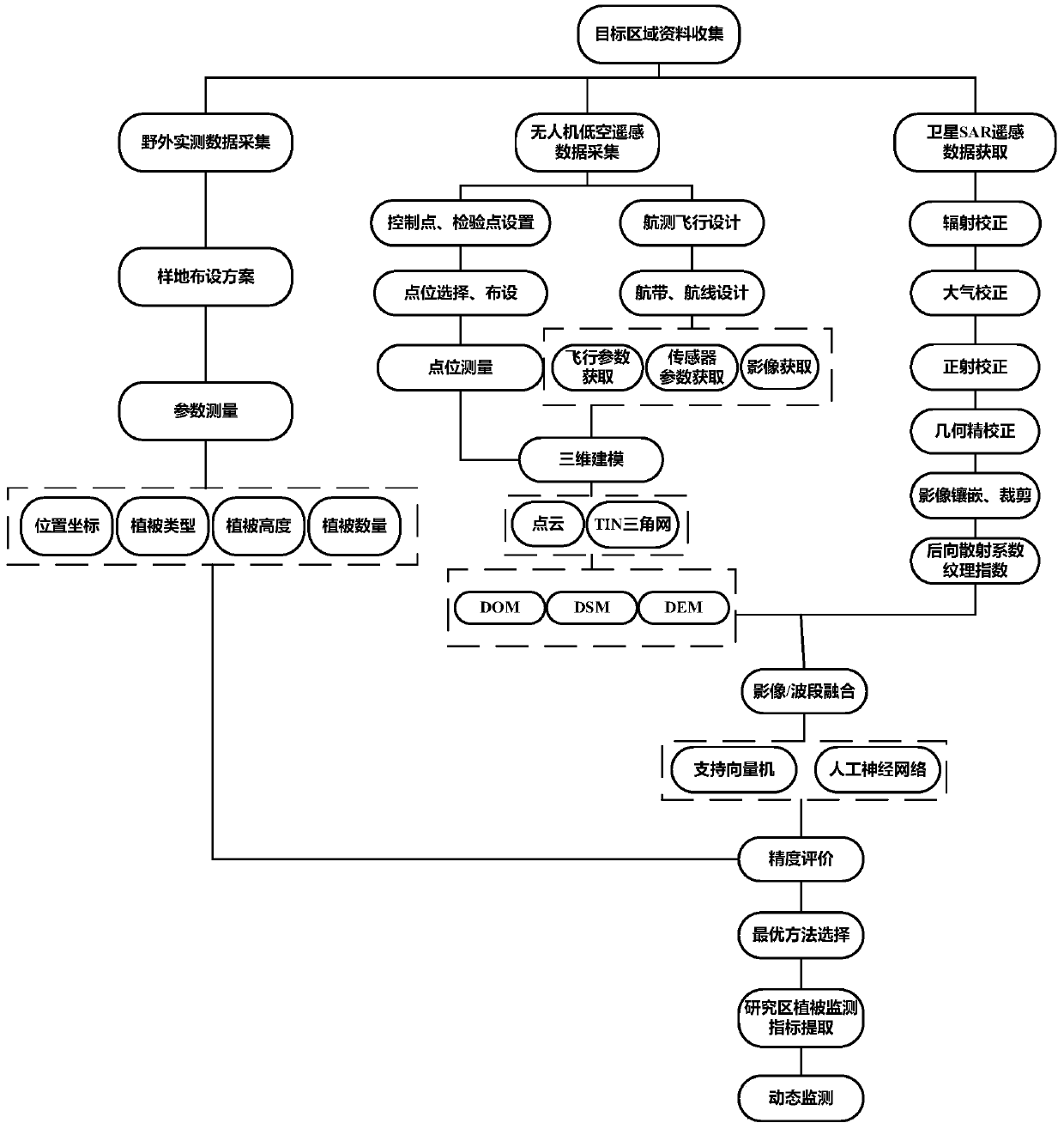
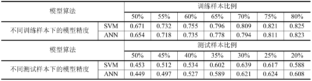
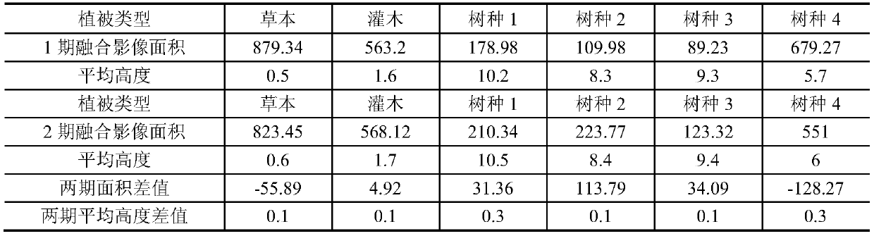
[0036] The method of the present invention will be further described below with reference to the accompanying drawings and embodiments. The embodiments are only to help readers better understand the method of the present invention, and are not intended to limit the protection scope of the claims of the present invention.

[0037] The methods provided by the embodiments based on multi-source remote sensing data fusion and object-oriented classification greatly improve the ability of accurate, efficient, quantitative acquisition, analysis, calculation and processing of different vegetation monitoring index data in the monitoring of terrestrial plant ecological environment. Revolutionary changes in the display effect and method of monitoring results. It fills in the technical gaps in the ecological environment monitoring work that there are no conventional monitoring methods and means for the quantitative monitoring of vegetation, and greatly improves the automation of field monitori...


PUM


Abstract

The invention relates to the field of ecological environment monitoring, and discloses a vegetation classification method based on a machine learning algorithm and multi-source remote sensing data fusion, which is used for efficiently realizing identification and classification of vegetation types in a target area. The method comprises the following steps: acquiring a low-altitude remote sensing image of terrestrial plants in a sample area by using an unmanned aerial vehicle, and acquiring a digital orthoimage and a digital surface model of the sample area based on the low-altitude remote sensing image; extracting elevation information of the digital surface model; acquiring an SAR image of a sample region corresponding to the aerial photography time of the unmanned aerial vehicle by utilizing satellite remote sensing; carrying out wave band and image fusion on the digital orthoimage, the elevation information and the SAR image; performing inversion model training and inversion model precision evaluation on the fused image through sample area actual measurement data and a machine learning algorithm to obtain an inversion model meeting requirements; and finally, classifying terrestrial plants in the target area based on the inversion model. The method is suitable for terrestrial plant ecological environment monitoring.

Description

Technical field [0001] The invention relates to the field of ecological environment monitoring, in particular to a vegetation classification method based on the fusion of machine learning algorithms and multi-source remote sensing data. Background technique [0002] Several monitoring methods such as satellite remote sensing single data source inversion (multispectral, hyperspectral, lidar and synthetic aperture radar) and field surveys used in the prior art have problems of poor applicability and low accuracy. Research on the fusion, classification and quantitative inversion of multi-source remote sensing data is the key to improving and enhancing the ecological environment monitoring technology. [0003] With the improvement of the types of satellites in my country, including high-resolution, hyper-spectral, synthetic aperture radar (SAR) and other sensors, as well as the supplement and enhancement of low-altitude remote sensing for UAVs, an all-weather, all-round combination of ...

Claims


Application Information

Patent Timeline
Patent Type & Authority Applications(China)
IPC IPC(8): G06K9/00G06K9/62G06N3/04G06N3/08G06N20/00
CPCG06N3/08G06N20/00G06V20/188G06N3/045G06F18/2411
Inventor 周湘山秦甦戴松晨张磊冯博李秋水詹晓敏周杰
Owner CHINA HYDROELECTRIC ENGINEERING CONSULTING GROUP CHENGDU RESEARCH HYDROELECTRIC INVESTIGATION DESIGN AND INSTITUTE
Why Eureka
Try Eureka