High-resolution image landslide automatic detection method based on multi-level perception feature progressive self-learning

A high-resolution, multi-level technology, applied in neural learning methods, instruments, biological neural network models, etc., can solve problems such as irregular features, stagnant learning, and inability of machines to accurately learn image features. The effect of enhancing the ability to connect

Active Publication Date: 2020-08-21
浙江中海达空间信息技术有限公司
View PDF2 Cites 4 Cited by
  • Summary
  • Abstract
  • Description
  • Claims
  • Application Information

AI Technical Summary

Problems solved by technology

[0007] While analyzing and mining remote sensing data, we are faced with the problem that a large number of non-standard features cannot be effectively used, so that the machine cannot accurately l

Method used


Image

  • High-resolution image landslide automatic detection method based on multi-level perception feature progressive self-learning
  • High-resolution image landslide automatic detection method based on multi-level perception feature progressive self-learning
  • High-resolution image landslide automatic detection method based on multi-level perception feature progressive self-learning

Examples


Embodiment Construction

[0034] Below in conjunction with accompanying drawing, technical scheme of the present invention is described in further detail:

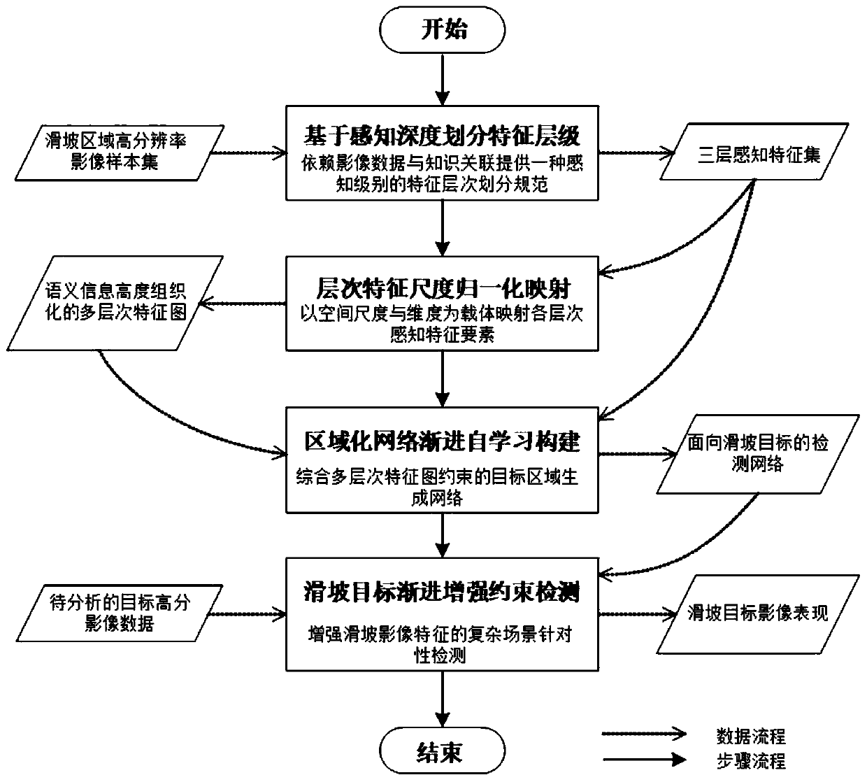
[0035] Such as figure 1 As described above, the multi-level perceptual feature progressive self-learning method for landslide hazards based on high-resolution remote sensing images of the present invention includes the following steps 1-4.

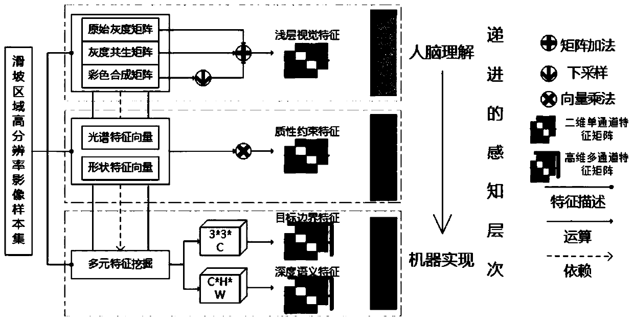
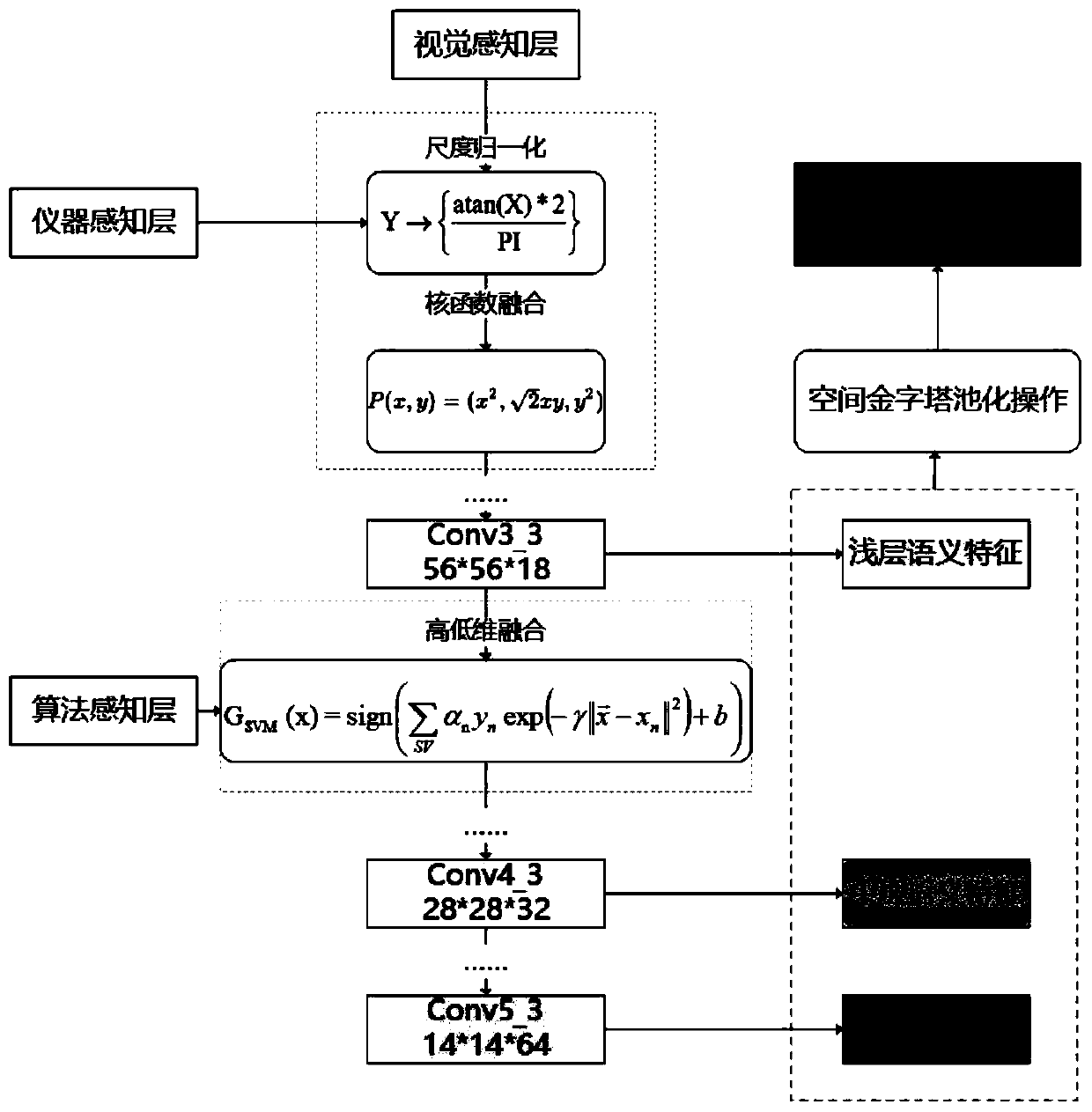
[0036] Step 1. Divide feature levels based on perceptual depth. Using high-resolution images of the landslide area, based on perception depth-dependent image data and knowledge association, three feature levels are divided: visual perception layer, instrument perception layer and algorithm perception layer, and a three-layer perception feature set is obtained to support the progressive perception level. Feature normalization mapping; where the human eye's color perception of the image is the layered representation of the visual perception layer, the data characteristic perception recorded by the remote sensing...


PUM


Abstract

The invention relates to a high-resolution image landslide automatic detection method based on multi-level perception feature progressive self-learning, and the method comprises the steps: 1, dividingfeature levels based on perception depth through employing a high-resolution image of a landslide region in order to support the feature normalization mapping of perception level progressive; 2, establishing a scale normalization model with progressively enhanced features, mapping perception feature elements of each level by taking spatial scales and dimensions as carriers, and generating a multi-level feature map with highly organized semantic information; 3, constructing a progressive self-learning regionalized network integrated with multi-level feature map constraints, and generating a landslide target-oriented detection network through end-to-end training; and d) inputting to-be-analyzed target high-resolution image data to the detection network, performing targeted detection of thelandslide target from the perspective of gradually enhancing image features, and finally outputting landslide target image representation. The method overcomes the defect of single understanding of complex scene images in the prior art, enhances the association ability between the features, and enables the detection result to be more accurate.

Description

technical field [0001] The invention belongs to the technical field of geospatial data processing, and in particular relates to a high-resolution image landslide automatic detection method for progressive self-learning of multi-level perceptual features. Background technique [0002] Due to the widespread, lossy, and threatening effects of landslide hazards, effective and rapid identification of them has become an urgent problem to be solved today. Field surveys can no longer meet the needs of landslide disaster identification, and identification using optical satellite remote sensing technology has become the mainstream. Among them, target recognition based on object-oriented classification method can extract key information and target area, combined with visual interpretation, can obtain detailed information of landslides, and improve the success rate of remote sensing image landslide interpretation. [0003] The research results show that using the traditional object-ori...

Claims


Application Information

Patent Timeline
IPC IPC(8): G06K9/00G06K9/62G06N3/04G06N3/08
CPCG06N3/08G06V20/13G06V2201/07G06N3/045G06F18/214G06F18/253
Inventor 谢潇伍庭晨张叶廷刘铭崴许飞
Owner 浙江中海达空间信息技术有限公司
Why Eureka
Try Eureka