
Unmanned aerial vehicle and ground cooperative processing system for vehicle detection

A vehicle detection and unmanned aerial vehicle technology, applied in radio transmission systems, transmission systems, traffic flow detection and other directions, can solve the problems of large system delay, low precision, data loss, etc., and achieve good real-time results

Active Publication Date: 2020-09-04
AEROSPACE INFORMATION RES INST CAS
View PDF8 Cites 2 Cited by
  • Summary
  • Abstract
  • Description
  • Claims
  • Application Information

AI Technical Summary

Problems solved by technology

The traditional working mode is to transmit data back to the ground station and calculate it, which has a large system delay
In addition, when multiple drones work at the same time, all the image data generated will be sent back to the ground station, which will also put great pressure on the network bandwidth.
[0003] At present, most scientific research institutions only send the images acquired by drones to the ground processing station, and the ground processing station performs intelligent target detection, but there will be problems such as delay, low precision and data loss.

Method used


Image

  • Unmanned aerial vehicle and ground cooperative processing system for vehicle detection
  • Unmanned aerial vehicle and ground cooperative processing system for vehicle detection
  • Unmanned aerial vehicle and ground cooperative processing system for vehicle detection

Examples


Embodiment 1

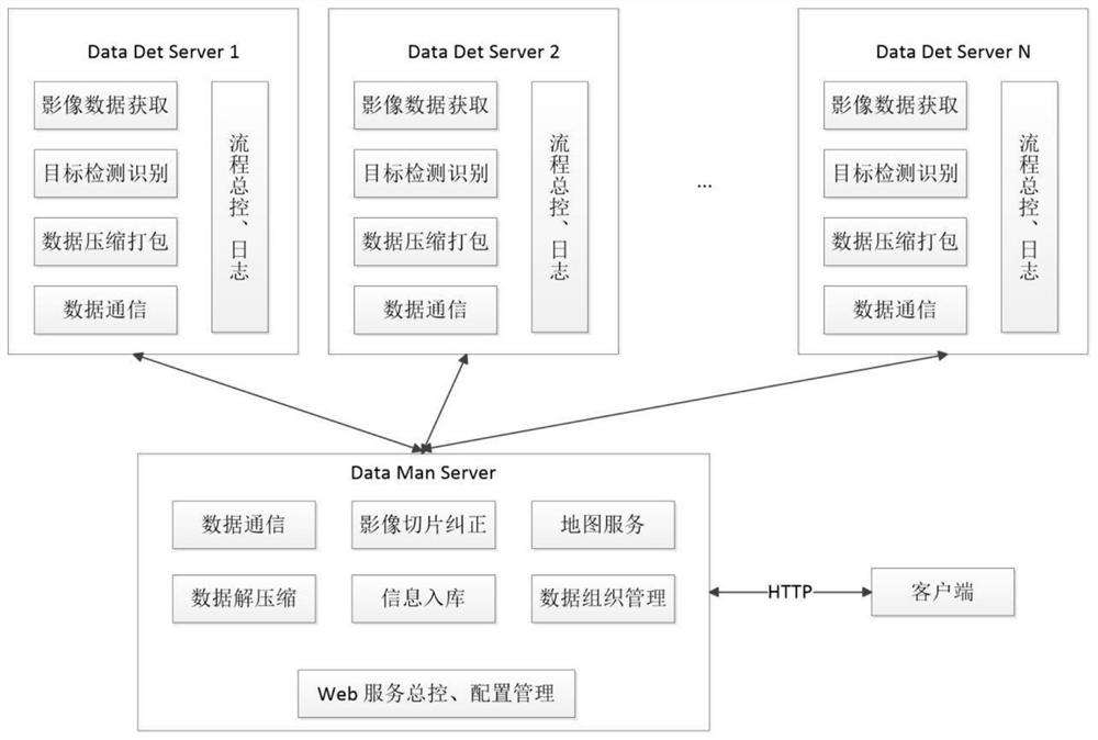
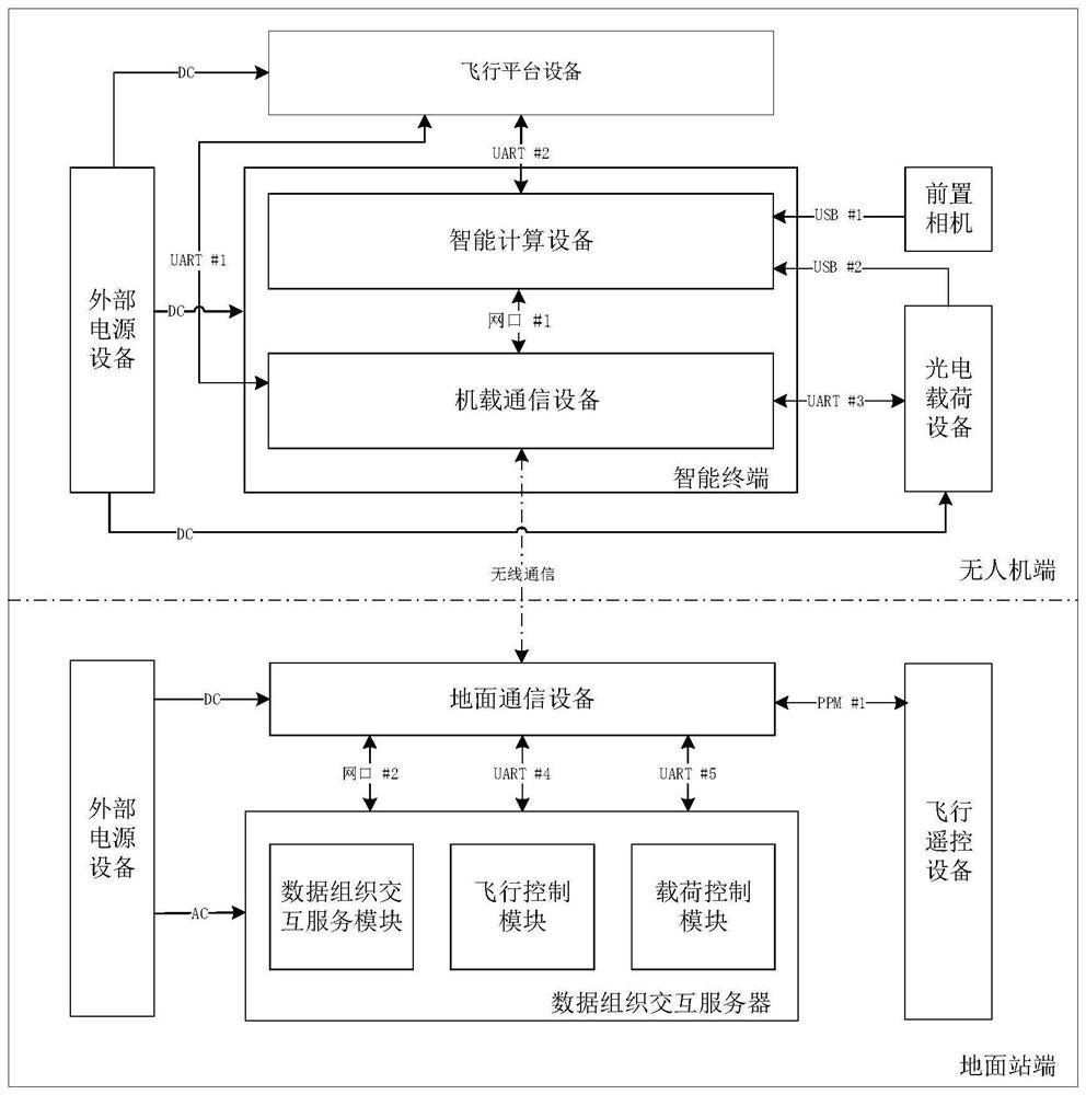
[0041] A UAV and ground collaborative processing system for vehicle detection provided by the present invention such as figure 1 As shown, including: an unmanned aerial vehicle and a ground control station connected by wireless communication with the unmanned aerial vehicle;

[0042] The unmanned aerial vehicle is used to obtain ground image data in real time, and perform convolution calculation on the ground image data to determine target vehicle information and image slices of the target vehicle, and transmit them to the ground control station. The target vehicle information includes: The category of the target vehicle, the image pixel coordinates and latitude and longitude coordinates in the ground image data;

[0043] The ground control station is used for analyzing and storing target vehicle information and image slices of the target vehicle.

[0044] Specifically, in order to solve the problems of high delay and large bandwidth consumption in the prior art, the present ...


PUM


Abstract

The invention provides an unmanned aerial vehicle and ground cooperative processing system for vehicle detection. The system is characterized by comprising an unmanned aerial vehicle and a ground control station in wireless communication connection with the unmanned aerial vehicle; the unmanned aerial vehicle is used for acquiring ground image data in real time, performing convolution calculationon the ground image data to determine target vehicle information and an image slice of a target vehicle, and transmitting the target vehicle information and the image slice to the ground control station, and the target vehicle information comprises the category of the target vehicle, and image pixel coordinates and latitude and longitude coordinates in the ground image data; and the ground controlstation is used for analyzing and storing the target vehicle information and the image slice of the target vehicle. The adopted unmanned aerial vehicle only sends the target detection result and thetarget image slice to the ground control station, so that the sending data amount is reduced; due to onboard processing of the unmanned aerial vehicle, a large amount of data does not need to be transmitted back to the ground end, and the real-time performance becomes better.

Description

technical field [0001] The invention belongs to the technical field of unmanned aerial vehicle system target detection, and in particular relates to an unmanned aerial vehicle and ground cooperative processing system for vehicle detection. Background technique [0002] With the rapid development of aerial remote sensing technology, UAV-based remote sensing application technology has gradually matured, providing a technical application basis for the development of more flexible and autonomous remote sensing image intelligent information processing systems. The traditional working mode is to transmit data back to the ground station and calculate it, which has a large system delay. In addition, when multiple drones work at the same time, all the image data generated will be sent back to the ground station, which will also put great pressure on the network bandwidth. [0003] At present, most scientific research institutions only send the images acquired by drones to the ground...

Claims


Application Information

Patent Timeline
Patent Type & Authority Applications(China)
IPC IPC(8): G08G1/04H04B7/185H04L29/06H04L29/08
CPCG08G1/04H04B7/18506H04L67/02H04L67/06H04L69/162H04L67/55
Inventor 孙显付琨赵良瑾闫梦龙刁文辉柴亚捷耿凯闫志远张义李浩
Owner AEROSPACE INFORMATION RES INST CAS
Learn More